Some thoughts on this cold Wednesday in February.
- Greg officially hates Differential Equations. This is going to be a long semester that requires lots of hard work and patience, two things I generally lack.
- Man it got cold last night! Most of Eastern MA started the day in the mid 30's. By 4pm, we were in the upper teens! Arctic cold fronts get you every time. The wind was quite strong too. Think of it like this, if you have ever opened a sealed container and felt and heard air rush into it, that is what we experienced last night. Cold air literally rushing into our region.
- Potholes suck. Big time. And you all know that there are TONS of them out there right now. I hit one yesterday and it took me out. Some of them are ridiculously big. But honestly there is nothing you can do about them. You really can't fix them until we start getting consistently warmer weather , which is late March early April. Fix them now and they will likely open up again in a few days. Yuck!!!
- Feel free to wave goodbye to our near miss of a storm tomorrow. Currently it is wreaking havoc in the south. Areas like Arkansas, Alabama and Tennessee are getting a pretty substantial snow storm. Oklahoma City and Dallas saw significant snowfall for the second time in 1 week. Unusual for them and believe me when I say that these people have no idea how to handle snow. My friend Sarah Brown reports that Memphis has 5 inches of snow and there are accidents everywhere. Don't feel too bad for them though. These same areas will be close to 70 degrees next week.
- While we are on the topic of other places getting snow, Japan is getting a pretty good snowstorm as we speak. Something tells me that they are more efficient at cleaning it up though.
- I was not alive in 1969(in case you were wondering) but on Feb 8-9th, our region was currently getting leveled with what is famously known in New York as Mayor Lindsay's Snowstorm in. Although only 15 inches fell in the city, amazingly 14 people died! I know that forecasting has gotten better since then but judging by Bloomberg's reaction to this past December's snowstorm, New York still hasn't figured out how to deal with snow.
- My cousins better be reading this because I am using this space to talk about San Fransisco weather. And you know what the weather is? Boring. You guys are protected out there right now by strong high pressure. No rain in sight. In fact, that dryness might become a problem down the road. But for now, you will see sun and fun. Maybe not so much fun for the cousin who is pregnant with twins though.
- I intended to work on homework all night. Time spent on homework, 90 min. Time spent blogging and jerking around on the internet, well over 2 hours.
I think I will finish on that note. Stay warm!
Wednesday, February 9, 2011

Monday, February 7, 2011
Tomorrow? No Sweat
So for the first time in a long time this winter, two storms will be forming along the east coast and neither one is going to hit us.
Tonight, a storm will hit the water off the coast of North Carolina and slide harmlessly out to sea, several hundred miles south of Nantucket. At the same time, a weak storm will be moving towards us from the Great Lakes. This storm will be little more than a nuisance though but because that big storm will be providing some strong winds from the south to help enhance the little storm. Probably about 2-3 inches over interior MA and maybe 1 inch inside of I95 since surface temps will be close to if not above 32. This will all be over by mid afternoon tomorrow.
Many of you have asked about our MEGA storm on Thursday. Well its off, for us at least. A major pattern change is going to happen (although we might not see much of a difference in New England) and there is going to be some very cold air settling across much of the country, followed by a HUGE warm up. Remember how Dallas had snow and 20 degree temps this week? How about 80 degrees for them next week. Chicago might make it to the mid 50's. DC and Baltimore will get close to 60. This is all next week of course and before that, many of these areas will see a very large storm. Such temperature extremes always create big storms. This will be a big one for the deep south with snow/freezing rain and and ice. A big mess for them coming Thursday.
For us, we are now under the protection of a big High Pressure block. Its a good news/bad news situation. The good news is that this blocking high will push all storms out to sea and away from us. The bad news is that it will also keep us in a "cold bubble" that prevents us from seeing the big warm up that the rest of country sees.
Oh well.
Tonight, a storm will hit the water off the coast of North Carolina and slide harmlessly out to sea, several hundred miles south of Nantucket. At the same time, a weak storm will be moving towards us from the Great Lakes. This storm will be little more than a nuisance though but because that big storm will be providing some strong winds from the south to help enhance the little storm. Probably about 2-3 inches over interior MA and maybe 1 inch inside of I95 since surface temps will be close to if not above 32. This will all be over by mid afternoon tomorrow.
Many of you have asked about our MEGA storm on Thursday. Well its off, for us at least. A major pattern change is going to happen (although we might not see much of a difference in New England) and there is going to be some very cold air settling across much of the country, followed by a HUGE warm up. Remember how Dallas had snow and 20 degree temps this week? How about 80 degrees for them next week. Chicago might make it to the mid 50's. DC and Baltimore will get close to 60. This is all next week of course and before that, many of these areas will see a very large storm. Such temperature extremes always create big storms. This will be a big one for the deep south with snow/freezing rain and and ice. A big mess for them coming Thursday.
For us, we are now under the protection of a big High Pressure block. Its a good news/bad news situation. The good news is that this blocking high will push all storms out to sea and away from us. The bad news is that it will also keep us in a "cold bubble" that prevents us from seeing the big warm up that the rest of country sees.
Oh well.
Sunday, February 6, 2011
Ladies and Gentlemen, The End is Near
So I apologize for my absence over the last few days. A combination of work, drinking and laziness generally are the reasons behind my lack of blogging. I have been getting some great feedback from people though and I love it so keep it up!
Some of that feedback centered around my post about a monster storm that was going to occur next Thursday. I have to admit that I was fueling the flames a bit on that one. Anything that is predicted 7 days out has a minimal chance of playing out the way it is predicted, however, I did have some basis for thinking this storm was and quite possibly still could happen.
Lets start with a quick explanation as to what has been going on this year. As most of you know, this year is classified as a La Nina winter. Simply put, La Nina is defined as cooler than normal sea-surface temperatures in the central and eastern tropical Pacific ocean that impact global weather patterns.Below is an image of what a typical La Nina winter pattern looks like in the US.
 A few things to note. Notice that the northern portion of the jet stream typically stays to our north and keeps the real arctic air away from our region and also keeping us in a milder and wetter pattern. Also notice the strong moisture flow from the pacific into the pacific northwest, a pattern that was verifying early in December if you can remember how much rain and snow Washington and Oregon were getting.
Now lets take a look at what has happened since around Christmas time.
 See the difference? The northern branch of the jet stream has shifted further south and at times has "phased" with the southern jet stream to tap into warm gulf moisture and create large winter storms that have continued to hit us over and over again. Another big difference is the cold air. Cold air has essentially been locked in over our heads for the last 40 days. This is one of the big reasons as to why we have had no melting and have large snow piles all over the place.
Obviously, this is a very quick rundown of our winter pattern this year and there are much more integrate things going on here that are playing into our very snowy 2011. However, I bring this point up to illustrate a bigger point. The end is near.
All signs point to a very large pattern change beginning next week and lasting quite possibly for the remainder of the winter. No image to show this right now but here are the 3 major points.
1. Storms will come from the West now instead of the south.
2. The south storms will move west of the coast providing bigger snows for inland areas.
3. The cold air is losing the battle with the warm air.
But of course, before this happens, we need a large storm to signal the shift in patterns. That storm still looks to happen on Thursday. Now, just because the storm will exist does not mean that it will hit us or even if it hits us, it does not mean that it will be all snow.
One thing is certain though. Expect warmer temperatures for the rest of the month starting next weekend. Let the melting and the march towards spring commence!
Some of that feedback centered around my post about a monster storm that was going to occur next Thursday. I have to admit that I was fueling the flames a bit on that one. Anything that is predicted 7 days out has a minimal chance of playing out the way it is predicted, however, I did have some basis for thinking this storm was and quite possibly still could happen.
Lets start with a quick explanation as to what has been going on this year. As most of you know, this year is classified as a La Nina winter. Simply put, La Nina is defined as cooler than normal sea-surface temperatures in the central and eastern tropical Pacific ocean that impact global weather patterns.Below is an image of what a typical La Nina winter pattern looks like in the US.
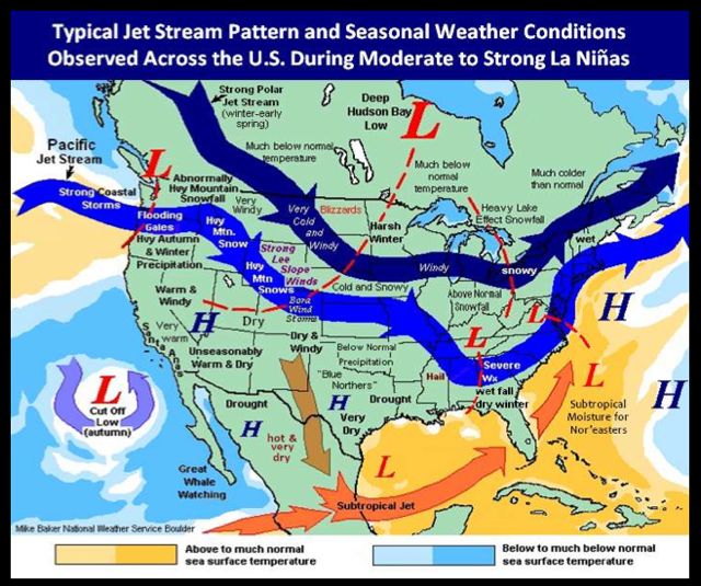 A few things to note. Notice that the northern portion of the jet stream typically stays to our north and keeps the real arctic air away from our region and also keeping us in a milder and wetter pattern. Also notice the strong moisture flow from the pacific into the pacific northwest, a pattern that was verifying early in December if you can remember how much rain and snow Washington and Oregon were getting.
Now lets take a look at what has happened since around Christmas time.
 See the difference? The northern branch of the jet stream has shifted further south and at times has "phased" with the southern jet stream to tap into warm gulf moisture and create large winter storms that have continued to hit us over and over again. Another big difference is the cold air. Cold air has essentially been locked in over our heads for the last 40 days. This is one of the big reasons as to why we have had no melting and have large snow piles all over the place.
Obviously, this is a very quick rundown of our winter pattern this year and there are much more integrate things going on here that are playing into our very snowy 2011. However, I bring this point up to illustrate a bigger point. The end is near.
All signs point to a very large pattern change beginning next week and lasting quite possibly for the remainder of the winter. No image to show this right now but here are the 3 major points.
1. Storms will come from the West now instead of the south.
2. The south storms will move west of the coast providing bigger snows for inland areas.
3. The cold air is losing the battle with the warm air.
But of course, before this happens, we need a large storm to signal the shift in patterns. That storm still looks to happen on Thursday. Now, just because the storm will exist does not mean that it will hit us or even if it hits us, it does not mean that it will be all snow.
One thing is certain though. Expect warmer temperatures for the rest of the month starting next weekend. Let the melting and the march towards spring commence!
Thursday, February 3, 2011
Want To See Something Scary?

Possible storm of the decade next Thursday?? Haha, I couldn't resist. But it looks big now, causing some buzz...
Wednesday, February 2, 2011
Impressive Storm Totals Nationwide
Here is the official NWS summary of our now departed storm.
Storm Totals
The Mid West got slammed with this one more than we did.
-Chicago had 19.5 inches of snow, 3rd biggest single storm total all time.
-Area in Wisconsin, Illinois, Missouri, Oklahoma and Vermont got over 20 inches of snow.
-Top wind gusts reached 78 mph in Tennessee! A sure sign that the storm was getting very intense
Storm Totals
The Mid West got slammed with this one more than we did.
-Chicago had 19.5 inches of snow, 3rd biggest single storm total all time.
-Area in Wisconsin, Illinois, Missouri, Oklahoma and Vermont got over 20 inches of snow.
-Top wind gusts reached 78 mph in Tennessee! A sure sign that the storm was getting very intense
Why We Mix
So it should seem surprising to most people that in Boston last night around midnight, the temperature was 22 degrees. Even as I write this at 8:30 AM, my outside temperature in West Roxbury is 30 degrees, but I am getting all sleet right now. So how and why does this happen?
This reminds me of an argument I once had with my good friend Ryan Hansen. Hansen claimed that it HAD to be 32 degrees to snow no matter what. If it was any warmer, snow just couldn't exist. I, of course, disagreed and tried to explain to Hansen that it in fact can snow if the ground temperature is above 32. This is usually when you see those big almost fake looking snowflakes with very high water content. It is the result of cold air sitting right over our heads and precipitation falling very fast, so fast that it doesn't have time to melt before it reaches ground level. Of course, this snow doesn't stick to much of anything except grass and cars BUT it does prove that it can snow when it is above 32 degrees.
I bring up this story because sleet/ice and that magenta coloring that you see on your radars today works in a very similar way, just backwards. (On a side note, I love how mixing is depicted on the radar! Its like a ball of uncertainty coming towards you!!) Anyways, despite us having very cold air in place at the surface, you need to remember that our atmosphere is quite complex and more importantly, it continues up in the air for many miles! As I explained to Hansen, just because our surface temperature is cold enough for snow does not mean that we will get snow. The reason is somewhat complex, but in layman's terms, its because the air about 2000ft above us is too warm and is in fact above freezing.
This particular storm affecting us today is VERY large. Many people saw the satellite images of it yesterday and heard horror stories from the midwest of epic snowfall totals. This storm is so large that it began to suck up some very warm air from the Gulf of Mexico. That warm air ran into our firmly entrenched cold air (cold air that has been pretty much the result of a stationary high pressure system over Iceland all winter!). Our cold air actually won the battle, but as we all know, warm air rises and despite losing the battle at ground level, the warm air has risen above the cold air and now has the "high ground" which any battlefield nerd will tell you is the most important thing in a fight!
The result of this process is what you see today, sleet and ice. The air above us warms falling precipitation so much that by the time it hits the cold air at the surface, it doesn't have time to freeze back up. The result is sleet, which is basically just a half assed snow flake. Ice is much more dangerous. Ice happens when the falling precipitation makes it all the way down to the surface as just a cold rain drop but then freezes immediately on impact. This usually happens when there is a bigger difference in surface temp and low level atmosphere temp. I don't think Boston will have a problem with ice today because our surface temp will continue to warm up but other areas away from the influence of the water might have an icing issue.
Ok, so now you know why it sleets and ices. By the way, despite my logical explanation to Hansen, he still didn't believe me. Anyone who has ever had an argument with Hansen knows that he doesn't give up easily.
This reminds me of an argument I once had with my good friend Ryan Hansen. Hansen claimed that it HAD to be 32 degrees to snow no matter what. If it was any warmer, snow just couldn't exist. I, of course, disagreed and tried to explain to Hansen that it in fact can snow if the ground temperature is above 32. This is usually when you see those big almost fake looking snowflakes with very high water content. It is the result of cold air sitting right over our heads and precipitation falling very fast, so fast that it doesn't have time to melt before it reaches ground level. Of course, this snow doesn't stick to much of anything except grass and cars BUT it does prove that it can snow when it is above 32 degrees.
I bring up this story because sleet/ice and that magenta coloring that you see on your radars today works in a very similar way, just backwards. (On a side note, I love how mixing is depicted on the radar! Its like a ball of uncertainty coming towards you!!) Anyways, despite us having very cold air in place at the surface, you need to remember that our atmosphere is quite complex and more importantly, it continues up in the air for many miles! As I explained to Hansen, just because our surface temperature is cold enough for snow does not mean that we will get snow. The reason is somewhat complex, but in layman's terms, its because the air about 2000ft above us is too warm and is in fact above freezing.
This particular storm affecting us today is VERY large. Many people saw the satellite images of it yesterday and heard horror stories from the midwest of epic snowfall totals. This storm is so large that it began to suck up some very warm air from the Gulf of Mexico. That warm air ran into our firmly entrenched cold air (cold air that has been pretty much the result of a stationary high pressure system over Iceland all winter!). Our cold air actually won the battle, but as we all know, warm air rises and despite losing the battle at ground level, the warm air has risen above the cold air and now has the "high ground" which any battlefield nerd will tell you is the most important thing in a fight!
The result of this process is what you see today, sleet and ice. The air above us warms falling precipitation so much that by the time it hits the cold air at the surface, it doesn't have time to freeze back up. The result is sleet, which is basically just a half assed snow flake. Ice is much more dangerous. Ice happens when the falling precipitation makes it all the way down to the surface as just a cold rain drop but then freezes immediately on impact. This usually happens when there is a bigger difference in surface temp and low level atmosphere temp. I don't think Boston will have a problem with ice today because our surface temp will continue to warm up but other areas away from the influence of the water might have an icing issue.
Ok, so now you know why it sleets and ices. By the way, despite my logical explanation to Hansen, he still didn't believe me. Anyone who has ever had an argument with Hansen knows that he doesn't give up easily.
Tuesday, February 1, 2011
First Storm is Winding Down
Well, that was round 1. Rough timing with this one. I was witness to numerous spinouts and even minor car accidents. Not much you can do when you get heavy snowfall in the middle of the day. Generally 5-9 inches fell, which is what was forecasted.


Take a look at this. It gives you a very good image of our 1, 2 punch. That big guy in the middle is round 2.
She is a big storm, with lots of moisture to drop. She is also going to take a very strange path,which is the reason we have a lot of precipitation type questions.
Anyways, enjoy the break for now!
Subscribe to:
Posts (Atom)