Tuesday, June 28, 2011

July 4th Weekend

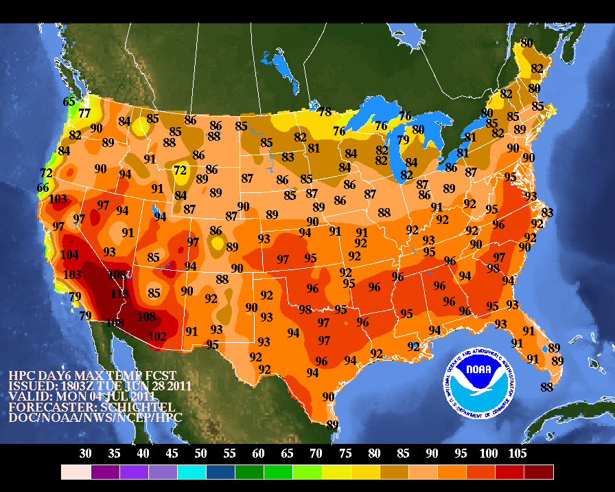
Well, the rest of the east coast will be experiencing a nice 2 day heat wave starting on Saturday. What about us? Right now, it looks like we get a nice warm weekend with mixed clouds and sun but dry at the very least. Check out the 3 day temperature forecasts countrywide for the holiday weekend.

Saturday


Sunday


Independence Day

Sunday, June 26, 2011

July 4th Weekend Heat Wave

Not too early to look to next holiday weekend! Early indications show some 90 degree + heat for July 2nd and 3rd for pretty much the whole east coast.

New England is included in that heat burst right now but another pesky cut off low might hover near Nova Scotia and give us a cool and cloudy wind off the water. Sound familiar? Seems like we have had a lot of that lately. Keep your fingers crossed for the heat!

July 2nd


July 3rd

Monday, May 23, 2011

Hello Spring, Its Me. Are You Out There?

So my breaking point was at the red sox game this past Saturday night. I knew it was going to be a tough week. Lots of clouds, intermittent rain and a pesky on shore flow that kept our temperatures well below where they should be. But I have a personal rule, I will not attend a red sox game before the 2nd week of May as I do not care to be sitting in an old wooden chair all bundled up drinking my overpriced and under served beer.

So with two games last week, I assumed all off season that I would be in the clear. Not so my friends. Wednesday? I felt like I was watching a haunted baseball game with the consistent cloud of mist that hovered over Fenway all night. It was so shitty out that I wasn't even able to find a last minute person to accompany me to the game. First time that has ever happened. By the time the downpour came in the 7th inning, I was way too drunk and way to close to the field to give up on the game. I stuck it out till the end and saw a great game. Got soaked and felt like a loser going alone but it all worked out in the end.

Saturday, things could not have looked better. It began on Friday afternoon when we finally saw the sun sneak through after 5+ days of cloud cover. Saturday morning started out foggy as hell but once it burned off, the whole region (except for Cape Cod) jumped up t0 70 degrees. Beautiful! But a classic New Enlgand spring time curve ball was coming.

Those few of you that follow my twitter feeds might have seen the tweet i put up on Saturday morning about how everyone should enjoy the warmth but to be careful to not get caught in shorts later on because a cold front was moving through and a big change was in store. I had no idea how right I would be.

We left for the game on Saturday afternoon at 4:45 with the temperature hovering just above 70 degrees, ample sunshine and no wind at all. By the time we got to our seats at 6:50, the temperature had dropped to 52 degrees, the winds had picked up dramatically out of the north east and my good friend the spooky mist cloud had settled over Fenway again. What a joke.

My breaking point came in the top of the 7th. Even my partially obstructed view could not obstruct the bitter cold wind that kept cutting through my thin and probably too tight clothing. Judging by the outcome of the game, that decision may have been the best one of the night.

So I have joined you all. I am not talking anyone off the ledge anymore. I am fed up with this pattern and I crave the springtime weather that we all love before it gets too damn hot and humid.

I wish I could say that I had good news for you all. But after a nice warm up tomorrow (albeit with little to no sunshine) we fall back to our on shore and cloudy flow for the remainder of the week. It will be warmer at least. No more 50 degree days. Unless the rapture actually did happen and our hell suddenly becomes and endless stretch of cloudy 50 degree days. I think that would be called purgatory though.

Sunday, May 15, 2011

This Weeks Weather Will Suck

It happens every spring. While most of us are thinking about longer days, warmer temperatures and trips to the beach, your atmosphere is going to give you a blunt reminder that we aren't into summer just yet.

The problem really is that our jet stream has moved wayyyyy to the north of us, keeping us and really most of the country stuck. This Accuweather graphic gives a good visual on the situation.


That upper level low will just sit and spin to our south west, giving us a wind off the 40 degree water all week. Translation, lots of clouds, lots of instability and the sudden urge to wear flannel and drink lattes because it will feel like we are in Seattle. For the record, I drink lattes on a regular basis.

So, no need for the sunglasses this week. We might break out of the pattern come next weekend but that is anyone's guess at this point.

I am glad that I will have a lovely 50 degree gray and wet night for my first red sox game of the season on Wednesday. Speaking of which, I have no one to go with to the game. Any takers? You would have to buy me at least one drink.

Good news ahead though. Look below.

Long range ECMWF model shows a nice warm week and memorial day weekend for us. That's great news for those of you planning bbq's, bachelor parties or cape cod events. Me? I have to work so screw you all. I don't mean it though. Memorial Day weekend is the unofficial start of summer so I like the warm forecast.

Just get through this week and I promise you good things soon!

Saturday, May 7, 2011

Mississippi Flooding is Getting Serious

By now, I am sure most of you have heard about the dangerous outbreak of tornadoes that happened about two weeks ago in the Alabama/Mississippi/Tennessee area. In actuality, it has been a very active year for tornadoes throughout the middle part of the country.

But an additional and potentially much more devastating consequence of an active storm pattern this spring is the tremendous amount of rainfall that has fallen in the lower Mississippi Valley. All of that rain finds its way to the Mississippi River and that river is ready to burst!


Things are getting serious in a hurry. From the image above, you can see that the likely cresting point for the river is sometime next week. But look at those water levels! They are right at record values.

Flooding certainly isn't as "sexy" as tornadoes, but there is no doubt that this type of flooding will be much more devastating than any tornado outbreak can ever be.

Friday, April 1, 2011

A Look Into the Future

That wasn't too bad today, right? Just a little coating of some heavy wet snow. No biggie. Overall the day was pretty damp. Lots of moisture in the air taking many forms. Rain, sleet, snow, all 3 at once. Not a nice day but its done now.

Naturally, people are itching for some actual spring weather. And they aren't wrong for feeling that we are overdue for some 70 degree warmth. In fact, over the last 5 years, Boston's average first 70 degree day of the season has been in the last week of March. he earliest date over that period was March 10th (in 2006) and the latest was April 17th (2009). So if we get to April 17th and still no 70, then we have a problem.

Taking a very broad, and i do mean broad, look at the next few weeks, the cold air will ease but it doesn't look especially warm either. The recently released NWS temperature outlook for April confirms.


I am sure we will get a warm day at some point in the next few weeks but there doesn't look like an extended period of warmth.

Wednesday, March 30, 2011

Seperating Truth from Fiction

So I admit it. The thought of a late season snowstorm on the first day of April got me very excited. Thoughts of 1997 were dancing in my head. I was imagining heavy snowfall rates, isolated 2 foot totals and a perfect wrap to a very disjointed winter. I may have gotten a little ahead of myself.

For those dedicated dozen regular readers (yes i counted mom twice) you know that I try to stay away from the heavy scientific explanations but sometimes this means I ignore the science side of forecasting a little too much.

Snow on April 1st? Sure its been done but it is no easy feat for mother nature to accomplish. And in rare situations like this, it is best to deal with two categories: what we know and what we don't know.

What we know
- A recent pattern change has allowed for several coastal low pressures to develop and take a run up the east coast.

-Storm 1 is in the gulf of mexico as we speak, bringing severe weather and drenching rains to the southeast. This storm will redevelop (as per usual) off the south carolina coast but will move much too far south to affect us. We are being protected by a blocking high pressure system to our east.

- A second storm will develop in nearly the exact same spot as storm 1 but this time will be allowed to ride up the coast as our high pressure moves further off shore. As it redevelops over water, it will pick up strength and moisture and intensify ever more as it collides with a pretty cold late March air mass that has been stubbornly sitting over us for a week. This battle ground of cold and warm air is very key.

- Our second storm will be strong with high winds and plenty of moisture. These early spring storms always have a lot of moisture. Remember our 14 inch rainfall in the last two weeks of March last year? Thursday night into Friday is the timeline.

What we don't know

- Track. I know you hear how important a storms track is all winter long but it is even that much more important in early spring storms. The exact track of the low pressure will determine who gets 15 inches of wet snow and who gets 1.5 inches of rain.

- That being said, the computer models used to forecast these storms are having a tough time with the placement of the storm track. This storm will be strong enough to pull in cold air for snowfall development. As you have heard before, the further the storm tracks to the east, the more that cold air will be wrapped into the region allowing for a widespread snowfall. Current models show the storm tracking over cape cod, bringing heavy snow west of 128 but drenching rain east of there.

- Coastal front set up. With such temperature differences in place, wind direction plays an important factor. You hear about coastal fronts when we talk about sea breezes keeping temperatures down in the summer. The same thing happens year round except this time, the wind off the water will keep coastal areas warmer.

- Amounts. No way of knowing. A recent snowfall projection map put out by the NWS in Taunton shows central and western Mass getting over a foot of snow while Boston gets all rain and then a late inch of snow as the storm passes. I would expect this to change several times before tomorrow night. There is just no solid way of predicting where the 32 degree line will be.

So that is it in a nutshell right now. I know there probably wasn't much information in here that you didn't already know but its a wait and see approach with this storm. We almost have to literally wait for the storm to be on our doorstep before any honest snowfall/rainfall totals can be forecast. I will keep you updated!