Thursday, December 1, 2011

Wild Winds In Southern California

Gusts as high as 70mph in Los Angeles today! The rest of the southwest is also very windy. The culprit? A VERY strong high pressure sitting off the coast of Seattle

A 1046 millibar high is extremely strong and usually reserved for the Arctic Circle or Northern Canada. Such a strong high is creating a very large pressure gradient over the western half of the country. Strong pressure differences causes air to flow faster from the lower pressure to the higher pressure which in turn creates wind and in this case STRONG wind. This graphic highlights the pressure differences and corresponding wind strength.


Luckily, the southern California and the southwest have been abnormally wet over the past few weeks or else we would be talking about a lot of brush fires and lots of damage.

Monday, November 28, 2011

High School Reunions and Still No Winter

First off, I would like to say again how awesome it was to see everyone at the BLS 10 year reunion this past Saturday night. I had a great time and it just reconfirms to me that despite Latin being a hardass school with questionable motivational tactics, the people I met there remain the best part about the school. I woudn't trade those relationships for anything.


Ok, now onto the weather! Or really, the lack of weather. November continues to remain extremely warm. We have had 12 days of 60 degree weather, making this the 2nd warmest November on record with temps running an average 5.4 degrees above normal. Interstingly enough, we likely won't top the warmest November on record, 1975, which had temps running over 7 degrees warmer than average!


One thing that is noteable about the top 5 warmest Novembers, including our current month, is the lack of snowfall for the remainder of the winter. I am starting to believe this winter will be no different.


So why the lack of cold air? To make a food reference (since Thanksgiving did just pass) we are missing some key ingredients.


1.) The Greenland Block -


This is a crucial piece to maintaining cold air over the east coast. As you can see from the image to the right, a typical high pressure over Greenland sets up a blocking pattern in the Northern Atlantic, allowing cold air that has been building up over the Hudson Bay to move south and stay locked in for several days. This whole process is part of a bigger process called the North Atlantic Oscillation but I won't get into that as it is confusing and boring to read about. Just know this, no Greenland High means that cold air may come and go, but it won't stay for more than a day or two.


2. Irregular Jet Stream- You should know that the jet stream is what drives our weather and air masses. If you have been watching the news over the past month, you probably have heard about other abnormal weather occurances happening all over the country. This is due to an irregular pattern for the fall. This image is a good visualization of what is refered to as a negative PNA which has been our reality for many weeks. The Northwest and even California are contiually being pounded by storms while we here in the Northeast have been tapping into the warm Gulf temperatures, keeping us unseasonably warm and dry.

Of course, there are other factors that play into this. A weaker than predicted La Nina is the likely culprit of this abnormal set. What this has led to is a very progressive and warm atmosphere for us. Storms and air masses have been moving very quickly, followed by strong winds the day after. But in between, we continually see west to south west flows with 50-60 degree readings and sunny skies.

Eventually, normal climate impacts will take over. The core of warm air we have been tapping into will get weaker and the cold air building in Canada will get stronger. Our days get shorter and there will be less oppurtunity to warm up during the daytime. I doubt we will be seeing 60 degree readings in January, but one thing that does seem to be sticking around is the lack of any blocking pattern.


The abnormal (netative PNA) jet stream set up is showing signs of breaking down over the next few weeks, which should allow colder air to "break away" and move into our area. But with no blocking in place, our atmosphere remains very progessive. Typically this will mean more seasonable weather but no big storms.

Regardless of the reasons, I know everyone is enjoying this warm weather. Even I am liking it, despite my love of big snow storms but I would be lying if I said that I didn't want a nice 2 foot snow storm for Christmas!

Monday, November 14, 2011

Where has the cold air gone?

You may have noticed that something is missing. It's not obvious at first. It even took me until yesterday to figure it out. It was just after 8:30am and I was outside, with no coat on and felt very comfortable. 8:30 in the morning on November 13th should not be short sleeve weather.

Take a look around and you will see the wardrobe malfunctions too. They are very typical of seasonal transition times. The jerk who wears shorts on the first 70 degree day in April only to be freezing once the sun goes down and the temperature drops back into the 30's. Or what about those borderline warm days near the end of a (typical) fall? I see a lot of people, mainly bro's, who head out in jeans, short sleeves and no coat, only to find out that even though the temperature says 58, the strong winds actually make it feel like it is in the 40's.

But these days, its just the opposite. Yesterday morning, I saw many people wearing heavy coats and even gloves! Its like we are all kids in a classroom hoping the teacher forgets to assign homework. We know it should be cold. We expect it to be cold. But everyone is hoping that perhaps old man winter forgot to put New England on his to do list this year.

As I write this, Boston's temperature is 56 degrees at 9:00 pm on November 14th. Our normal HIGH temperature for this date is 45. And it has been this way for pretty much all of Autumn. Average temperatures have been running a good 4-6 degrees above average up and down the East Coast for weeks. This was the 8th warmest October on record! And not only that, we have been relatively dry and storm free. Outside of our Halloween snowstorm, our area has had several long stretches of dry weather, including a 10 day stretch that ended last Thursday. Dry and Warm? In a New England fall? You might get one or the other but both together for this long of a period is unusual.

So, just where is all of our typical Fall temperatures? MIA. Well, really they are just stuck in the Arctic. There is plenty of it up there, believe me. It just so happens that the forces at be are currently keeping the cold air stuck in the Arctic and more importantly, stuck high in the atmosphere.

Nothing is going to change through Thanksgiving. We have hit 60 degrees 8 times already in November and at least 2 more are in store in the next 7 days.

But we all know. The other shoe will drop eventually. Pattern changes appear to be coming by the end of the month and once the door is open for that cold air, it won't fully close until April.

Friday, October 28, 2011

October Blizzard. No, This Is Not a Joke

For about 4 or 5 days now, the European model guidance (which they don't provide for free like our National Weather Service does with our models) has been continuously predicting a very strong coastal low to impact New England with heavy snow this weekend.

No one who pays attention to these models believed it. Every other model kept us dry and sunny. But the weekend kept getting closer and the Euro kept showing the same storm over and over again in a shockingly consistent manner. We all know the weather changes on a dime and predicting what will happen even 24 hours in the future can be near impossible at times. But the Euro has been so god damn consistent all week that its snow storm idea kept becoming more and more plausible.

Now here we are, about 24 hours away from what could be considered the zero hour and we come to find out that the Euro was right all along. Even as I type this it doesn't seem real but tomorrow night, we will be in the middle of an all out blizzard.

There is so much to talk about, I don't even know where to begin. Lets focus on some startling facts first.

Monthly snow total record for Boston in October - 1.2 inches
Amount of nights under 32 degrees in Boston this year - 1(last night was the first time we went below freezing)
Deviation in average high temperature in Boston this month - + 6 degrees 

I could go on like this but I think you get the point. The freaking leaves haven't even fallen off the trees yet! All of this adds up to what is a remarkably UNIQUE situation that we all need to start getting prepared for, regardless if we find it hard to believe or not.

I will post a more technical piece later on the "perfect" set up for this October blizzard, and I do mean perfect. Even more perfect than the infamous "Perfect Storm" in 1991. Perhaps George Clooney will be making a movie on this event one day.

Anyways, here are the details....

- Storm time line is from about 7pm tomorrow night till 7am Sunday morning.
- VERY strong wind gusts could peak close to and above tropical storm force at times
- Biggest issue and I do mean BIGGEST issue is power outages. It is going to get bad. Heavy wet snow combined with leaves on the trees and strong wind gusts is a terrible combination. I would advise people to get generators and batteries now.
- Snowfall totals are very hard to make a call on right now. There is not much of a precedent for this type of storm this early in the season. Where it stays all snow, in central/western Mass, southwest NH and interior CT, I can easily see 6-12 inches of heavy snow piling up. The coastal plain is impossible to predict. It is all about wind direction. Any east or northeast wind blowing off the 58 degree water (it is still October!) will warm Boston and any area 30 miles within the coast to the lower 40s. But once that wind direction changes to the North, and it will overnight, temps will drop everywhere and we will all turn to snow.
- Coastal flooding should be a concern. Tides are running very high right now and once this storm gets past Long Island, it looks like it is going to "bomb out" or get very very strong in a matter of hours. In fact, the predicted pressure level of the storm will put it on par with strong tropical storm or a weak hurricane in terms of intensity.

That is all I have for now. News of this will gradually leak out, especially once people get out of work. I know it seems like a joke ( I thought it was a joke for a whole week now) but take this storm seriously!


Thursday, September 22, 2011

Somebody pressed the pause button for the upper atmosphere. Over the next 5 days, an upper level low is going to get lost from the regular flow of the jet stream. And no one is in a hurry to look for him. Check this out


This is an upper air model for 8pm tomorrow night. Basically, this measures the vorticity or spin in the upper part of our atmosphere. Notice the big dip and vorticity max (denoted in yellow) over the Great Lakes.


This is the same parameter only 24 hours later at 8pm on Saturday night. Nothing has moved! That big white circle over the Atlantic is a strong high pressure system blocking any forward movement of the storm. Meanwhile, look up into Canada. Those closely packed together line represent the jet stream, which is WAY too far North for late September. And there is our storm, still lost and cut off from the party.

And finally, here is Sunday at 8pm. The storm has actually retrograded back to the west! This actually helps us dry out a little bit since this move backwards takes us out of the moist Gulf flow that will cause showers on Friday and Saturday. In this image, the storm has actually become even more isolated or lost. Someone needs to pick this bastard up and take him out to sea.


Bottom line, this is a very strong blocking pattern. When things get this backed up, it takes a big change to get things moving again. That won't happen until at least Tuesday. So expect clouds, showers and humidity from now until then. It won't rain all of the time, but it also won't be dry all of the time. Sunday does look like the driest day but I wouldn't expect much in the way of sunshine. Yuck!

Tuesday, September 13, 2011

Forecast Sneak Peek

Since my Umass Lowell forecasting debut was delayed one day by a certain NECN on air personality and Umass Alumni, I will give you dedicated followers (all 10 of you including mom!) a sneak peak at whats to come. This is a special treat and you should all feel lucky to be able to see this before it goes live.

By the way, as any good weatherman will tell you, I reserve the right to change this come tomorrow morning.
  
Wednesday

Mostly sunny and warm! This will be our last summer like day with temperatures running anywhere from the 78-84 for a high. There is the possibility of a brief rain shower that pops up in the late afternoon ahead of an approaching cold front.
  
Wednesday Night

Mostly cloudy overnight. Any lingering showers near the coast should end. Low temps about 56-60. This will be our last "warm" night for awhile.

 Thursday
Transition day. Kind of like moving day for the weather. But your new neighbors are going to be rain and clouds. Strong cold front approaches from the west. The morning should be dry and cloudy but heavy showers move in by the afternoon. Not as warm. 68-72

Thursday Night

 Steady rain early in the evening but as the front passes through, expect the rain to stop overnight. And once this front moves through, many people will be in for a temperature shock. Cloudiness should only keep lows in the upper 40's near Boston, lower 40's outside of the city. But that will  feel mighty cold compared to the upper 50's we had on Wednesday night.

Friday

Perfect day! High pressure rules the day in the wake of the cold front. Ample sunshine and temps in the low 60's. These are the types of mid September days that remind you that early fall weather is actually pretty damn nice. Friday night will offer you a taste of what will be coming eventually. Low temps overnight drop into the 30's everywhere!! Haven't had a 30 degree reading in Boston probably since last April.

Saturday and Sunday

 Both days look really nice. High pressure continues to sit overhead and provide sunshine and temps in the 60's.


Monday, September 5, 2011

Heavy Rain Tomorrow, Katia Makes a Close Pass Late Week

Let's start with Katia, since I am sure she is on the mind of most people right now. It is the #1 question that has been asked of me over the past few days. Everyone has hurricane fever! Or, the more likely scenario is that people just want to make small talk about the weather and hurricanes are the hot thing right now. I am no good at small talk.

As I have been mentioning on and off via my Twitter feed (which you can find directly to the right), the forecast models have been a bit schizophrenic with Katia's projected path for a wide variety of reasons. The foremost reason having to do with Lee's progress. Now that Lee has made landfall officially, the model trends are starting to verify on a one particular path. But, there is still some room for error. Take a look at the image below from 4 of the more reliable models.

These 4 panels show the different projected position of Katia on Friday at 3am. Notice the disparity. All of the models have Katia running into a trough of low pressure over the east coast and getting pushed out to sea. The positioning of this low pressure trough has been a subject of great debate for the forecast models up to this point. A very slow moving cold front combined with tropical storm Lee moving northeast from the Gulf has created a bit a of a log jam in our atmosphere.

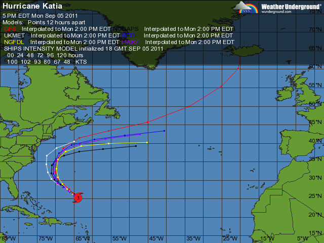
Nevertheless, the NAM model (upper right) is the only model that brings the storm close to New England. It also has Katia being a very strong hurricane at the time of her passage. Both of these scenarios seem unlikely. Katia will pass well west of Bermuda by Tuesday, probably as a category 3 storm, and she will appear to be heading for the Outer Banks of North Carolina.


As you can see, that is as close as she gets to land. By Wednesday, Katia will be picked up by the prevailing west winds of the jet stream and get pushed way out to sea. Our only side effects will be increased surf and rip tides all week as Katia stirs up the ocean. A near hit but we come out unscathed with this storm. Of course, there is another developing tropical system just exiting the coast of Africa as we speak. It is the peak of hurricane season for sure. 

In the near future, we can all expect to get very wet over the next few days. Now tropical depression Lee will continue to move northeast over the Tennessee Valley and become extra tropical. He will lose his name but Lee will still have plenty of rain.

By late tonight into tomorrow morning, we should be deep in the rain associated with that slow moving cold front. What's left of Lee will get picked up by this cold front and give us a second good downpour late Tuesday night into Wednesday. All of this rain and instability will be slow to move out of here as well. Expect tomorrow to be pretty much a washout and Wednesday and Thursday to have intermittent showers with some heavy downpours mixed in.

All in all, a pretty crappy week. Enjoy it!!