Let's jump in the way back machine to 1999. Where were you on September 16th of that year? If you were in Boston, chances are you were hunkering down for Hurricane Floyd.
 Floyd was born on September 7th 1999 and took a very similar path to Irene trough the Bahamas. In fact, Floyd's eventual path ended up looking very similar to what forecasts are calling for Irene to do.
Floyd actually became a category 5 hurricane while over the Bahamas and as he approached the eastern seaboard, hurricane watches and warnings were put up at some point from Florida City, FL to Plymouth, MA. President Clinton even went so far as to declare state of emergencies in Florida and Georgia before the storm even made landfall. At the time, Florida was just 7 years removed from the devastating hurricane Andrew. Andrew had also developed in a very similar manor and area as Floyd.
In a mere 24 hours, Floyd went from a category 1 hurricane with maximum sustained winds a 95 knots to a high end category 4 hurricane with maximum sustained winds at 135 knots. In this time period, the central pressure of Floyd dropped 40mb! That is some rapid intensification. Later, in their follow up report of Floyd, the National Hurricane Center attributed this rapid intensification to " the presence of enhanced upper oceanic heat content along its track."
Take a look at the current sea surface temperatures for the Atlantic.

Notice the pool of super heated water that Irene is about to travel over, just east of Florida. This is the same type of situation that allowed Floyd to rapidly intensify. Expect Irene to follow a similar intensification pattern, although she will likely fall short of a category 5.
The next glaring piece of similarities between Floyd and Irene has to do with the projected and eventual path.
As is the case with all tropical systems in the far Atlantic, each storm travels almost due west, riding along the equator and using the prevailing easterly flow to direct its travel. Once these storms enter the Caribbean, they begin to interact with the westerilies or the west trade winds. This ultimately begins to curve the storms into a more north westerly path and then ultimately a north to north easterly path. It is called the storm re curvature period and it has a direct impact on where a hurricane will make landfall if it does at all.
The 500 mb level of the atmosphere is the steering wheel of our atmosphere. It is here where wind direction, troughs and ridges (heights) influence how intense a hurricane will get and where its path will be. The National Hurricane Center had this description of the 500 mb profile that lay in front of Hurricane Floyd,
"As a mid- to upper-tropospheric trough over the eastern United States eroded the subtropical ridge over the extreme western Atlantic, Floyd continued to turn gradually to the right. The center of the hurricane paralleled the central Florida coast, passing about 95 n mi east of Cape Canaveral around 0900 UTC 15 September. By the afternoon of the 15th, Floyd was abeam of the Florida/Georgia border and headed northward toward the Carolinas."
I realize that this explanation is a bit technical. What this statement essentially says is that sinking, drier air to the north and east of Floyd began to dig in behind and to the right of the storm. Combine this with the interaction with the westerlies and you have a hurricane that starts to turn right, just like Floyd did.
Take a look at this predicted 500 mb steering patterns for Irene
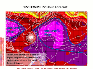 Again, I know this map is a bit technical. Credit for the map and description goes to Phils Tropical Weather Blog. What this (a bit outdated) model shows is quite similar to the steering patterns for Floyd. A strong ridge of high pressure over the atlantic along with strong high pressure over the mid west. In between these two ridges, little short wave troughs ( upper level storms) will continue to move south eastward from Canada. One of these shortwaves will interact with Irene, much like Floyd began to interact with a quickly moving cold front back in 1999. Think of that narrow path between the two high pressure systems as the "cone of uncertainty that you often see with projected hurricane paths.
So, since we can see that Floyd has two very strong similarities to Irene, what ultimately became of Floyd and his impact with New England? This is where I begin to preach caution with anyone getting ahead of themselves with a doomsday prediction. Floyd was ultimately a bust as far as New England was concerned.
He eventually made landfall in extreme eastern North Carolina on September 16th and brought historic and deadly flooding to that whole state. From there, despite hurricane warnings begin posted all of the way to Plymouth, Floyd began to weaken rapidly, as most hurricanes do when they interact with land and colder water.
 Floyd tracked just to the east of NYC and to the west of Boston, ultimately losing his strong winds but maintaining his heavy tropical rainfall. Looking at the final rainfall totals below, you can see the outrageous amount of rain that fell to the west of the storm. With hurricanes, the heaviest rainfall is always of the western side of the eyewall while the strongest winds lie on the eastern side.
Boston would have been in line to see the strongest winds from Floyd, but he was just barley a tropical storm by the time he got to us on the 17th. We saw our fair share of rain (nothing like North Carolina) but the threat of a catastrophic land falling hurricane for Boston just didn't pan out.
Will this same result happen with Irene? It is impossible to say at this point. Emotions will likely be running high in our region with the threat of a major hurricane. Emergency preparations should certainly be taken and all citizens should be watching for updates on Irene. Just remember that hurricane tracks are EXTREMELY hard to forecast. Probably one of the most difficult things a meteorologist has to do.
Right now, Irene looks like she will stay over water and make landfall as a major hurricane in Southern New England. Back in 1999, Floyd had the exact same expectations and we saw what happened there. Sometimes in these types of scenarios, historical patterns should take precedent over emotionality charged assumptions.
I will have more updates on Irene later tonight.
No comments:
Post a Comment