Luckily, it is all about to change. And unlike the movies, (like the Perfect Storm which I watched last night) our pattern change will not be dramatic and feature a unshaven George Clooney.
My pal Joe Bastardi of Accuweather pegged January 15th as the date when the upper level air pattern over North America would change and allow for the winter season to finally begin and it appears as if he is going to be dead on.
Tomorrow night, a storm will approach us from the south and will reform off the eastern seaboard. While we should all be initially cold enough to start out as snow, eventually our prevailing winds will shift to the east and northeast, creating an ocean front and changing pretty much all of SNE to a mix and then rain. As a side note, the snow starved mountains of Northern New England should see a good 6-12 inches from this storm and another one on Friday.
Some of you may be asking yourself, why did I read 3 paragraphs just to hear Greg tell me that we are getting more cold rain? Its probably because you have nothing better else to do. Kidding! It's actually because what falls on Thursday is meaningless. Of actual importance is two crucial changes that will occur on Friday.
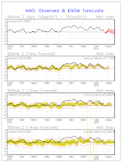
1.) A negative NAO! If you are avid reader of this blog, and who isn't really, you may remember me bitching and moaning about our lack of a negative NAO back in November. I won't repeat all of the details again but just note that this climate feature is CRITICAL in both locking in cold air over New England and altering the jet stream to allow for more coastal storms.
 Boom. There is the image that made me literally scream for joy yesterday. Blocking over Greenland is good news for snow lovers.
2.) A weakening La Nina. La Nina is finally changing to a neutral pattern. What does this mean? Well, the second half of January and first half of February is going to be COLD for the Great Lakes, the Plains and the Northeast. That first cold air will arrive on Friday night and with blocking finally starting to develop (see above), it is here to stay. I wouldn't expect anymore 50 or 60 degree days anytime soon.
A mid winter La Nina change also has some interesting past February trends attached to it. Winters that start out snow less and warm and then suddenly change in mid January have seen some pretty big early February storms. It is way to early to say that we will get a big snowstorm in February but just know this. The pattern change has occurred. Be forewarned, cold air and snow will follow. I fear most people who have been writing this winter off are going to be in for a rude awakening over the next few weeks!
No comments:
Post a Comment