Ok, now onto the weather! Or really, the lack of weather. November continues to remain extremely warm. We have had 12 days of 60 degree weather, making this the 2nd warmest November on record with temps running an average 5.4 degrees above normal. Interstingly enough, we likely won't top the warmest November on record, 1975, which had temps running over 7 degrees warmer than average!
One thing that is noteable about the top 5 warmest Novembers, including our current month, is the lack of snowfall for the remainder of the winter. I am starting to believe this winter will be no different.
So why the lack of cold air? To make a food reference (since Thanksgiving did just pass) we are missing some key ingredients.
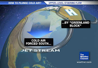
1.) The Greenland Block -

This is a crucial piece to maintaining cold air over the east coast. As you can see from the image to the right, a typical high pressure over Greenland sets up a blocking pattern in the Northern Atlantic, allowing cold air that has been building up over the Hudson Bay to move south and stay locked in for several days. This whole process is part of a bigger process called the North Atlantic Oscillation but I won't get into that as it is confusing and boring to read about. Just know this, no Greenland High means that cold air may come and go, but it won't stay for more than a day or two.
2. Irregular Jet Stream- You should know that the jet stream is what drives our weather and air masses. If you have been watching the news over the past month, you probably have heard about other abnormal weather occurances happening all over the country. This is due to an irregular pattern for the fall. This image is a good visualization of what is refered to as a negative PNA which has been our reality for many weeks. The Northwest and even California are contiually being pounded by storms while we here in the Northeast have been tapping into the warm Gulf temperatures, keeping us unseasonably warm and dry.
Of course, there are other factors that play into this. A weaker than predicted La Nina is the likely culprit of this abnormal set. What this has led to is a very progressive and warm atmosphere for us. Storms and air masses have been moving very quickly, followed by strong winds the day after. But in between, we continually see west to south west flows with 50-60 degree readings and sunny skies.
The abnormal (netative PNA) jet stream set up is showing signs of breaking down over the next few weeks, which should allow colder air to "break away" and move into our area. But with no blocking in place, our atmosphere remains very progessive. Typically this will mean more seasonable weather but no big storms.
Regardless of the reasons, I know everyone is enjoying this warm weather. Even I am liking it, despite my love of big snow storms but I would be lying if I said that I didn't want a nice 2 foot snow storm for Christmas!

No comments:
Post a Comment