Thursday, July 29, 2010

So Many Sharks!


No wonder. Our ocean temps are averaging a good 2 to 4 degrees above normal. Specifically in Falmouth, Chatam and south facing beaches.

Woods Hole current sea temperature 74. Normal for July 29th 72.

Bo
ston current sea temperature 69. Normal for July 29th 67

Two degrees is a lot for the ocean. Sharks sure do like warm water. So do Hurricanes.


Tuesday, July 20, 2010

No Tornado

From the NWS......

...THERE WAS NO TORNADO IN WORCESTER COUNTY ON JULY 19...

A NATIONAL WEATHER SERVICE TEAM SURVEYED THE TOWN OF ASHBURNHAM
ALONG WITH ADJACENT PORTIONS OF WESTMINSTER AND GARDNER TODAY.
VERY LITTLE IN THE WAY OF DAMAGE WAS EVIDENT FROM THE STORMS THAT
MOVED THROUGH THAT AREA YESTERDAY AND THE CONCLUSION IS THAT NO
TORNADO REACHED THE GROUND.

Monday, July 19, 2010

I am back and there is a tornado warning!


Live from my new residence in West Roxbury, where my legs and arms are tired from moving and biking to work, but more importantly, there are some severe storms rumbling through our area tonight!

They may have taken all day, but it was worth the wait. Right now, there is a tornado warning our for northern Worcester county. The radar was showing some "very impressive vorticity and reflectivity images" as stated by the NWS at 7:30. No confirmation yet, but we will wait to see if a tornado actually did touch down! Here is the radar image.

No tornados for us here in Boston. The air overhead is too stable. Look for these storms to weaken as they get closer to the coast.

Monday, July 12, 2010

Welcome to Monday, Where I am Moving Shit All Day

After round 1 of my moving boxes from Somerville to West Roxbury, I am....
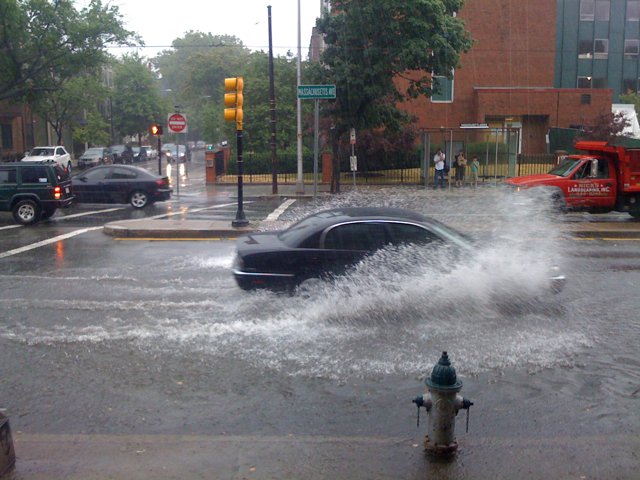
- Completely soaked after an early afternoon t-storm(more on that later)
- Sick of the radio, especially sports radio.
- Pissed that someone invented elevation and stairs.
- Appalled at how many freaking books and other items Katrina has.
- Intrigued by the day time crowds in and around the city. Freaks don't just come out at night.
- So close to getting my new phone! But then Sprint stepped in and fucked it up. Classic.
- Growing more and more happy with the decision to get an apartment with laundry in it.

That is all I got for observations. I was impressed with the storm that soaked me. I guess that easterly breeze was strong enough to cause some serious lift in the atmosphere and produce some nice downpours. Over a half inch in Cambridge. More elsewhere I am sure.

This instability is great. Reminds me of Florida. Humid and moist airflow everyday, clashing with seabreezes and topography to make for some true pop up thunderstorms. It's with us for the rest of the week for sure. Expect downpours at any time really.

That's it for me right now. I am eating lunch, being lazy, then off to round 2 of moving crap( mostly Katrina's crap)

Hopefully I will get my 5 day up again later today. I was having some technical difficulties last night.

P.S. If you can get to the beach, do it! Ocean temps are very warm right now, 70's pretty much everywhere. That is pretty warm for us in July! I would not be surprised if there are some more shark sightings with ocean temps this warm.

Sunday, July 11, 2010

What A Wet Saturday Afternoon

So yesterday was quite a show! Around 2:30 in the afternoon, some heavy rain moved into the greater Boston area and sat over us for about an hour. The atmosphere was VERY moist, almost 100% humidity. Combined with some very unstable air you get heavy downpours!

In Cambridge, where I was at work, 3.3 inches of rain fell in just under 90 min! Boston got 2.01 inches in the same time span. We hadn't had any rain here for the better part of two weeks so our ground soil was very dry and unable to absorb this amount of rain in such a short time. What you got was scenes like these.


Thank you to my friend Brian Blank for the pics. Crazy scene! I saw a little kid get swept off his feet by the strong current of water on Mass Ave. Some pretty serious flash flooding was reported all across the area. Once the rain stopped, the floods just disappeared. Makes you think though. If just 3 inches of rain could do this, what does 8 or 9 inches of rain look like!

By the way, our yearly total for precipitation is over 30 inches now! We still have 5 more months in the year as well.

Friday, July 9, 2010

Friday is here and I have the afternoon off

Moving sucks. Katrina and I are slowly packing up our things and transitioning to our new place. Most people say that having more time to move is a good thing, but I think it leads to more procrastination. All in all, I give moving 7 yucks out of 10.

So I have decided to scrap my website version of this blog for awhile. It is too much work to maintain both and lets face it, I have no idea how to build and maintain a website. I think the blog is good enough for now. I will build on some features here instead, like the 5 day forecast that I just posted! Go ahead and tell me it looks awesome. I know it does. Honestly, tell me anything. I am dying for comments. No one comments and it makes me sad.

But lets get to the good stuff! It sure is humid out today. As I write this, the temperature is only 91, but the dew point is 65. Dew points of course measure the amount of moisture in the air. 60s to 70s for dew points are just uncomfortable and the air feels heavy. We are not near our record temperatures of earlier this week, but if you ask me, more humidity is worse.

A slow moving cold front is going to impact our weekend. Ahead of it, we are stuck in the humid airflow from the southwest. This front is going to be a slow mover. Everything is a bit log jammed in our atmosphere right now, mainly due to the big high pressure ridge over the east coast. This front is the same one that basically ran into another stalled cold front over the mid west earlier this week. Now it is dragging its feet through our region.

The front never makes it to Boston on Saturday, but because of our warm and moist air, showers and heavy rainfall could really pop up at any moment in the afternoon. Either way, expect more clouds than sun as the day progresses. Overnight, more steady rainfall will move in with some chance for thunderstorms as well.

Until then, have a great day. I give this day a sweat factor of 8 out of 10.

Custom 5 day!!!


Wednesday, July 7, 2010

Nachos!!!!!!!

Sorry about the title. I just finished my nachos from last night for breakfast and now I am regretting it.

So I don't know about anyone else, but last night I could not sleep at all. It was too hot and I could feel the humidity too. Heat indexes were in the upper 80's to 90 degrees as late as midnight last night! That is not fun. Katrina was excited to have the bed all to herself, but Mr. Pink Nose was not happy that I disturbed him in the living room. I guess I just can't win.

Excessive heat will still be persistent in interior sections of the state today as well as in the mid atlantic region. Cities like Washington DC, Baltimore and Philly could easily top 100 degrees for the second straight day. For Boston? We have a nice onshore flow today that will keep us in the relatively cool 90's.

Our high pressure ridge begins to break overnight and cooler temps with higher humidity will follow.

Tuesday, July 6, 2010

100 Degrees!

In the midst of baby watching today, the city of Boston hit 100 degrees for the first time since 2002! The "expected" sea breeze never really developed. I knew we were in trouble when I left for work at 9:45 this morning and we were already at 91 degrees with a strong southwest breeze in Somerville. Still, 100 degrees for this city is a big deal.

Look for some relief tomorrow in the temperature department, but humidity will be on the rise as the week progresses.On a side note, how cute is my new niece Mackenzie??

Welcome to Tuesday, Where its Hot and I am an Uncle!!


Hottest day of the year? Check
Katrina angry that she is not at the beach? Check
My sister having her baby and me becoming an uncle? Check!

What a day. I hope most people are on vacation this week because it is going to be quite hot today as I am sure most of you are aware by now. The NWS has issued a heat advisory for pretty much all counties in the state. Suffolk county was a late inclusion in the advisory, trumping earlier thoughts that an afternoon seabreeze would keep temps down a bit.

Temperatures should easily reach 95+ today combined with dew points in the mid to upper 60's. This will make it feel like 100-105 degrees for several hours today.Yuck!

Stay inside if you can. No need to be a hero today. With our third straight day of 90 degree heat, we officially have our first heat wave of the summer. I am not sure we even got one heat wave last summer.

Humidity will be on the rise overnight, so uncomfortable sleeping conditions are expected. That means it is ok to sleep naked! Haha.

Tomorrow and beyond, we lost the hot temps somewhat, but we trade that off with higher humidity. Anyway you cut it, its going to be a hot week.

Make sure you visit my website! www.northeastweatherrants.com

Friday, July 2, 2010

The Heat Is On


Get ready New England. We are about to enter our first heat wave of the summer. And this one could be here for several days.

Tomorrow the transition begins. Expect temperatures to climb into the upper 80's with increasing humidity. After that, the heat parade begins. Our summer time buddy, the Bermuda High, slips a little further west over the next few weeks, driving the northern jet stream way up into Canada and keeping us in a very warm and humid south, southwest flow. This pattern, much like cold air patterns that we get in the winter, will be tough to break and we are looking at temperatures in the mid to upper 90's, even in Boston, for pretty much all of next week. Obviously, things can change later in the week, but expect 90+ degree heat with humidity starting July4th and lasting through Tuesday. This much I can promise you.

This heat wave will not be pleasant. Humid conditions will make it unbearable at times. The mid atlantic big cities could get the worst of it, with temps hitting 100 degrees likely in DC and even Philly. At least we won't get that hot. Try to stay cool!

July Snow!!!


Check out this picture from Mt. Washington this morning!

Our cool air mass the past few days really had an extreme effect on top of the 6000+ foot mountain. Morning time temps in the mid 30's allowed for a dusting of snow to fall up until about noon today. Pretty stark contrast to our weather down here and even more of a contrast to what is coming. At 35 degrees, Mt. Washington holds the distinction of being the lowest temperature recorded in the lower 48 today.

Thursday, July 1, 2010

June Data

Average Daily Temp 70.3

Departure from Normal 2.3

Highest Temp 94

Lowest Temp
53

Total Precipitation for Month 3.18

Total Precipitation for Year 28.98

Departure from Normal 7.85