Our storm is pulling away slowly as we speak, and it will bring an end to our second wettest month ever. Some highlights (or low lights)
- Yesterday's storm gave us just over 4 inches of rain in Boston, upping our annual total to 21.08 inches of rain. That is a staggering 10 inches above normal values!!
- We are not even in April yet and we have already received over half of our total annual average precipitation of 42 inches.
- At Blue Hills observatory, where they have been keeping weather data for the longest period of time in all of New England, March 2010 will go down as the wettest month EVER at just over 18 inches of rain.
- Severe river and stream flooding will be happening today as cresting stages reach their max height. Some of the worst flooding is down by the RI/MA border and in Cranston, RI where the Pawtuxet River will reach a flood stage of 21 feet. The previous record was 15 feet!
- This was not just abnormal for humans. Take a closer look at how some animals are reacting to all of this rain. Birds are having a feast today as worms escape the over saturated ground.
That is all I have for now. A big warm up is on its way, starting tomorrow and lasting through the weekend. We definitly deserve it.
Congratulations to Kelly and Brian for getting the news that they are expecting a girl! That's two nieces on the way now!
Wednesday, March 31, 2010
Tuesday, March 30, 2010
It's Official
As of 1pm today, this month became both our wettest March ever and also our second wettest month ever with a total of 13.63 inches and the rain still falling.
Records are falling all around southern New England including monthly records set in Providence, Hartford and Worcester. And the rain is still falling.
These 3 storms that we have had in the past 3 weeks have been quite historic to say the least. This is still considered our "cool season" and rainfall like we have seen is very rare this early into our spring pattern.
What does that mean for the rest of the season? I have no idea. Usually, despite the atmosphere being a dynamic fluid system, things tend to even themselves out after an abnormal event. That will certainly be the case later this week as we tap into some very mild and more importantly dry air. More on that later.
For now, all eyes turn to rivers, streams and basements. The rain may have lightened up, but the serious flooding has yet to begin.
Monday, March 29, 2010
Rainfall Expectations Increased
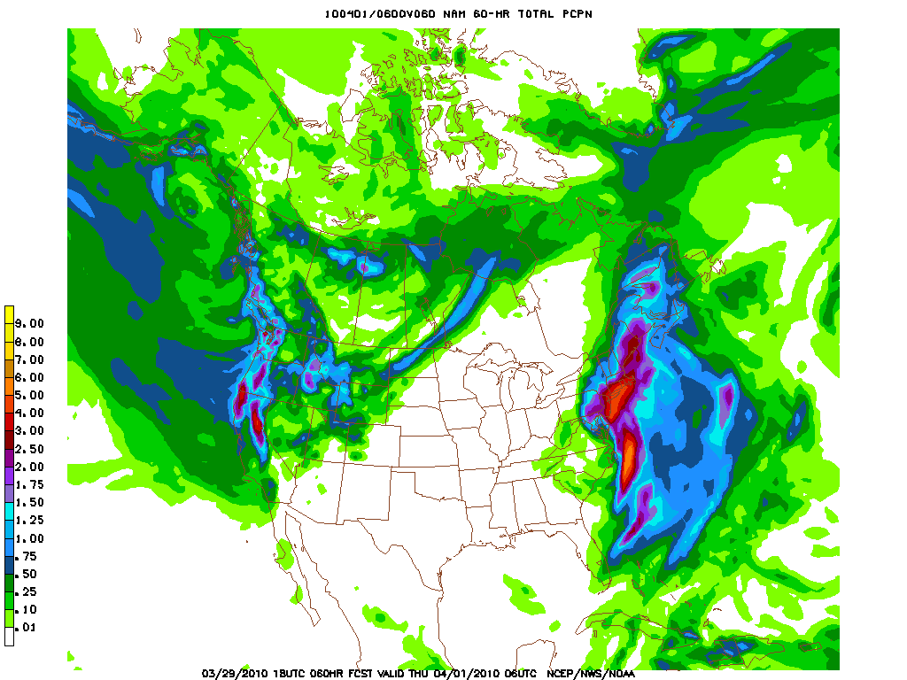
Based on the most recent data, the NWS has upped the total expected rainfall to 4-6 inches with isolated areas of 8 inches very likely. The axis of heavy rainfall has shifted eastward. This is not even the worst of the rain.
Later on tonight, as the jet stream shifts to an easterly flow triggers the rainfall explosion. An extremely wet atmosphere combined with an endless supply of tropical moisture from the ocean will set up a torrential rain event for the better part of 6 hours. This strong easterly flow will enhance the rainfall right along the coast even more so as a coastal front will likely set up. Any way you cut it, Tuesday morning will be very wet and very dangerous.
Major flooding is expected, the likes of which have not been seen in decades. Pretty much every river and stream will likely overflow, some worse than others. Again, the ground is still very saturated so expect areas that received flooding two weeks ago to flood again. This could happen even quicker than before as the time period for the heaviest rainfall is much shorter than the last storm. What that means is we will see the same amount of moisture a lot faster.
In addition to major flooding, several records will fall including the wettest March on record.Some of these records have stood for close to 70 years! As it stands now, we have received 10.92 inches of rain this month. The next measurement will likely break our all time March record. The all time record is 17.09 inches back in August of 1955 and that was mainly the result of two hurricanes that hit the area. 17 inches is unlikely, but I am almost positive that this month will end up as the second wettest month ever in Boston.
Exciting stuff for weather geeks, but I also recognize the significant damadge this will cause. Be advised, move all valuables from basements and keep an eye on rapidly rising water. We are not very used to seeing this type of rain around here, so flash flooding can happen in areas that people do not expect to see any flooding at all. Do your neighborhoods a favor and try to clear out debris from storm drains so the water can flow smoothly. Overnight tonight and early tomorrow morning will be the best chance for flooding. Stay safe!
It Begins....
Our latest storm has arrived slowly, with the promise of very heavy rain overnight tonight and especially tomorrow morning.
For the immediate future, expect light to moderate rainfall to continue all day, with wind gusts topping out at 40 mph, but for the most part staying in the 20-25 mph range. Rain bands will continue to shift eastward, in from the ocean, as one look at the radar shows a long line of rain extending all the way down the east coast and along this essentially stationary cold front.
Then the real fun begins. As the storm slowly moves up the coast, we will find ourselves under the influence of some pretty heavy subtropical moisture. Translation, torrential rainfall. This looks to happen sometime overnight into early morning tomorrow. Totals in a 6 hour window could reach up to 6 inches. That is a tremendous amount of moisture in a small period of time. This is the period where I would expect the most serious flooding to occur.
Storm totals still look to be about 3-4 inches with some areas getting close to 7 inches, depending on where the heaviest bands set up. These rain bands will be reminiscent of hurricane rain bands, as they continue to rotate heavy rainfall and gusty winds into the area. Obviously, winds won't reach hurricane levels, but they will be quite gusty as the storm intensifies and really wraps into a tight circulation. By the end of this storm, Boston could end up with its 2nd wetest month ever!
I will post more on the storm later. Stay dry!
Sunday, March 28, 2010
Monday Brings More Rain

First off, my apologies on my lack of posts this week. Between people visiting, birthdays happening, working like crazy and of course my all important fantasy baseball draft, I have been lacking with my blog. I love doing this blog and I need appreciate all of your support so keep it coming!
Now onto the story. The picture above tells the whole story. A lot of rain is coming again and this time it will cause widespread moderate to severe flooding again for our region as well as officially break our record for the rainiest March ever on record.
Here is how it breaks down: A low pressure system from the Ohio Valley transitions into a large coastal storm, very much like a noreaster would. The problem is, this storm follows the pattern of many of our other storms this year and becomes "cut off" from the jet steam. Essentially, this means that the storm will sit and spin to our south, tapping into a very strong low level jet steam and drag Atlantic moisture into Boston, bringing us another monster rain storm. Winds will pick up as well, Monday nights gusts could be over 45 mph, especially on the coast.
This is no joke. Expect 3-6 inches of rain to fall starting late tonight and lasting into Tuesday when scattered showers should take over for drenching rain. Monday looks to be a complete washout and there are serious concerns for flooding only two weeks removed from our 7 inch rain storm which caused some pretty significant flooding itself.
The NWS is warning people to take precautions and I would listen if I were one of the many people that had basements flood with the last storm. As I said before, that water had nowhere to go. These warnings don't just pertain to rivers and streams. Significant urban flooding is expected as well, as sewers and other draining devices have been overloaded this month.
I will have much more as the rain begins to fall, but for now, keep an eye on the sky and also beware of rising water. The storm looks to be out of our hair by Wednesday and I can guarantee that you will all like the forecast for this weekend. Do you like 80 degree temperatures?
Wednesday, March 24, 2010
Enjoyable Two Days

Today ended up being pretty reasonable albeit windy. Some pretty strong gusts too, upwards of 35mph.
Tomorrow is definitely the pick of the week. Southwest winds bring us close to or above 60. But it doesn't last.
Rain moves in late Thursday night. A cold front is to blame this time around. It will be showery rain, not drenching and it should be over by mid day but there will be some big changes in store. Temperatures drop drastically behind the front. High temps should occur in the morning as temperatures will eventually settle in to the 30's and drop even lower Friday night.
I wish I knew where I put my gloves. Go celtics!
Tuesday, March 23, 2010
More Rain

Yuck with a capital Y! I know I did not like seeing the rain this morning. Especially when I was considering walking down to Davis Square. Screw that idea. Now its the 87 bus for me. And today is going to be one of those days where the bus is crowded, everyone is wet and people are full of bad attitudes.
Anyways, we are in for another water filled event. Heavy rain should last throughout the morning and into the afternoon as our storm gets some nice tropical moisture feed from the Bahamas. I bet the weather is nice down there.
Storm totals will be nowhere near the last storm, but we are still going to see 2+ inches of rain out of this storm. Add that to our seasonal totals and we are talking about flooding again. Anyone living along rivers or in low lying areas, expect this to be the norm for pretty much the rest of the spring.
The storm should be out of here by tomorrow. Could see some windy conditions for awhile as the storm pulls away. Thursday is shaping up to be the pick of the week. Upper 50's to low 60's for temps. And then the bottom drops out. Friday, our good friend cold comes back for a visit. It will feel like the end of January, not the end of March.
Stay dry people. Follow Katrina's lead and just moan and whine out the window until the rain goes away.
Saturday, March 20, 2010
Unbelievable Weekend. Back to Earth Monday
Lets get right to it. This stretch of weather we've had the past 4 days has been magnificent, topped off by a glorious Saturday where the temperature reached 72 in Boston and Providence. We have not seen this type of extended warm weather in March since 1998! So what does this tell us? Unfortunately it means that this is simply not normal for us and it has to end soon.
Despite today being the first official day of spring, the sun is still not strong enough to warm us up on a consistent basis. Our excellent weather for the past few days was due to us being on the beneficial side of a strong High Pressure system to our south, keeping us locked into a warm southwesterly flow of air and a strong flow at that. Typically areas close to the coast really feel the effects of the sea breeze during these abnormal warmups but not so this week. I was amazed at the amount of people who seemingly emerged from their winter slumbers these past few days. I think this stretch of weather really did a lot of good for peoples mental state, especially after our ridiculous rainfall the previous weekend.
Ok. I have given you all two full paragraphs about our warm weather. You know the dagger is coming and that dagger is a pesky cold front that looked like it might stay away from us earlier in the week but no such luck. With that passing front comes the end to our party and winds should shift around to a northerly flow keeping us noticeably cooler tomorrow. Boston may not even get out of the upper 40's.
From there it only gets worse. Another rain storm moves in from the midwest on Monday night into Tuesday. Certainly nothing like last weekends storm, but as I mentioned before, any rain at this point is bad news. We are way over our normal values for precipitation and with this storm looking to bring at least another inch of rainfall to the area, expect more flooding to occur. This will especially be the case for our swollen rivers and low lying areas.
Want more bad news? Long term forecasts show us getting a pretty good shot of cold air from Canada just in time for next weekend. I am talking about high temps in the upper 30's with lows in the 20's. Think of it as old man winter's last parting shot. Take my advice. Do not put away your winter coats yet.
Tuesday, March 16, 2010
Here comes the sun!
Our storm is finally gone and our friend the sun is back! With it's arrival, we will see temps jump into the mid 50's today and only climb higher as the week goes on. Still, a massive rain storm overall that we just had. Some of the final totals.
WOBURN 10.33
TOPSFIELD 10.13
CAMBRIDGE 8.32
BOSTON 6.98
I spoke too early yesterday about the lack of flooding. Turns out that there has been some serious flooding in the aftermath of this storm. Here is a link to Boston.com's photos of the flooding in the area (http://www.boston.com/news/local/gallery/031510_storm_flood_photos/) Some pretty crazy scenes.
We are at 13 inches of rain for the year which is 5 inches over where we should be! There will be no drought this spring. Expect the leaves and flowers to grow and spout on time this year.
And to now for our grand prize. Beautiful weather is with us for the next 5 plus days. You should really get out there and enjoy it. We are the benefactors of a high pressure system in the southeast giving us a nice southwesterly flow of air all week giving us clear, calm and warm weather.
Enjoy it!
Monday, March 15, 2010
It just keeps coming
Official rainfall total in Cambridge as of 5:30 tonight is over 8 inches of rain. Crazy! That is nearly 18% of our annual precipitation total in 3 days!!
Boston has received almost 7 inches.
We have certainly made up for the lower totals the I posted yesterday. The models were calling for these amounts but they were hard to believe. Looks like they were right all along.
Flooding is obviously a concern but I wouldn't expect too much beyond some rivers and streams overflowing and big puddles causing headaches. If we get another rain storm in the near future however, flooding will be much more of an issue as all of this water will have nowhere to go.
Rain Totals So Far
Greg is up late working on Physics because he ran the Ras 5K today and then proceeded to drink many beers afterwards and rendering himself useless for anytime before 9pm tonight.
Nevertheless, it was a good time but very, very wet. Speaking of being wet, here are the wetness totals so far as collected by the NWS.
MASSACHUSETTS
...BARNSTABLE COUNTY...
EAST FALMOUTH 2.70
FALMOUTH 2.69
YARMOUTH 2.41
BREWSTER 2.05
...BRISTOL COUNTY...
TAUNTON 4.01
TAUNTON 3.56
ACUSHNET 3.54
MANSFIELD 3.46
NORTON 3.31
PLAINVILLE 3.21
WEST MANSFIELD 3.06
REHOBOTH 2.97
NEW BEDFORD 2.96
ATTLEBORO 2.60
BERKLEY 2.60
...ESSEX COUNTY...
IPSWICH 4.11
METHUEN 3.07
SWAMPSCOTT 3.05
PEABODY 2.95
LAWRENCE 2.60
LYNN 2.05
...FRANKLIN COUNTY...
ASHFIELD 2.23
...HAMPDEN COUNTY...
GRANVILLE 2.31
...HAMPSHIRE COUNTY...
WORTHINGTON 2.64
...MIDDLESEX COUNTY...
READING 4.14
ARLINGTON 3.82
WALTHAM 3.78
CONCORD 3.72
WAKEFIELD 3.69
BEDFORD 3.54
WESTFORD 3.26
STONEHAM 3.09
PEPPERELL 2.95
BELMONT 2.13
FRAMINGHAM 2.13
CAMBRIDGE 2.00
...NORFOLK COUNTY...
WALPOLE 3.78
DEDHAM 3.67
MEDFIELD 3.65
EAST MILTON 3.23
EAST MILTON 3.17
FOXBORO 3.17
PLAINVILLE 2.88
NORWOOD 2.62
...PLYMOUTH COUNTY...
HALIFAX 4.06
WAREHAM 3.62
HINGHAM 3.57
WEST BRIDGEWATER 3.50
PLYMOUTH 3.34
BRIDGEWATER 3.27
ROCHESTER 3.12
MIDDLEBORO 2.93
...SUFFOLK COUNTY...
EAST BOSTON 2.63
...WORCESTER COUNTY...
UXBRIDGE 3.19
SHREWSBURY 2.95
ASHBURNHAM 2.85
HOLDEN 2.80
NORTHBRIDGE 2.58
WORCESTER 2.47
MENDON 2.41
FITCHBURG 2.39
CHARLTON 2.38
GRAFTON 2.04
Some of these totals are a bit old, so expect to see higher numbers by the end of this, but a good range of 2-3 inches of rain for all of us. A bit lower than expectations but that still is a lot of rain in a small period of time and we are not done yet. Widespread reports of minor flooding.
Our storm is still sitting 80 miles south west of Nantucket moving sloooowly to the east. This slow movement keeps us in the rain for one more day. Expect a constant drizzle to moderate rain all day. Locations over 1000ft will see some wet snow towards the end of the day, as the storm pulls in some cold air.
There is a big pay off for all of this rain. Very nice weather next week starting on Tuesday lasting into the weekend. With every model run, the high temps keep increasing. Could be looking at some 60 degree readings! Hang in there. Just one more day.
Lastly, the NWS mesoscale site (http://w1.spc.woc.noaa.gov/exper/mesoanalysis/new/viewsector.php?sector=16&parm=pmsl#) gives awesome real time info for all kinds of variables. Great tool for storms like this one.
Saturday, March 13, 2010
Get those duck boots on.

In case you are color blind, this latest NAM forecast map shows us getting 3-4 inches of rain in the next 24 hours. Yikes.
The model is most likely a little high on the totals, but 2 inches is a sure bet with higher amounts likely in many areas.
A look at the current Radar (http://radar.weather.gov/Conus/northeast_loop.php) and you can see what is on the way. Heavy rain has already forced a delay in an A10 basketball game in Atlantic City because the roof was leaking.
In any event, this storm is no joke. Sure its not a snowstorm and therefor not as sexy, but it is large, wet and is about to stall out right in our sweet spot, aka just of the Jersey coast. The jet steam is going to dip petty low in the atmosphere, meaning we are going to get some strong winds starting overnight and also meaning that the general flow of the atmosphere is going to stop and hence trap our storm from moving anywhere for the next 48 hours.
Rain is going to be heavy and winds will be strong. The rain totals for this storm are going to be ridiculous. As I said above, most models are calling for 3-4 inches of rain in 24 hours and 4-6 inches in 48 hours. Not sure how much we can believe this, but if the reality is anywhere close to this, expect some urban flooding (ie: huge puddles, basements flooding, roofs leaking). No matter where you live, this much rain in this little of a time period spells trouble.
Most people remember the May 2006 3 day storm where the North Shore received 8-15 inches of rain and had severe flooding. I don't think we will see that level of flooding but some areas could get about 8 inches of rain and most will see at least 3.
On a personal note, Andy and I are suppose to run the Ras 5K tomorrow. It is not going to be fun. At least this is the perfect weekend to work on a stupid Physics take home test.
Positive signs for the future. After this mess clears out by Tuesday, expect to see the sun and some pretty warm temps (upper 50's) for the remainder of next week.
Wednesday, March 10, 2010
High Pressure Galor!
With the excellent weather we have been having lately, soon to be interrupted by rain and terribleness, I thought I would take some time to give a quick explanation of what exactly a High Pressure system is. Or as Katrina likes to point out, the H for happy weather.
Let's start with recent forecast discussion from the NWS regarding the upcoming transition from nice weather, to stormy weather.
"THU/THU NIGHT...
MID LEVEL RIDGE BEGINS TO MOVE ACROSS THE REGION WHICH RESULTS IN
FLOW TRANSITIONING FROM ANTICYCLONIC TO CYCLONIC FROM WEST TO EAST.
Lot's of technical jargon in here, which I actually dislike about the NWS weather discussions but nevertheless, lets focus on the first sentence.
When we talk of ridges, we are referring to a large area of High Pressure. So what the hell is high pressure? You can actually take the term literally as a matter of fact. A high pressure system, or in this case ridge, is an area where the atmospheric pressure is higher than surrounding areas. The air in a high pressure system is more dense and begins pushing downward towards land, accounting for the higher pressure we feel. Well, not really feel, but see.
Air flowing down from the upper atmosphere is the exact opposite process that occurs when a storm is forming. Most of us know that clouds and precipitation occurs when air rises and then cools and condenses to form clouds. Sinking air is unable to form condensation in such a manner which is why we usually see clear skies with high pressure.
Another important property of high pressure has to do with the direction that air flows when it reaches the ground. Because of the earth's rotation and land friction, the wind from a high pressure system actually flows outward, away from the center unlike a storm or low pressure system in which we know that the strongest winds are close to the center and flow counterclockwise. These flow distinctions give both a high pressure and low pressure the terms of anticyclonic and cyclonic flow respectively. Anticyclonic flow will never be able to form clouds which is why high pressure is a good indicator of fair weather.
Of course, there is a lot more detail that goes into this process, but at least this gives you somewhat of an understanding as to why those H's on the weather maps mean happy weather!
Monday, March 8, 2010
Beautiful Today, Heavy Rain on the Way

What a day today! Even warmer than yesterday. Temperature in Boston reached 60 today and it felt even warmer. 60 degrees after winter weather for several months always feels warmer. We were lucky this past weekend.
Usually, these late winter/early spring warm ups are not as nice near the coast because of the wind off the water, but yesterday and today's strong southwest winds completely blocked any cooling by the ocean.
A cooler wind follows a cold front that moves through tonight, with our air for the next few days flowing from the colder northwest. It will be cooler, but still very reasonable for early March with highs in the mid to upper 40's on Tuesday and Wednesday and plenty of sunshine as well. Clear nights for some good star viewing too!!
Thursday is our day of transition. We have made a deal with the weather devil. In exchange for our awesome weather this past weekend, we can expect miserable conditions for the upcoming weekend. No snow, as we just don't have any cold air around, but all signs point to a very big and extended rain storm. Just take a look at the map above and you can see what lies in the future for us. 2+ inches of rain in 48 hours starting on Friday. Yuck.
The culprit will be another ocean storm that gets sucked back to the west by another cut off upper level low over the midwest and a big blocking high pressure system over the Atlantic. This will mark the third storm that has behaved this way in the past month. What gives? I am not really sure to be honest. It's a bit above my knowledge level and to tell you the truth, a bit above anyone's knowledge level when it comes to the atmosphere. You would be surprised at the limit of understanding that we have about the weather, even with all of those fancy radars and phone applications. It remains a very complex science to pin down.
Anyways, I am done ranting about how hard it is to predict weather. I am sure there are a lot of sympathetic ears out there. I leave you with this thought:
Have you noticed how the media is all hyped up on earthquakes right now? Granted, there have been two huge ones in the past few weeks, but where was this coverage before? I hate to break it to you people, but earthquakes happen at astonishingly regular intervals and most of them are hardly news worthy. I am going to take advantage of this hype and call in a false earthquake alarm to Fox 25 and see if they bite.
Sunday, March 7, 2010
As Promised, Astronmony Section is Here
The Sky At A Glance
Daylight Saving Time begins in most of the U.S. and Canada at 2:00 am on Sunday, March 14. Move clocks 1 hour forward, so 2:00 am becomes 3:00 am.
The March Equinox occurs on March 20 at 1:32 pm EDT. The Sun crosses the celestial equator on its journey north, marking the official beginning of spring in the Northern Hemisphere and of fall in the Southern Hemisphere.
Phases of the Moon
Last Quarter Moon March 7
New Moon March 15
First Quarter Moon March 23
Full Moon March 29
Evening Planets (after sunset)
* Mercury, W
* Venus, W
* Mars, SE
* Saturn, E
Visible at Midnight
* Mars, W
* Saturn, SE
Morning Planets (before sunrise)
* Saturn, W
* Jupiter, E
Sunday Storm??

After beautiful weather early in the week, storminess returns on Thursday through Sunday. You really should enjoy this weekend because it is very likely that late winter and early spring will be filled with unsettled weather and cool temps. Its just the way it is around here.
Anyways, the above image serves as nothing more than a hype picture. It is a model run from yesterday that shows a huge winter storm affecting our area next Sunday. Obviously, this means little at this point, but part of the love hate relationship the public has with weather and weathermen is storm hype. So let the games begin!
Either way, bad weather returns on Thursday. Two storms in 4 days. The first one will probably start Thursday night into Friday and take the shape of the last few storms we have had. That is, cold rain at the coast and some snow/rain mix at higher elevations.
The second one is the one to watch. Long time between now and then, but plan for a much worse weekend next week. Sucks for those of us participating in the Ras Na Heireann 5k next Sunday, but good news for those of us who have a physics test to study for.
What a Day!
High pressure galore! Beautiful weather for today and tomorrow. Highs in the mid 50's and plenty of sunshine.
Cold front brings temps back to normal on Tuesday and we have a shot at some storminess late week.Long term forecasts show us getting back into a stormy pattern but I think we are going to be lacking some cold air, especially at the coast but I will have more on that in another post.
On a side note , I want to start an astronomy section on this blog so because I am president and CEO of this blog, I get to make these decisions. So be on the look out.
Wednesday, March 3, 2010
Soooo Close!


The above images are from the latest NAM run and you can see that we justtttttt miss the heavy stuff as far as precipitation goes. It's getting beyond frustrating now with these storms.
Cape Cod and portions of the South Shore will actually get a decent sized snow storm with totals ranging from 3-8 inches. Some areas on the outer Cape could even be over 8 inches.
In Boston, 1-2 inches at most. It won't even stick until after the sun goes down.
On a side note, the Boston Public Library is an interesting social fishbowl. At one table, I saw an obviously drunken man on the verge of passing out onto his book on day care! You can't make that stuff up.
Another Near Miss
Seems to be the story of the winter. BIG ocean storm is forming down around Virginia as we speak. As with every storm this winter, it will move almost directly eastward and then to the north, leaving us with a glancing blow.
This storm is quite big and it will slow down once it moves closer to New England. Because of these reasons, we will get a decent chunk of precipitation thrown back our way.
Light stuff during the daytime. The storm is still far south so don't expect anything beyond some light rain and snow for now. Our temps at the surface are too warm for snow to stick, but the air just above us is pretty cold, so if you get a stronger burst of preicip, it will probably fall as snow and just stick to grass and cars.
Tonight, our temps drop and the storm gets bigger and moves closer. Translation, accumulating snow. I would expect generally 1-3 inches in the Boston area, but more down on the South Shore and on the Cape. The snow showers stick around through Thursday as the storm slows its movement.
That's it for now. I am very sore from Pilates last night. That shit hurts.
Tuesday, March 2, 2010
Weather Picture of the Day

A spectacular thunderstorm reaches the mature state in June 2005 in York, Nebraska. Notice how the top has reached a point where it cannot contiue verticle growth and has begun to spread out, creating a flat top.
Monday, March 1, 2010
Totals for February
WEATHER OBSERVED NORMAL DEPART
VALUE DATE(S) VALUE FROM
NORMAL
................................................
TEMPERATURE (F)
RECORD
HIGH 70 02/24/1985
LOW -18 02/09/1934
HIGHEST 50 02/20
LOWEST 14 02/07
AVG. MAXIMUM 38.6 38.7 -0.1
AVG. MINIMUM 27.7 24.2 3.5
MEAN 33.2 31.5 1.7
DAYS MAX >= 90 0 0.0 0.0
DAYS MAX <= 32 2 8.0 -6.0
DAYS MIN <= 32 22 22.0 0.0
DAYS MIN <= 0 0 0.0 0.0
PRECIPITATION (INCHES)
RECORD
MAXIMUM 7.94 2008
MINIMUM 0.45 1877
TOTALS 3.34 3.30 0.04
DAILY AVG. 0.12 0.12 0.00
DAYS >= .01 7 10.0 -3.0
DAYS >= .10 4 6.0 -2.0
DAYS >= .50 3 2.0 1.0
DAYS >= 1.00 2 1.0 1.0
GREATEST
24 HR. TOTAL 1.28 02/25 TO 02/25
02/25 TO 02/26
SNOWFALL (INCHES)
RECORDS
TOTAL 41.6 2003
SNOW DEPTH 1 02/07/2004
TOTALS 7.0 11.2 -4.2
SINCE 7/1 35.5 32.6 2.9
SNOWDEPTH AVG. 0
DAYS >= 1.0 2 3.0 -1.0
GREATEST
SNOW DEPTH 0 MM
24 HR TOTAL 5.3 MM
.................................................
WIND (MPH)
AVERAGE WIND SPEED 13.3
RESULTANT WIND SPEED/DIRECTION 7/309
HIGHEST WIND SPEED/DIRECTION 47/070 DATE 02/25
HIGHEST GUST SPEED/DIRECTION 60/090 DATE 02/25
NUMBER OF DAYS FAIR 7
NUMBER OF DAYS PC 10
NUMBER OF DAYS CLOUDY 11
Here is the summary of our weather in the Boston area for the past month. Obviously this past month was strange as geographical properties became much more important than they usually are for winter weather. Case in point, any area to the north and west of Boston that has a little elevation got a lot more snow and had a much different weather pattern than a city only 20 miles away. Even areas to the south of the city ended up with different weather because of proximity to storm centers.
Nevertheless, a few things to note here:
-First off in the temperature department, we stayed prehttp://www.blogger.com/tty consistent. Never getting above 50 and even more surprising, never getting below 10. Our average high was right in line with normal values but our average low was much warmer than normal values. An indication of why we got so little snow, no cold air.
-Precipitation wise, we were actually right at our average, with the big total at the end of the month helping us to catch up. We are still running a deficit of about an inch for total precipitation, but that is much better than the drought like conditions we were experiencing a few weeks ago. Good news for spring vegetation.
- Snowfall was obviously below average at 7 inches total, but again, our seasonal total is 35 inches, which is a little above our normal value. Early season snowfall saved us in this category.
- We have definitely missed out on some good snow storms. Compare our modest 35 inch snowfall seasonal total to Worcester's 63 inches, New York City's 52 inches, Baltimore's 80 inches, DC's 73 inches and Philly's 79 inches, you can see that we are the odd man out.
- I highlighted the peak wind speeds and gusts just to show again how strong that storm was on Thursday night into Friday. Pretty impressive wind speeds.
- What is next for us? March is a tricky month. The Vernal or Spring Equinox is on March 20th, so we are just a few weeks away from our next season. Long term forecasts show a break in the stormy weather this weekend, but winter is not over yet. Next week could bring more storms to the east coast with some potential for rain and snow.
I am back!

I took a hiatus these past few days. I was lazy. But our odd pattern comes to an end finally!
Our good old storm friend, the same one that gave us big winds and rain on Thursday and our unsettled weather over the weekend. Now it has finally moved off shore and has turned into a HUGE ocean storm. Take a look at the above satellite image. What a big storm. Almost looks like a hurricane. Nova Scotia is going to get a pretty hefty snow storm and we will see some fringe effects. The closer to the coast you are, the better chance you have of seeing some snow showers. I think the estimates of 1-3 inches are a bit much, but that is just me.
Our weather looks to be improving though as we have a close call on Wednesday with another ocean storm but it looks too far out to sea to cause any problems. After that, slow moderation to some nice warm temps and what looks to be a beautiful weekend. Sunshine prevails Friday through Sunday with temps close to or above 50! We are officially in meteorological spring with it being March 1st, so we can only go up from here.
I am writing this blog instead of doing my lab reports or getting cat food for an increasingly hungry cat so I hope you people enjoy it.
Subscribe to:
Posts (Atom)