So I admit it. The thought of a late season snowstorm on the first day of April got me very excited. Thoughts of 1997 were dancing in my head. I was imagining heavy snowfall rates, isolated 2 foot totals and a perfect wrap to a very disjointed winter. I may have gotten a little ahead of myself.
For those dedicated dozen regular readers (yes i counted mom twice) you know that I try to stay away from the heavy scientific explanations but sometimes this means I ignore the science side of forecasting a little too much.
Snow on April 1st? Sure its been done but it is no easy feat for mother nature to accomplish. And in rare situations like this, it is best to deal with two categories: what we know and what we don't know.
What we know
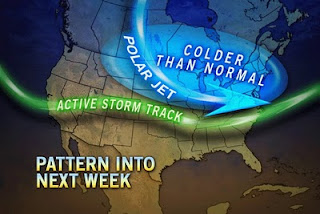
- A recent pattern change has allowed for several coastal low pressures to develop and take a run up the east coast.
-Storm 1 is in the gulf of mexico as we speak, bringing severe weather and drenching rains to the southeast. This storm will redevelop (as per usual) off the south carolina coast but will move much too far south to affect us. We are being protected by a blocking high pressure system to our east.
- A second storm will develop in nearly the exact same spot as storm 1 but this time will be allowed to ride up the coast as our high pressure moves further off shore. As it redevelops over water, it will pick up strength and moisture and intensify ever more as it collides with a pretty cold late March air mass that has been stubbornly sitting over us for a week. This battle ground of cold and warm air is very key.
- Our second storm will be strong with high winds and plenty of moisture. These early spring storms always have a lot of moisture. Remember our 14 inch rainfall in the last two weeks of March last year? Thursday night into Friday is the timeline.
What we don't know
- Track. I know you hear how important a storms track is all winter long but it is even that much more important in early spring storms. The exact track of the low pressure will determine who gets 15 inches of wet snow and who gets 1.5 inches of rain.
- That being said, the computer models used to forecast these storms are having a tough time with the placement of the storm track. This storm will be strong enough to pull in cold air for snowfall development. As you have heard before, the further the storm tracks to the east, the more that cold air will be wrapped into the region allowing for a widespread snowfall. Current models show the storm tracking over cape cod, bringing heavy snow west of 128 but drenching rain east of there.
- Coastal front set up. With such temperature differences in place, wind direction plays an important factor. You hear about coastal fronts when we talk about sea breezes keeping temperatures down in the summer. The same thing happens year round except this time, the wind off the water will keep coastal areas warmer.
- Amounts. No way of knowing. A recent snowfall projection map put out by the NWS in Taunton shows central and western Mass getting over a foot of snow while Boston gets all rain and then a late inch of snow as the storm passes. I would expect this to change several times before tomorrow night. There is just no solid way of predicting where the 32 degree line will be.
So that is it in a nutshell right now. I know there probably wasn't much information in here that you didn't already know but its a wait and see approach with this storm. We almost have to literally wait for the storm to be on our doorstep before any honest snowfall/rainfall totals can be forecast. I will keep you updated!
Wednesday, March 30, 2011
Monday, March 28, 2011
Friday Could Be the 2011 Winters Grand Finale
April 1 1997 is infamous for the April Fools storm that brought 25 inches of snow to Boston and over 30 inches to parts of upstate New York. Heavy snow too.
I very much doubt that happens this year, but the chances just got better of a very strong storm starting on Friday and lasting into Saturday.
Too much time before now and then to give specifics but heavy wet snow and sleet will be in play. And my least favorite, cold rain. Yuck!
Something to keep an eye on.
Also, something that is very strange for this time of year. I guess the air really is dry right now. That explains my obsessive need for water over the past few days.
Wednesday, March 23, 2011
Is It Really March?
Ok, so I am just about completely recovered from my trip to Amsterdam and Ireland. It was quite the time with many stories, most of which are not fit for publication! We will just leave it at that with one quick footnote, the weather for my 6 days in Ireland was perfect! No rain and sunshine the majority of the time with temps in the low 50's. Absolutely perfect.
Now back to reality. Snow? Yes. It is coming and yes it is pretty normal to get snow in early spring. This winter has been up and down with its snowiness. When it snows, it comes in bunches. When it doesn't, we get nothing for weeks. Well the snow is back. But don't expect anything like we saw in January.
With that being said, it is already snowing out as I speak. Not much to speak of with this system. Expect 1-2 inches on grass and cars overnight but I doubt it sticks to the roads. More like 3-5 inches as you head further south.
 The problem is the cold air doesn't want to go away. It will continue to be below normal temperature wise over the next 7-10 days. The cold air will keep getting reinforced by our old winter friend, a strong blocking high pressure system sitting over Greenland. That high won't move for the next week. Meaning cold but fairly quiet weather for us. While much of the rest of the country will be experiencing some pretty wild weather. So I suppose it could be worse.
For those aching for spring to come, patience. It will be here soon. With every passing day, we continue to get more sunshine from an increasingly stronger sun. Warm weather is realistically 3-4 weeks away.
Monday, March 21, 2011

Wednesday, March 9, 2011
Greg Goes Abroad!
The day has arrived. Europe will be getting their first (and possibly last) taste of Greg Porter. I think they are ready.
More to the point, will the weather be ready for me? You Boston people deal with more rain on Thursday/Friday and possibly some snow on Sunday. Not me! So without further delay, here is the expected weather for my destinations over the next week. Yes, this is quite possibly the most self centered post I have ever done but you know what? Who cares! Its my damn blog and I will do as I wish!
Amsterdam- Windy!! By the time I get there on Thursday morning, winds will be gusting out of the west at 30-40mph. That should make for a fun landing. Other than that, it looks to be cloudy with temps in the mid 40's. Sounds pretty familiar.
Dublin- My weekend in Dublin looks ( and this should be a big surprise) rainy! Saturday looks wet in the morning and cloudy in the afternoon. At least on Sunday it looks like we will get some sun! Both days will be in the mid 40's. So I guess I am technically going to a "warm" location for my spring break.
Assorted other Ireland cities - As we embark on our countryside tour of Cork, Dingle and Galway, the weather looks fantastic! Which is a good thing because I and my traveling partners will need all the help we can get trying to drive on the other side of the road. That should be interesting.
First up is Cork on Sunday into Monday and it looks nice. Partly cloudy with temps approaching 50! Or as they like to say 9 degrees Celsius. On a side note, my battle with the metric system should be interesting. Despite my love for all things weather related, I am a Fahrenheit guy. I may need to go the Brendan Connell route and write down the conversions in a notebook.
Dingle is next. Yes it is a funny name. But this is where the weather starts to look fantastic. High pressure settles overhead and we are looking at bright sunshine with temps easily into the 50's. Now that is what I am talking about!
From there we head to Galway and will be staying at a beautiful house in Athole. Once again, things are looking great weather wise. Which is a big deal for Galway. Being a city right on the coast and wide open to the Northern Atlantic usually means lots of rain and wind. But not next week! Both days are looking sunny and warm with temps in the 50's. I would imagine that it will be a bit colder overnight in Athole since it is further inland but since this town is pretty much off the grid, I can't confirm it.
And of course St.Patty's day in Dublin looks beautiful once again. Sunny,mild and drunk. That is probably a good forecast for all of next week really.
Anyways, I need to go finish packing since I have been writing this instead. I may try to update this once or twice during my trip but I certainly make no promises. Have a great St. Patrick's day all!
Sunday, March 6, 2011
Nice Weekend Turns to Heavy Rain
Not too shabby this weekend! 58 degrees today and 54 degrees yesterday. Despite the cloudiness, the warm temps gave us a nice taste of spring and what is to come.
For the immediate future, heavy rain is on the way. A frontal system has been sitting to our west all weekend, slowly moving more north than east. Heavy precipitation in the form of both rain and snow has been falling just a 150 miles to our west but you would have never guessed it with our weekend weather. A series of low pressure systems have been developing along the front and our bubble of protection is about to end.
Light rain is already moving into the area as I write this and as we get later, the rain will get quite heavy. So heavy that the NWS has issued a Flood Watchfor our area. A good 1-3 inches will fall in a matter of 12 hours. Quite a lot of rain. Winds will be an issue too as the temperatures behind the front are quite cold compared to our 50 degree readings of the past few days.
Tomorrow will be soggy and yuck, but Tuesday and Wednesday will be nice days before more storminess returns late week.
Coming tomorrow, I will feature some Ireland weather in anticipation of my first venture to Europe!!
Thursday, March 3, 2011
Long Range Forecast from Accuweather
Henry Margusity of Accuweather had some interesting things to say in his long range forecast for the beginning of spring.
"The weather pattern will remain stormy for another couple of more weeks. I was looking at the SOI Values, and they remain above 20, which means the La Nina is still roaring away. In addition, the NAO is heading to neutral, and the PNA is going to neutral, which tells me that a zonal flow with a buckling of the jet in the Midwest and East will persist. The implications are that storms will zip through the Western part of the country and strengthen as they get out into the Plains and Midwest. Severe weather, late-season snows, and heavy rains will occur with these storms, so again, I say watch every storm for some sort of extreme event."
Looks like March won't get any quieter. Although I am sure most of our storms will be rain. But don't rule out the possibility of one last snow storm!
Wednesday, March 2, 2011
Onto March! But First, a Taste of January

So its March 2nd! Welcome to the start of meteorological spring, with actual spring less than 3 weeks away.
After a record breaking January, the month of February seemed fairly tame. We hit 60 degrees twice. Boston never fell below 13 degrees. We "only" had 18.5 inches of snow. In fact, the majority of our precipitation fell in the form of rain. Despite our break from persistent storms, February did end up being above normal in terms of total precipitation. Even our slow months have been active!
But now it is March. Our sun is getting mighty strong. Any wind from the right direction combined with plenty of sunshine will push high temperatures well into the 50's (as we will see this weekend) As I said in an earlier post, we are on the front lines of the battle between winter and spring. We have seen a roller coaster ride of temperatures that looks to continue through this week and into the next. With every passing front, our temperatures seem to change dramatically. And there will be no better example of that than what we see overnight tonight.
As we speak, our winds have shifted from the mild southwest to the frigid northwest. With clear skies overhead and a strong pool of cold air moving into our region, temps will really bottom out. Suburban areas and higher elevations will be close to 0 while even Boston will get down to about 11 or 12 degrees. The other element will be the wind. Such a change in air mass usually always brings strong winds and tonight is no different. This is really impressive cold air considering how late we are into the season. I almost guarantee that this will be the last time that Boston sees temperatures this cold until next winter. So there is some good news!
Unfortunately, our strong March sun does no good tomorrow and Friday as both days will be pretty cold, especially tomorrow. Highs in the low 20's will be about 20 degrees below normal highs this time of year. Friday is better but again, still cold.
Don't be fooled by the warmer temperatures expected this weekend. Along with those 50 degree readings will be plenty of cloudiness and rain showers, the heaviest of which will likely be on Saturday.
From there, we turn our eyes to another coastal storm on Monday bringing a mixed bag to the region. Either way you cut it, Monday looks yuck. Long term forecast does show a tame, mild week after that though, which means my flight to Ireland should be nice and smooth!
Subscribe to:
Posts (Atom)