Thursday, September 22, 2011

Somebody pressed the pause button for the upper atmosphere. Over the next 5 days, an upper level low is going to get lost from the regular flow of the jet stream. And no one is in a hurry to look for him. Check this out


This is an upper air model for 8pm tomorrow night. Basically, this measures the vorticity or spin in the upper part of our atmosphere. Notice the big dip and vorticity max (denoted in yellow) over the Great Lakes.


This is the same parameter only 24 hours later at 8pm on Saturday night. Nothing has moved! That big white circle over the Atlantic is a strong high pressure system blocking any forward movement of the storm. Meanwhile, look up into Canada. Those closely packed together line represent the jet stream, which is WAY too far North for late September. And there is our storm, still lost and cut off from the party.

And finally, here is Sunday at 8pm. The storm has actually retrograded back to the west! This actually helps us dry out a little bit since this move backwards takes us out of the moist Gulf flow that will cause showers on Friday and Saturday. In this image, the storm has actually become even more isolated or lost. Someone needs to pick this bastard up and take him out to sea.


Bottom line, this is a very strong blocking pattern. When things get this backed up, it takes a big change to get things moving again. That won't happen until at least Tuesday. So expect clouds, showers and humidity from now until then. It won't rain all of the time, but it also won't be dry all of the time. Sunday does look like the driest day but I wouldn't expect much in the way of sunshine. Yuck!

Tuesday, September 13, 2011

Forecast Sneak Peek

Since my Umass Lowell forecasting debut was delayed one day by a certain NECN on air personality and Umass Alumni, I will give you dedicated followers (all 10 of you including mom!) a sneak peak at whats to come. This is a special treat and you should all feel lucky to be able to see this before it goes live.

By the way, as any good weatherman will tell you, I reserve the right to change this come tomorrow morning.
  
Wednesday

Mostly sunny and warm! This will be our last summer like day with temperatures running anywhere from the 78-84 for a high. There is the possibility of a brief rain shower that pops up in the late afternoon ahead of an approaching cold front.
  
Wednesday Night

Mostly cloudy overnight. Any lingering showers near the coast should end. Low temps about 56-60. This will be our last "warm" night for awhile.

 Thursday
Transition day. Kind of like moving day for the weather. But your new neighbors are going to be rain and clouds. Strong cold front approaches from the west. The morning should be dry and cloudy but heavy showers move in by the afternoon. Not as warm. 68-72

Thursday Night

 Steady rain early in the evening but as the front passes through, expect the rain to stop overnight. And once this front moves through, many people will be in for a temperature shock. Cloudiness should only keep lows in the upper 40's near Boston, lower 40's outside of the city. But that will  feel mighty cold compared to the upper 50's we had on Wednesday night.

Friday

Perfect day! High pressure rules the day in the wake of the cold front. Ample sunshine and temps in the low 60's. These are the types of mid September days that remind you that early fall weather is actually pretty damn nice. Friday night will offer you a taste of what will be coming eventually. Low temps overnight drop into the 30's everywhere!! Haven't had a 30 degree reading in Boston probably since last April.

Saturday and Sunday

 Both days look really nice. High pressure continues to sit overhead and provide sunshine and temps in the 60's.


Monday, September 5, 2011

Heavy Rain Tomorrow, Katia Makes a Close Pass Late Week

Let's start with Katia, since I am sure she is on the mind of most people right now. It is the #1 question that has been asked of me over the past few days. Everyone has hurricane fever! Or, the more likely scenario is that people just want to make small talk about the weather and hurricanes are the hot thing right now. I am no good at small talk.

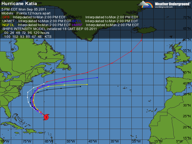
As I have been mentioning on and off via my Twitter feed (which you can find directly to the right), the forecast models have been a bit schizophrenic with Katia's projected path for a wide variety of reasons. The foremost reason having to do with Lee's progress. Now that Lee has made landfall officially, the model trends are starting to verify on a one particular path. But, there is still some room for error. Take a look at the image below from 4 of the more reliable models.

These 4 panels show the different projected position of Katia on Friday at 3am. Notice the disparity. All of the models have Katia running into a trough of low pressure over the east coast and getting pushed out to sea. The positioning of this low pressure trough has been a subject of great debate for the forecast models up to this point. A very slow moving cold front combined with tropical storm Lee moving northeast from the Gulf has created a bit a of a log jam in our atmosphere.

Nevertheless, the NAM model (upper right) is the only model that brings the storm close to New England. It also has Katia being a very strong hurricane at the time of her passage. Both of these scenarios seem unlikely. Katia will pass well west of Bermuda by Tuesday, probably as a category 3 storm, and she will appear to be heading for the Outer Banks of North Carolina.


As you can see, that is as close as she gets to land. By Wednesday, Katia will be picked up by the prevailing west winds of the jet stream and get pushed way out to sea. Our only side effects will be increased surf and rip tides all week as Katia stirs up the ocean. A near hit but we come out unscathed with this storm. Of course, there is another developing tropical system just exiting the coast of Africa as we speak. It is the peak of hurricane season for sure. 

In the near future, we can all expect to get very wet over the next few days. Now tropical depression Lee will continue to move northeast over the Tennessee Valley and become extra tropical. He will lose his name but Lee will still have plenty of rain.

By late tonight into tomorrow morning, we should be deep in the rain associated with that slow moving cold front. What's left of Lee will get picked up by this cold front and give us a second good downpour late Tuesday night into Wednesday. All of this rain and instability will be slow to move out of here as well. Expect tomorrow to be pretty much a washout and Wednesday and Thursday to have intermittent showers with some heavy downpours mixed in.

All in all, a pretty crappy week. Enjoy it!!