Thursday, December 1, 2011

Wild Winds In Southern California

Gusts as high as 70mph in Los Angeles today! The rest of the southwest is also very windy. The culprit? A VERY strong high pressure sitting off the coast of Seattle

A 1046 millibar high is extremely strong and usually reserved for the Arctic Circle or Northern Canada. Such a strong high is creating a very large pressure gradient over the western half of the country. Strong pressure differences causes air to flow faster from the lower pressure to the higher pressure which in turn creates wind and in this case STRONG wind. This graphic highlights the pressure differences and corresponding wind strength.


Luckily, the southern California and the southwest have been abnormally wet over the past few weeks or else we would be talking about a lot of brush fires and lots of damage.

Monday, November 28, 2011

High School Reunions and Still No Winter

First off, I would like to say again how awesome it was to see everyone at the BLS 10 year reunion this past Saturday night. I had a great time and it just reconfirms to me that despite Latin being a hardass school with questionable motivational tactics, the people I met there remain the best part about the school. I woudn't trade those relationships for anything.


Ok, now onto the weather! Or really, the lack of weather. November continues to remain extremely warm. We have had 12 days of 60 degree weather, making this the 2nd warmest November on record with temps running an average 5.4 degrees above normal. Interstingly enough, we likely won't top the warmest November on record, 1975, which had temps running over 7 degrees warmer than average!


One thing that is noteable about the top 5 warmest Novembers, including our current month, is the lack of snowfall for the remainder of the winter. I am starting to believe this winter will be no different.


So why the lack of cold air? To make a food reference (since Thanksgiving did just pass) we are missing some key ingredients.


1.) The Greenland Block -


This is a crucial piece to maintaining cold air over the east coast. As you can see from the image to the right, a typical high pressure over Greenland sets up a blocking pattern in the Northern Atlantic, allowing cold air that has been building up over the Hudson Bay to move south and stay locked in for several days. This whole process is part of a bigger process called the North Atlantic Oscillation but I won't get into that as it is confusing and boring to read about. Just know this, no Greenland High means that cold air may come and go, but it won't stay for more than a day or two.


2. Irregular Jet Stream- You should know that the jet stream is what drives our weather and air masses. If you have been watching the news over the past month, you probably have heard about other abnormal weather occurances happening all over the country. This is due to an irregular pattern for the fall. This image is a good visualization of what is refered to as a negative PNA which has been our reality for many weeks. The Northwest and even California are contiually being pounded by storms while we here in the Northeast have been tapping into the warm Gulf temperatures, keeping us unseasonably warm and dry.

Of course, there are other factors that play into this. A weaker than predicted La Nina is the likely culprit of this abnormal set. What this has led to is a very progressive and warm atmosphere for us. Storms and air masses have been moving very quickly, followed by strong winds the day after. But in between, we continually see west to south west flows with 50-60 degree readings and sunny skies.

Eventually, normal climate impacts will take over. The core of warm air we have been tapping into will get weaker and the cold air building in Canada will get stronger. Our days get shorter and there will be less oppurtunity to warm up during the daytime. I doubt we will be seeing 60 degree readings in January, but one thing that does seem to be sticking around is the lack of any blocking pattern.


The abnormal (netative PNA) jet stream set up is showing signs of breaking down over the next few weeks, which should allow colder air to "break away" and move into our area. But with no blocking in place, our atmosphere remains very progessive. Typically this will mean more seasonable weather but no big storms.

Regardless of the reasons, I know everyone is enjoying this warm weather. Even I am liking it, despite my love of big snow storms but I would be lying if I said that I didn't want a nice 2 foot snow storm for Christmas!

Monday, November 14, 2011

Where has the cold air gone?

You may have noticed that something is missing. It's not obvious at first. It even took me until yesterday to figure it out. It was just after 8:30am and I was outside, with no coat on and felt very comfortable. 8:30 in the morning on November 13th should not be short sleeve weather.

Take a look around and you will see the wardrobe malfunctions too. They are very typical of seasonal transition times. The jerk who wears shorts on the first 70 degree day in April only to be freezing once the sun goes down and the temperature drops back into the 30's. Or what about those borderline warm days near the end of a (typical) fall? I see a lot of people, mainly bro's, who head out in jeans, short sleeves and no coat, only to find out that even though the temperature says 58, the strong winds actually make it feel like it is in the 40's.

But these days, its just the opposite. Yesterday morning, I saw many people wearing heavy coats and even gloves! Its like we are all kids in a classroom hoping the teacher forgets to assign homework. We know it should be cold. We expect it to be cold. But everyone is hoping that perhaps old man winter forgot to put New England on his to do list this year.

As I write this, Boston's temperature is 56 degrees at 9:00 pm on November 14th. Our normal HIGH temperature for this date is 45. And it has been this way for pretty much all of Autumn. Average temperatures have been running a good 4-6 degrees above average up and down the East Coast for weeks. This was the 8th warmest October on record! And not only that, we have been relatively dry and storm free. Outside of our Halloween snowstorm, our area has had several long stretches of dry weather, including a 10 day stretch that ended last Thursday. Dry and Warm? In a New England fall? You might get one or the other but both together for this long of a period is unusual.

So, just where is all of our typical Fall temperatures? MIA. Well, really they are just stuck in the Arctic. There is plenty of it up there, believe me. It just so happens that the forces at be are currently keeping the cold air stuck in the Arctic and more importantly, stuck high in the atmosphere.

Nothing is going to change through Thanksgiving. We have hit 60 degrees 8 times already in November and at least 2 more are in store in the next 7 days.

But we all know. The other shoe will drop eventually. Pattern changes appear to be coming by the end of the month and once the door is open for that cold air, it won't fully close until April.

Friday, October 28, 2011

October Blizzard. No, This Is Not a Joke

For about 4 or 5 days now, the European model guidance (which they don't provide for free like our National Weather Service does with our models) has been continuously predicting a very strong coastal low to impact New England with heavy snow this weekend.

No one who pays attention to these models believed it. Every other model kept us dry and sunny. But the weekend kept getting closer and the Euro kept showing the same storm over and over again in a shockingly consistent manner. We all know the weather changes on a dime and predicting what will happen even 24 hours in the future can be near impossible at times. But the Euro has been so god damn consistent all week that its snow storm idea kept becoming more and more plausible.

Now here we are, about 24 hours away from what could be considered the zero hour and we come to find out that the Euro was right all along. Even as I type this it doesn't seem real but tomorrow night, we will be in the middle of an all out blizzard.

There is so much to talk about, I don't even know where to begin. Lets focus on some startling facts first.

Monthly snow total record for Boston in October - 1.2 inches
Amount of nights under 32 degrees in Boston this year - 1(last night was the first time we went below freezing)
Deviation in average high temperature in Boston this month - + 6 degrees 

I could go on like this but I think you get the point. The freaking leaves haven't even fallen off the trees yet! All of this adds up to what is a remarkably UNIQUE situation that we all need to start getting prepared for, regardless if we find it hard to believe or not.

I will post a more technical piece later on the "perfect" set up for this October blizzard, and I do mean perfect. Even more perfect than the infamous "Perfect Storm" in 1991. Perhaps George Clooney will be making a movie on this event one day.

Anyways, here are the details....

- Storm time line is from about 7pm tomorrow night till 7am Sunday morning.
- VERY strong wind gusts could peak close to and above tropical storm force at times
- Biggest issue and I do mean BIGGEST issue is power outages. It is going to get bad. Heavy wet snow combined with leaves on the trees and strong wind gusts is a terrible combination. I would advise people to get generators and batteries now.
- Snowfall totals are very hard to make a call on right now. There is not much of a precedent for this type of storm this early in the season. Where it stays all snow, in central/western Mass, southwest NH and interior CT, I can easily see 6-12 inches of heavy snow piling up. The coastal plain is impossible to predict. It is all about wind direction. Any east or northeast wind blowing off the 58 degree water (it is still October!) will warm Boston and any area 30 miles within the coast to the lower 40s. But once that wind direction changes to the North, and it will overnight, temps will drop everywhere and we will all turn to snow.
- Coastal flooding should be a concern. Tides are running very high right now and once this storm gets past Long Island, it looks like it is going to "bomb out" or get very very strong in a matter of hours. In fact, the predicted pressure level of the storm will put it on par with strong tropical storm or a weak hurricane in terms of intensity.

That is all I have for now. News of this will gradually leak out, especially once people get out of work. I know it seems like a joke ( I thought it was a joke for a whole week now) but take this storm seriously!


Thursday, September 22, 2011

Somebody pressed the pause button for the upper atmosphere. Over the next 5 days, an upper level low is going to get lost from the regular flow of the jet stream. And no one is in a hurry to look for him. Check this out


This is an upper air model for 8pm tomorrow night. Basically, this measures the vorticity or spin in the upper part of our atmosphere. Notice the big dip and vorticity max (denoted in yellow) over the Great Lakes.


This is the same parameter only 24 hours later at 8pm on Saturday night. Nothing has moved! That big white circle over the Atlantic is a strong high pressure system blocking any forward movement of the storm. Meanwhile, look up into Canada. Those closely packed together line represent the jet stream, which is WAY too far North for late September. And there is our storm, still lost and cut off from the party.

And finally, here is Sunday at 8pm. The storm has actually retrograded back to the west! This actually helps us dry out a little bit since this move backwards takes us out of the moist Gulf flow that will cause showers on Friday and Saturday. In this image, the storm has actually become even more isolated or lost. Someone needs to pick this bastard up and take him out to sea.


Bottom line, this is a very strong blocking pattern. When things get this backed up, it takes a big change to get things moving again. That won't happen until at least Tuesday. So expect clouds, showers and humidity from now until then. It won't rain all of the time, but it also won't be dry all of the time. Sunday does look like the driest day but I wouldn't expect much in the way of sunshine. Yuck!

Tuesday, September 13, 2011

Forecast Sneak Peek

Since my Umass Lowell forecasting debut was delayed one day by a certain NECN on air personality and Umass Alumni, I will give you dedicated followers (all 10 of you including mom!) a sneak peak at whats to come. This is a special treat and you should all feel lucky to be able to see this before it goes live.

By the way, as any good weatherman will tell you, I reserve the right to change this come tomorrow morning.
  
Wednesday

Mostly sunny and warm! This will be our last summer like day with temperatures running anywhere from the 78-84 for a high. There is the possibility of a brief rain shower that pops up in the late afternoon ahead of an approaching cold front.
  
Wednesday Night

Mostly cloudy overnight. Any lingering showers near the coast should end. Low temps about 56-60. This will be our last "warm" night for awhile.

 Thursday
Transition day. Kind of like moving day for the weather. But your new neighbors are going to be rain and clouds. Strong cold front approaches from the west. The morning should be dry and cloudy but heavy showers move in by the afternoon. Not as warm. 68-72

Thursday Night

 Steady rain early in the evening but as the front passes through, expect the rain to stop overnight. And once this front moves through, many people will be in for a temperature shock. Cloudiness should only keep lows in the upper 40's near Boston, lower 40's outside of the city. But that will  feel mighty cold compared to the upper 50's we had on Wednesday night.

Friday

Perfect day! High pressure rules the day in the wake of the cold front. Ample sunshine and temps in the low 60's. These are the types of mid September days that remind you that early fall weather is actually pretty damn nice. Friday night will offer you a taste of what will be coming eventually. Low temps overnight drop into the 30's everywhere!! Haven't had a 30 degree reading in Boston probably since last April.

Saturday and Sunday

 Both days look really nice. High pressure continues to sit overhead and provide sunshine and temps in the 60's.


Monday, September 5, 2011

Heavy Rain Tomorrow, Katia Makes a Close Pass Late Week

Let's start with Katia, since I am sure she is on the mind of most people right now. It is the #1 question that has been asked of me over the past few days. Everyone has hurricane fever! Or, the more likely scenario is that people just want to make small talk about the weather and hurricanes are the hot thing right now. I am no good at small talk.

As I have been mentioning on and off via my Twitter feed (which you can find directly to the right), the forecast models have been a bit schizophrenic with Katia's projected path for a wide variety of reasons. The foremost reason having to do with Lee's progress. Now that Lee has made landfall officially, the model trends are starting to verify on a one particular path. But, there is still some room for error. Take a look at the image below from 4 of the more reliable models.

These 4 panels show the different projected position of Katia on Friday at 3am. Notice the disparity. All of the models have Katia running into a trough of low pressure over the east coast and getting pushed out to sea. The positioning of this low pressure trough has been a subject of great debate for the forecast models up to this point. A very slow moving cold front combined with tropical storm Lee moving northeast from the Gulf has created a bit a of a log jam in our atmosphere.

Nevertheless, the NAM model (upper right) is the only model that brings the storm close to New England. It also has Katia being a very strong hurricane at the time of her passage. Both of these scenarios seem unlikely. Katia will pass well west of Bermuda by Tuesday, probably as a category 3 storm, and she will appear to be heading for the Outer Banks of North Carolina.


As you can see, that is as close as she gets to land. By Wednesday, Katia will be picked up by the prevailing west winds of the jet stream and get pushed way out to sea. Our only side effects will be increased surf and rip tides all week as Katia stirs up the ocean. A near hit but we come out unscathed with this storm. Of course, there is another developing tropical system just exiting the coast of Africa as we speak. It is the peak of hurricane season for sure. 

In the near future, we can all expect to get very wet over the next few days. Now tropical depression Lee will continue to move northeast over the Tennessee Valley and become extra tropical. He will lose his name but Lee will still have plenty of rain.

By late tonight into tomorrow morning, we should be deep in the rain associated with that slow moving cold front. What's left of Lee will get picked up by this cold front and give us a second good downpour late Tuesday night into Wednesday. All of this rain and instability will be slow to move out of here as well. Expect tomorrow to be pretty much a washout and Wednesday and Thursday to have intermittent showers with some heavy downpours mixed in.

All in all, a pretty crappy week. Enjoy it!!


Monday, August 29, 2011

Goodbye Irene

She has left us, officially entering Canada sometime late last night. But not before causing leaving her mark on pretty much the entire east coast of the country. Let's take a look at the final numbers.

Highest Rainfall Totals
Bunyan, N.C., 14.00 inches
Plum Point, Md., 12.96 inches
Ft. Eustis, Va., 12.52 inches
Ocean City, Md., 12.09 inches
Perry Hall, Md., 12.00 inches
Washington, N.C., 11.31 inches
Camp Springs, Md., 11.21 inches
New Bern, N.C., 11.13 inches
Suffolk, Va., 10.71 inches
Grifton, N.C., 10.53 inches

Highest Wind Gusts
Cedar Island, N.C., 115 mph
Fort Macon, N.C., 92 mph
Hatteras, N.C., 88 mph
Conimicut, R.I., 83 mph
Barrington, R.I., 82 mph
Buxton, N.C., 79 mph
Cape Lookout, N.C., 78 mph
Oregon Inlet, N.C., 78 mph
Cobb Island, Md., 73 mph
Chesapeake Beach, Md., 72 mph

Top Rainfall and Wind Gusts in Massachusetts
Conway, 9.92 inchesEast Milton, 81 mph
Ashfield, 9.10 inchesFairhaven, 72 mph
Savoy, 9.02 inchesNorwood, 66 mph

Top Rainfall and Wind Gusts in Rhode Island
Warren, 5.37 inchesConimicut, 83 mph
West Glocester, 4.02 inchesBarrington, 82 mph
Burrillville , 3.86 inchesWarwick, 64 mph

Top Rainfall and Wind Gusts in Connecticut
New Hartford,10.15 inchesGroton, 67 mph
Bulls Bridge, 10.02inchesThompson, 66 mph
Torrington, 9.07 inchesBridgeport, 63 mph

The rainfall numbers in Vermont were even more dramatic in a shorter time frame, with most locations picking up anywhere between 3 inches of rain to as much as 9 inches of rain in only a matter of a few hours!! That is why we saw those amazing images of flash flooding up there.

Facts are facts and Irene was not as strong as originally feared. The forecast track that began to take shape a good 48 hours before any landfall was actually the storm track that verified. She drove a little further inland over North Carolina and Virgina than was predicted. This inland position sapped her of a lot of energy and she likely lost all hurricane status by sometime Saturday afternoon. I assume that the National Weather Service will go back and look at the data, possibly reclassifying Irene as a tropical storm just after she made landfall.

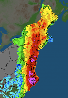
As is he case with extra tropical systems, most of her rainfall became situated on the western side of the storm. Her eastern side became almost devoid of moisture as she began to quickly weaken.

Despite her lack of hurricane force winds, you see the kind of damage that was caused in our state alone. Thousands of trees down, tens of thousands without power. Most of Massachusetts suffered some kind of wind related damage but the real story with Irene became her rainfall. She dumped tons of rain all the way up the coast, as you can see from the image posted above.

So was Irene a dud like my brother told me yesterday? Yes and No. Several days out, it was clear that Irene was going to have a big impact on the east coast and that ended up being true. Forecasting the intensity and track of hurricanes is quite hard but forecasters did a great job with this storm. We all saw first hand what even a moderate tropical storm can do damage wise. I keep hearing people say this was no worse than a nor easter in the winter but I would have to whole hardily disagree with that. These types of storms are much stronger and much bigger and also carry much more moisture with them. Be thankful that we avoided a direct hit, be thankful that the weathermen were on top of this from the beginning and nailed the forecast (people always forget when weathermen get things right) but also don't get the facts twisted. Tropical systems are dangerous, even when they only take a swipe at us.

So, where do we go from here? Well I imagine that many of you still don't have power and I hope that gets fixed soon. Just about all of us saw some trees fallen and thousands of branches and leaves everywhere. I saw firsthand the fury of the ocean when I went down to castle island yesterday afternoon. The waves were amazing, and I was not even on the open ocean.

Irene will go down as a nuisance for most people. But consider yourselves forewarned. The tropics are being VERY active right now and trends tend to emerge with the tracks of these storms. All of us should be prepared over the next few weeks for the possibility of another tropical system taking aim at us.
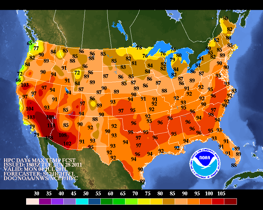
Friday, August 26, 2011

Irene will be just like Gloria(1985)

Some of you might remember Gloria. Some, like myself, might not. The only thing I remember from Hurricane Gloria is from what my mother told me (In my defense, I was only 2). My parents current house in West Roxbury lost power when a power line came down in the backyard and electrified the metal chain link fence. This story, along with my patched together memories of Hurricane Bob (1991) fueled my love of weather. In this, I have no doubt.

But regardless of my passion's origins, I bring up Gloria with good reason. Irene is doing her best to copy Gloria, only 25 years later.

Gloria was actually a tropical storm by the time it affected Boston, but this fact is always omitted whenever I have heard stories about her. It is with this fact that I bring to attention Irene's current weakening state.

It is likely that Irene makes landfall somewhere near New London, CT. Matt Noyes of NECN has been calling for this in excess of 60 hours now, despite the National Hurricane Center's projected Irene path to cross over NYC.

Wether or not Irene is a hurricane or a tropical storm at her time of impact is a non factor. She will be so big, and so spread out that she will have essentially taken her strongest winds(at the core) and averaged them out in a radius of 200 miles. Her overall category might be lowered, but our impacts remain the same. Irene will cause wind damage, storm surge and flash flooding, regardless of her classification.

I do caution people to take her seriously. Many friends and family members have asked me what to expect. I don't envision any doomsday senario that some media outlets might be portraying. But I also don't expect Irene to miss us completely like that which has happened in the last 20 years of the Atlantic Hurricane season. Yes, the last hurricane to actually hit us was Bob in 1991.

The point I am trying to make is this. Irene might not be a fiercely sounding storm by the time she hits come Sunday morning. But her force will be felt by us all. Tropical systems pack a strong punch. Boston will be subject to heavy (40-50mph) sustained winds. Yes, SUSTAINED. That means that at one particular time on Sunday, the wind will be blowing at a consistent speed of 40-50mph. Not gusting but consistent. That will cause some damage. Don't be surprised if you lose power.

Take caution! Listen to local weather forecasts for updates. Irene is coming on Sunday morning. She won't knock us out but she will deliver quite the blow. No pun intended of course.

Thursday, August 25, 2011

Change in Track is Likely

By now, we all know that Irene has shifted her projected track to the west, causing those in the mid atlantic and New York to speak of doomsday while we here in New England talk about how we dodged a bullet.

Both parties are wrong to prematurely speculate on possible outcomes. Yes, the track has shifted west due to the lack of any mid level steering as is noted below in the latest GFS outline of upper level winds as Irene approaches the coast.

The upper level disturbance lies to the north of the great lakes, in Canada. This puts it too far north to interact with Irene in a timely manner, keeping her close to the coast. Also, notice that the strong area of high pressure over the four corner states has set up further west than previously thought, preventing it from pushing Irene further to the east, north east.

The last 24 hours of various model runs have shown this, thus the official change in track. But lets take a closer look at those model runs.

The latest model runs show a split in thinking. Two models take Irene inland over the Chesapeake Bay area and track her center near NYC. This is where the current predicted path lies as well. But two other, just as reliable models, take Irene further east and almost directly over the south shore of Rhode Island and Massachusetts. So why the agreement with the more easterly track?

With weather models, its as much about trend as it is about anything. Recent trends have pulled Irene back to the west for over 24 hours now. And the models predicting this western path have been more accurate in predicting where Irene has gone so far. Therefor, trend and accuracy has officially shifted Irene to the west.

But these other two scenarios are just as statistically likely to happen, they are just not the popular choice. Matt Noyes, who maintains a great personal weather website has been consistantly calling for a landfall somewhere within 60 miles of New London, CT. I completely agree with his prediction.

Two major models calling for a Southern New England landfall are too hard to ignore, especially just over 80 hours away from storm impact. I say, forget recent trend and let's look at historical trend. A hurricane cutting up the Hudson River Valley is not the norm. The earth's rotation along with the higher latitude create those powerful westerly winds known as the westerlies. The further north a system gets, the more to the east, northeast it begins to turn.

Irene will turn to the northeast at some point. Right now, it looks like that happens after she makes landfall near New Jersey. But in 24 hours, that landfall location could have easily shifted back to the east by 100 miles, causing much more damage to southern New England than currently thought.

That said, take preliminary precautions now. Yes, we all make jokes about the people buying all of the milk and bread from grocery stores. But in all honesty, hurricanes are a different beast than our typical Nor' Easters from which we gain so much New Englander pride. They are stronger and much wetter.

At the very least, make preparations to be without power for a few hours. Power lines could easily come down, even with the current Irene track forecast. And the flooding. A large amount of water will be falling from Irene, particularly to the west of her center. 2-6 inches of rain in 12 hours is a lot. Especially for soil that has been very dry for most of the summer. ( Recall last week's torrential rain and resulting urban flooding) Dry soil does not take well to torrential rains.

Be prepared to stay indoors from Sunday afternoon into Sunday night.

Westward Shift in Irene Track


Beginning late last night and continuing today, the models have trended back to the west with Irene's path. This slight shift is due to the presumption that Irene will not get "picked up" by a short wave moving out of Canada which would have pushed her more northeast and towards Boston. She will now likely hug the east coast very closely and bring historic rains and flooding to many of the major cities.


This latest GFS rainfall estimate shows just how much water is going to be dumped along the east coast. Upwards of 8-14 inches in parts of Delaware and New Jersey! New York City should also be concerned with flash flooding and tunnel flooding.

As for Southern New England, while this change in the track has us avoiding a direct hit, we are by no means in the clear. On Saturday, Irene will begin to interact with the cold front that will fire off some severe thunderstorms on our region, which by then will have moved off shore. This interaction will allow her to grow in size, making Irene a very BIG storm in terms of square mileage.

We will actually see some heavy rain in our area starting late Saturday night into Sunday morning. Technically, this rainfall is not part of Irene but you mind as well consider it the beginning of the storms effects.

Since we will be on the eastern side of the storm, expect wind to be the main factor for most of Southern New England. At this point, gusts of 50-95mph seem quite likely to occur on Sunday, with sustained winds probably somewhere from 35-45 mph. Total rainfall from Irene should total around 3-6 inches but I would suspect much of that falls late Saturday night into Sunday morning. Once the eye gets close to eastern Long Island, the vast majority of the rainfall will lie on the western side of the storm.

Storm surge will be a major factor for immediate coastal areas. Tons of water will be pushing northeastward ahead of Irene, likely causing some moderate to major flooding in south facing coastal areas.

So to recap...

- Westward shift in track means less rain for us but raises the possibility of stronger wind gusts and storm surge flooding.
- Storm speed is slowing a bit with lack of mid level driving feature. Landfall expected near NYC sometime Sunday night.
- Heavy rain ahead of the storm begins Saturday night
- Irene will likely be a category 1 or tropical storm by the time she makes landfall, since this new path does not keep her over the water.

This new track is obviously good news for us in Boston but by no means is this guaranteed to occur. You all know that hurricanes are extremely hard to forecast and since this event is still over 72 hours away, there is plenty of time for the track to change. These storms typically turn to the northeast so a path that follows the east coast closely is unusual. Nevertheless, this is how it seems to be playing out right now.

Everyone in the region should be monitoring forecast changes. Usual updates to track changes from the National Hurricane center happen later this evening at 5, 8 and 11.


Wednesday, August 24, 2011

A Trip Down Hurricane Memory Lane

With Irene looking more likely to have a significant impact on Southern New England this weekend, I thought it to be beneficial to take a look back at some similar storms and storm tracks from our recent hurricane history.

Let's jump in the way back machine to 1999. Where were you on September 16th of that year? If you were in Boston, chances are you were hunkering down for Hurricane Floyd.

Floyd was born on September 7th 1999 and took a very similar path to Irene trough the Bahamas. In fact, Floyd's eventual path ended up looking very similar to what forecasts are calling for Irene to do.


Floyd actually became a category 5 hurricane while over the Bahamas and as he approached the eastern seaboard, hurricane watches and warnings were put up at some point from Florida City, FL to Plymouth, MA. President Clinton even went so far as to declare state of emergencies in Florida and Georgia before the storm even made landfall. At the time, Florida was just 7 years removed from the devastating hurricane Andrew. Andrew had also developed in a very similar manor and area as Floyd.

In a mere 24 hours, Floyd went from a category 1 hurricane with maximum sustained winds a 95 knots to a high end category 4 hurricane with maximum sustained winds at 135 knots. In this time period, the central pressure of Floyd dropped 40mb! That is some rapid intensification. Later, in their follow up report of Floyd, the National Hurricane Center attributed this rapid intensification to " the presence of enhanced upper oceanic heat content along its track."

Take a look at the current sea surface temperatures for the Atlantic.

Notice the pool of super heated water that Irene is about to travel over, just east of Florida. This is the same type of situation that allowed Floyd to rapidly intensify. Expect Irene to follow a similar intensification pattern, although she will likely fall short of a category 5.

The next glaring piece of similarities between Floyd and Irene has to do with the projected and eventual path.

As is the case with all tropical systems in the far Atlantic, each storm travels almost due west, riding along the equator and using the prevailing easterly flow to direct its travel. Once these storms enter the Caribbean, they begin to interact with the westerilies or the west trade winds. This ultimately begins to curve the storms into a more north westerly path and then ultimately a north to north easterly path. It is called the storm re curvature period and it has a direct impact on where a hurricane will make landfall if it does at all.

The 500 mb level of the atmosphere is the steering wheel of our atmosphere. It is here where wind direction, troughs and ridges (heights) influence how intense a hurricane will get and where its path will be. The National Hurricane Center had this description of the 500 mb profile that lay in front of Hurricane Floyd,

"As a mid- to upper-tropospheric trough over the eastern United States eroded the subtropical ridge over the extreme western Atlantic, Floyd continued to turn gradually to the right. The center of the hurricane paralleled the central Florida coast, passing about 95 n mi east of Cape Canaveral around 0900 UTC 15 September. By the afternoon of the 15th, Floyd was abeam of the Florida/Georgia border and headed northward toward the Carolinas."


I realize that this explanation is a bit technical. What this statement essentially says is that sinking, drier air to the north and east of Floyd began to dig in behind and to the right of the storm. Combine this with the interaction with the westerlies and you have a hurricane that starts to turn right, just like Floyd did.

Take a look at this predicted 500 mb steering patterns for Irene

Again, I know this map is a bit technical. Credit for the map and description goes to Phils Tropical Weather Blog. What this (a bit outdated) model shows is quite similar to the steering patterns for Floyd. A strong ridge of high pressure over the atlantic along with strong high pressure over the mid west. In between these two ridges, little short wave troughs ( upper level storms) will continue to move south eastward from Canada. One of these shortwaves will interact with Irene, much like Floyd began to interact with a quickly moving cold front back in 1999. Think of that narrow path between the two high pressure systems as the "cone of uncertainty that you often see with projected hurricane paths.

So, since we can see that Floyd has two very strong similarities to Irene, what ultimately became of Floyd and his impact with New England? This is where I begin to preach caution with anyone getting ahead of themselves with a doomsday prediction. Floyd was ultimately a bust as far as New England was concerned.

He eventually made landfall in extreme eastern North Carolina on September 16th and brought historic and deadly flooding to that whole state. From there, despite hurricane warnings begin posted all of the way to Plymouth, Floyd began to weaken rapidly, as most hurricanes do when they interact with land and colder water.

Floyd tracked just to the east of NYC and to the west of Boston, ultimately losing his strong winds but maintaining his heavy tropical rainfall. Looking at the final rainfall totals below, you can see the outrageous amount of rain that fell to the west of the storm. With hurricanes, the heaviest rainfall is always of the western side of the eyewall while the strongest winds lie on the eastern side.

Boston would have been in line to see the strongest winds from Floyd, but he was just barley a tropical storm by the time he got to us on the 17th. We saw our fair share of rain (nothing like North Carolina) but the threat of a catastrophic land falling hurricane for Boston just didn't pan out.

Will this same result happen with Irene? It is impossible to say at this point. Emotions will likely be running high in our region with the threat of a major hurricane. Emergency preparations should certainly be taken and all citizens should be watching for updates on Irene. Just remember that hurricane tracks are EXTREMELY hard to forecast. Probably one of the most difficult things a meteorologist has to do.

Right now, Irene looks like she will stay over water and make landfall as a major hurricane in Southern New England. Back in 1999, Floyd had the exact same expectations and we saw what happened there. Sometimes in these types of scenarios, historical patterns should take precedent over emotionality charged assumptions.

I will have more updates on Irene later tonight.

Monday, August 22, 2011

Irene Deserves Our Attention

The first major hurricane of the 2011 Atlantic season is in the process of forming and she poses a very good chance of making landfall somewhere along the Atlantic east coast. In the past 24 hours, all model guidance has shifted the storm further east, keeping Irene over warm Caribbean water and allowing for further strengthening. Let's look at some details.


Here she is, in all of her glory. Irene is currently a moderate category 1 hurricane with top winds at about 100mph. You can see from this latest water vapor image that Irene is no longer suffering from the shearing effect on her south west side that had been happening earlier today. Combine this with a move to warm ocean waters and you will see rapid strengthening in the next 24 to 48 hours.

The latest computer ensembles (clusters of weather models running different variables) continue to pull Irene further and further to the east. As of 4pm today, it looked like she was going to make a direct hit on South Carolina. Now, it appears as if she will just brush the Outer Banks and make a move up the east coast.

Now, before we begin to get into panic mode, there are many factors that need to play out in order to have this path verify. Follow me, if you will, into weather geek land.

It is a bit fuzzy, I know. This map is an ensemble map of the 500mb level heights, temperature and vorticity. Basically, this map measures spin in the upper atmosphere, the part of the atmosphere that dictates where storms track on the surface. This particular map shows that what we call a upper level short wave will be moving from the Great Lakes to New England sometime on Friday. Depending on how quickly this short wave or spin in the upper atmosphere moves will make a big difference on where Irene goes. If it moves quickly enough, Irene will get sucked up to the North and she will ride up the east coast, picking up tremendous speed and staying over the ocean.

Right now, this looks like the most verifiable situation, with Irene actually cutting inland over New England and bringing torrential rain and some high gusty winds late Saturday night into Sunday.

Of course, this all deserves our attention. Our ocean waters are at the warmest point of the year right now and should Irene stay over the water long enough, we could start to see some hurricane watches be put up later this week. Stay tuned!!

Friday, July 22, 2011

103 Degrees, Second Hotest Temp Recorded in Boston

Damn. It was hot today.

- From 3-5 this afternoon, the city of Boston sat at 103 degrees, the second highest temperature ever recorded in the city with the highest value being only 1 degree higher (104 July 4th 1911)

- We tied the record high for the day from 1926. So don't go all global warming on me. Yes, this is unusually hot for Boston, but it does happen from time to time and it is summer time. The rest of the country has been in this extreme heat for most of the summer. We just got our first taste today.

- Tonight will not be a comfortable night for sleeping. Dew points are getting lower, but the air temperature is just not dropping. In fact, we may set another record for the highest minimum temperature recorded.

- Despite drier air working its way into our area on Saturday, we will still manage to get very hot, with a high temperature of anywhere from 96-99 degrees. Unlikely we reach 100 again. It won't feel as bad as today but hot is hot and we have one more day of it.

- Sunday will feel like heaven compared to the last few days. 80 degrees and low humidity. Just tough it out until then and make friends with someone who has a pool

Monday, July 18, 2011

Heat Wave Finally Gets Us

This week will be a hot one. Thursday and Friday will be the worst of it. We might even hit 100 on Friday! Take a look at the predicted high temps for Friday.


The whole east coast will be baking, with dew points running very high too. It will be a very uncomfortable day. The record for for July 21st is 102 and we will be close to that reading.

Saturday, July 16, 2011

Beautiful Weekend, Severe Storms on Monday

It can't get much better than the stretch of weather we have had for the past week. Yesterday was only 79 degrees in Boston with low humidity and plenty of sunshine. That feels more like September than July!

Outside of some late afternoon thunderstorms on Wednesday, we here in New England have been living the good life while the rest of the country bakes. Even precipitation wise, we have had it good. We are a good 2 inches under where we normally are for the month of July. Just perfect conditions.

Just look at the forecasted high temperatures for tomorrow. Middle America is really feeling the heat. Those poor people have had triple digit temps for a good week now and there is no end in sight.

Why has it been this way? A very strong and persistent ridge, a dip in the jet stream, has been holding court over the west coast, keeping them cool and cloudy while at the same time opening up the flood gates for the rest of the country. Look at tomorrows jet stream map and you might be able to see what I mean.

See it? A huge ridge of high pressure is sitting right over Nebraska and it has pretty much been there for the whole month of July. Meanwhile, we here in the northeast have avoided most of the core heat. Starting tomorrow though, we will see our temps and dew points steadily rising, making both Sunday and Monday much more uncomfortable than the past few days have been.

Which brings me to my last point. Monday afternoon looks to have some strong thunderstorm potential. In fact, the set up is similar to the one we had back on June 1st, the same day of the tornado "outbreak" in western MA. I am not saying that we will have another tornado situation. That seems pretty unlikely given how rare it is in the first place and how far into the summer season we are now. But the threat of severe thunderstorms will be real.

I will try to have more on this later but I make no promises since I will be at Kevin Mann's wedding tomorrow!

Tuesday, June 28, 2011

July 4th Weekend

Well, the rest of the east coast will be experiencing a nice 2 day heat wave starting on Saturday. What about us? Right now, it looks like we get a nice warm weekend with mixed clouds and sun but dry at the very least. Check out the 3 day temperature forecasts countrywide for the holiday weekend.

Saturday


Sunday


Independence Day

Sunday, June 26, 2011

July 4th Weekend Heat Wave

Not too early to look to next holiday weekend! Early indications show some 90 degree + heat for July 2nd and 3rd for pretty much the whole east coast.

New England is included in that heat burst right now but another pesky cut off low might hover near Nova Scotia and give us a cool and cloudy wind off the water. Sound familiar? Seems like we have had a lot of that lately. Keep your fingers crossed for the heat!

July 2nd


July 3rd

Monday, May 23, 2011

Hello Spring, Its Me. Are You Out There?

So my breaking point was at the red sox game this past Saturday night. I knew it was going to be a tough week. Lots of clouds, intermittent rain and a pesky on shore flow that kept our temperatures well below where they should be. But I have a personal rule, I will not attend a red sox game before the 2nd week of May as I do not care to be sitting in an old wooden chair all bundled up drinking my overpriced and under served beer.

So with two games last week, I assumed all off season that I would be in the clear. Not so my friends. Wednesday? I felt like I was watching a haunted baseball game with the consistent cloud of mist that hovered over Fenway all night. It was so shitty out that I wasn't even able to find a last minute person to accompany me to the game. First time that has ever happened. By the time the downpour came in the 7th inning, I was way too drunk and way to close to the field to give up on the game. I stuck it out till the end and saw a great game. Got soaked and felt like a loser going alone but it all worked out in the end.

Saturday, things could not have looked better. It began on Friday afternoon when we finally saw the sun sneak through after 5+ days of cloud cover. Saturday morning started out foggy as hell but once it burned off, the whole region (except for Cape Cod) jumped up t0 70 degrees. Beautiful! But a classic New Enlgand spring time curve ball was coming.

Those few of you that follow my twitter feeds might have seen the tweet i put up on Saturday morning about how everyone should enjoy the warmth but to be careful to not get caught in shorts later on because a cold front was moving through and a big change was in store. I had no idea how right I would be.

We left for the game on Saturday afternoon at 4:45 with the temperature hovering just above 70 degrees, ample sunshine and no wind at all. By the time we got to our seats at 6:50, the temperature had dropped to 52 degrees, the winds had picked up dramatically out of the north east and my good friend the spooky mist cloud had settled over Fenway again. What a joke.

My breaking point came in the top of the 7th. Even my partially obstructed view could not obstruct the bitter cold wind that kept cutting through my thin and probably too tight clothing. Judging by the outcome of the game, that decision may have been the best one of the night.

So I have joined you all. I am not talking anyone off the ledge anymore. I am fed up with this pattern and I crave the springtime weather that we all love before it gets too damn hot and humid.

I wish I could say that I had good news for you all. But after a nice warm up tomorrow (albeit with little to no sunshine) we fall back to our on shore and cloudy flow for the remainder of the week. It will be warmer at least. No more 50 degree days. Unless the rapture actually did happen and our hell suddenly becomes and endless stretch of cloudy 50 degree days. I think that would be called purgatory though.

Sunday, May 15, 2011

This Weeks Weather Will Suck

It happens every spring. While most of us are thinking about longer days, warmer temperatures and trips to the beach, your atmosphere is going to give you a blunt reminder that we aren't into summer just yet.

The problem really is that our jet stream has moved wayyyyy to the north of us, keeping us and really most of the country stuck. This Accuweather graphic gives a good visual on the situation.


That upper level low will just sit and spin to our south west, giving us a wind off the 40 degree water all week. Translation, lots of clouds, lots of instability and the sudden urge to wear flannel and drink lattes because it will feel like we are in Seattle. For the record, I drink lattes on a regular basis.

So, no need for the sunglasses this week. We might break out of the pattern come next weekend but that is anyone's guess at this point.

I am glad that I will have a lovely 50 degree gray and wet night for my first red sox game of the season on Wednesday. Speaking of which, I have no one to go with to the game. Any takers? You would have to buy me at least one drink.

Good news ahead though. Look below.

Long range ECMWF model shows a nice warm week and memorial day weekend for us. That's great news for those of you planning bbq's, bachelor parties or cape cod events. Me? I have to work so screw you all. I don't mean it though. Memorial Day weekend is the unofficial start of summer so I like the warm forecast.

Just get through this week and I promise you good things soon!

Saturday, May 7, 2011

Mississippi Flooding is Getting Serious

By now, I am sure most of you have heard about the dangerous outbreak of tornadoes that happened about two weeks ago in the Alabama/Mississippi/Tennessee area. In actuality, it has been a very active year for tornadoes throughout the middle part of the country.

But an additional and potentially much more devastating consequence of an active storm pattern this spring is the tremendous amount of rainfall that has fallen in the lower Mississippi Valley. All of that rain finds its way to the Mississippi River and that river is ready to burst!


Things are getting serious in a hurry. From the image above, you can see that the likely cresting point for the river is sometime next week. But look at those water levels! They are right at record values.

Flooding certainly isn't as "sexy" as tornadoes, but there is no doubt that this type of flooding will be much more devastating than any tornado outbreak can ever be.

Friday, April 1, 2011

A Look Into the Future

That wasn't too bad today, right? Just a little coating of some heavy wet snow. No biggie. Overall the day was pretty damp. Lots of moisture in the air taking many forms. Rain, sleet, snow, all 3 at once. Not a nice day but its done now.

Naturally, people are itching for some actual spring weather. And they aren't wrong for feeling that we are overdue for some 70 degree warmth. In fact, over the last 5 years, Boston's average first 70 degree day of the season has been in the last week of March. he earliest date over that period was March 10th (in 2006) and the latest was April 17th (2009). So if we get to April 17th and still no 70, then we have a problem.

Taking a very broad, and i do mean broad, look at the next few weeks, the cold air will ease but it doesn't look especially warm either. The recently released NWS temperature outlook for April confirms.


I am sure we will get a warm day at some point in the next few weeks but there doesn't look like an extended period of warmth.

Wednesday, March 30, 2011

Seperating Truth from Fiction

So I admit it. The thought of a late season snowstorm on the first day of April got me very excited. Thoughts of 1997 were dancing in my head. I was imagining heavy snowfall rates, isolated 2 foot totals and a perfect wrap to a very disjointed winter. I may have gotten a little ahead of myself.

For those dedicated dozen regular readers (yes i counted mom twice) you know that I try to stay away from the heavy scientific explanations but sometimes this means I ignore the science side of forecasting a little too much.

Snow on April 1st? Sure its been done but it is no easy feat for mother nature to accomplish. And in rare situations like this, it is best to deal with two categories: what we know and what we don't know.

What we know
- A recent pattern change has allowed for several coastal low pressures to develop and take a run up the east coast.

-Storm 1 is in the gulf of mexico as we speak, bringing severe weather and drenching rains to the southeast. This storm will redevelop (as per usual) off the south carolina coast but will move much too far south to affect us. We are being protected by a blocking high pressure system to our east.

- A second storm will develop in nearly the exact same spot as storm 1 but this time will be allowed to ride up the coast as our high pressure moves further off shore. As it redevelops over water, it will pick up strength and moisture and intensify ever more as it collides with a pretty cold late March air mass that has been stubbornly sitting over us for a week. This battle ground of cold and warm air is very key.

- Our second storm will be strong with high winds and plenty of moisture. These early spring storms always have a lot of moisture. Remember our 14 inch rainfall in the last two weeks of March last year? Thursday night into Friday is the timeline.

What we don't know

- Track. I know you hear how important a storms track is all winter long but it is even that much more important in early spring storms. The exact track of the low pressure will determine who gets 15 inches of wet snow and who gets 1.5 inches of rain.

- That being said, the computer models used to forecast these storms are having a tough time with the placement of the storm track. This storm will be strong enough to pull in cold air for snowfall development. As you have heard before, the further the storm tracks to the east, the more that cold air will be wrapped into the region allowing for a widespread snowfall. Current models show the storm tracking over cape cod, bringing heavy snow west of 128 but drenching rain east of there.

- Coastal front set up. With such temperature differences in place, wind direction plays an important factor. You hear about coastal fronts when we talk about sea breezes keeping temperatures down in the summer. The same thing happens year round except this time, the wind off the water will keep coastal areas warmer.

- Amounts. No way of knowing. A recent snowfall projection map put out by the NWS in Taunton shows central and western Mass getting over a foot of snow while Boston gets all rain and then a late inch of snow as the storm passes. I would expect this to change several times before tomorrow night. There is just no solid way of predicting where the 32 degree line will be.

So that is it in a nutshell right now. I know there probably wasn't much information in here that you didn't already know but its a wait and see approach with this storm. We almost have to literally wait for the storm to be on our doorstep before any honest snowfall/rainfall totals can be forecast. I will keep you updated!

Monday, March 28, 2011

Friday Could Be the 2011 Winters Grand Finale

April 1 1997 is infamous for the April Fools storm that brought 25 inches of snow to Boston and over 30 inches to parts of upstate New York. Heavy snow too.

I very much doubt that happens this year, but the chances just got better of a very strong storm starting on Friday and lasting into Saturday.

Too much time before now and then to give specifics but heavy wet snow and sleet will be in play. And my least favorite, cold rain. Yuck!

Something to keep an eye on.

Also, something that is very strange for this time of year. I guess the air really is dry right now. That explains my obsessive need for water over the past few days.

Wednesday, March 23, 2011

Is It Really March?

Ok, so I am just about completely recovered from my trip to Amsterdam and Ireland. It was quite the time with many stories, most of which are not fit for publication! We will just leave it at that with one quick footnote, the weather for my 6 days in Ireland was perfect! No rain and sunshine the majority of the time with temps in the low 50's. Absolutely perfect.

Now back to reality. Snow? Yes. It is coming and yes it is pretty normal to get snow in early spring. This winter has been up and down with its snowiness. When it snows, it comes in bunches. When it doesn't, we get nothing for weeks. Well the snow is back. But don't expect anything like we saw in January.

With that being said, it is already snowing out as I speak. Not much to speak of with this system. Expect 1-2 inches on grass and cars overnight but I doubt it sticks to the roads. More like 3-5 inches as you head further south.

The problem is the cold air doesn't want to go away. It will continue to be below normal temperature wise over the next 7-10 days. The cold air will keep getting reinforced by our old winter friend, a strong blocking high pressure system sitting over Greenland. That high won't move for the next week. Meaning cold but fairly quiet weather for us. While much of the rest of the country will be experiencing some pretty wild weather. So I suppose it could be worse.


For those aching for spring to come, patience. It will be here soon. With every passing day, we continue to get more sunshine from an increasingly stronger sun. Warm weather is realistically 3-4 weeks away.

Monday, March 21, 2011

Heyyyyyyyyyyy

I am back! And you have snow! WTF


Wednesday, March 9, 2011

Greg Goes Abroad!

The day has arrived. Europe will be getting their first (and possibly last) taste of Greg Porter. I think they are ready.

More to the point, will the weather be ready for me? You Boston people deal with more rain on Thursday/Friday and possibly some snow on Sunday. Not me! So without further delay, here is the expected weather for my destinations over the next week. Yes, this is quite possibly the most self centered post I have ever done but you know what? Who cares! Its my damn blog and I will do as I wish!

Amsterdam- Windy!! By the time I get there on Thursday morning, winds will be gusting out of the west at 30-40mph. That should make for a fun landing. Other than that, it looks to be cloudy with temps in the mid 40's. Sounds pretty familiar.

Dublin- My weekend in Dublin looks ( and this should be a big surprise) rainy! Saturday looks wet in the morning and cloudy in the afternoon. At least on Sunday it looks like we will get some sun! Both days will be in the mid 40's. So I guess I am technically going to a "warm" location for my spring break.

Assorted other Ireland cities - As we embark on our countryside tour of Cork, Dingle and Galway, the weather looks fantastic! Which is a good thing because I and my traveling partners will need all the help we can get trying to drive on the other side of the road. That should be interesting.

First up is Cork on Sunday into Monday and it looks nice. Partly cloudy with temps approaching 50! Or as they like to say 9 degrees Celsius. On a side note, my battle with the metric system should be interesting. Despite my love for all things weather related, I am a Fahrenheit guy. I may need to go the Brendan Connell route and write down the conversions in a notebook.

Dingle is next. Yes it is a funny name. But this is where the weather starts to look fantastic. High pressure settles overhead and we are looking at bright sunshine with temps easily into the 50's. Now that is what I am talking about!

From there we head to Galway and will be staying at a beautiful house in Athole. Once again, things are looking great weather wise. Which is a big deal for Galway. Being a city right on the coast and wide open to the Northern Atlantic usually means lots of rain and wind. But not next week! Both days are looking sunny and warm with temps in the 50's. I would imagine that it will be a bit colder overnight in Athole since it is further inland but since this town is pretty much off the grid, I can't confirm it.

And of course St.Patty's day in Dublin looks beautiful once again. Sunny,mild and drunk. That is probably a good forecast for all of next week really.

Anyways, I need to go finish packing since I have been writing this instead. I may try to update this once or twice during my trip but I certainly make no promises. Have a great St. Patrick's day all!

Sunday, March 6, 2011

Nice Weekend Turns to Heavy Rain

Not too shabby this weekend! 58 degrees today and 54 degrees yesterday. Despite the cloudiness, the warm temps gave us a nice taste of spring and what is to come.

For the immediate future, heavy rain is on the way. A frontal system has been sitting to our west all weekend, slowly moving more north than east. Heavy precipitation in the form of both rain and snow has been falling just a 150 miles to our west but you would have never guessed it with our weekend weather. A series of low pressure systems have been developing along the front and our bubble of protection is about to end.

Light rain is already moving into the area as I write this and as we get later, the rain will get quite heavy. So heavy that the NWS has issued a Flood Watchfor our area. A good 1-3 inches will fall in a matter of 12 hours. Quite a lot of rain. Winds will be an issue too as the temperatures behind the front are quite cold compared to our 50 degree readings of the past few days.

Tomorrow will be soggy and yuck, but Tuesday and Wednesday will be nice days before more storminess returns late week.

Coming tomorrow, I will feature some Ireland weather in anticipation of my first venture to Europe!!

Thursday, March 3, 2011

Long Range Forecast from Accuweather

Henry Margusity of Accuweather had some interesting things to say in his long range forecast for the beginning of spring.

"The weather pattern will remain stormy for another couple of more weeks. I was looking at the SOI Values, and they remain above 20, which means the La Nina is still roaring away. In addition, the NAO is heading to neutral, and the PNA is going to neutral, which tells me that a zonal flow with a buckling of the jet in the Midwest and East will persist. The implications are that storms will zip through the Western part of the country and strengthen as they get out into the Plains and Midwest. Severe weather, late-season snows, and heavy rains will occur with these storms, so again, I say watch every storm for some sort of extreme event."

Looks like March won't get any quieter. Although I am sure most of our storms will be rain. But don't rule out the possibility of one last snow storm!

Wednesday, March 2, 2011

Onto March! But First, a Taste of January


So its March 2nd! Welcome to the start of meteorological spring, with actual spring less than 3 weeks away.

After a record breaking January, the month of February seemed fairly tame. We hit 60 degrees twice. Boston never fell below 13 degrees. We "only" had 18.5 inches of snow. In fact, the majority of our precipitation fell in the form of rain. Despite our break from persistent storms, February did end up being above normal in terms of total precipitation. Even our slow months have been active!

But now it is March. Our sun is getting mighty strong. Any wind from the right direction combined with plenty of sunshine will push high temperatures well into the 50's (as we will see this weekend) As I said in an earlier post, we are on the front lines of the battle between winter and spring. We have seen a roller coaster ride of temperatures that looks to continue through this week and into the next. With every passing front, our temperatures seem to change dramatically. And there will be no better example of that than what we see overnight tonight.

As we speak, our winds have shifted from the mild southwest to the frigid northwest. With clear skies overhead and a strong pool of cold air moving into our region, temps will really bottom out. Suburban areas and higher elevations will be close to 0 while even Boston will get down to about 11 or 12 degrees. The other element will be the wind. Such a change in air mass usually always brings strong winds and tonight is no different. This is really impressive cold air considering how late we are into the season. I almost guarantee that this will be the last time that Boston sees temperatures this cold until next winter. So there is some good news!

Unfortunately, our strong March sun does no good tomorrow and Friday as both days will be pretty cold, especially tomorrow. Highs in the low 20's will be about 20 degrees below normal highs this time of year. Friday is better but again, still cold.

Don't be fooled by the warmer temperatures expected this weekend. Along with those 50 degree readings will be plenty of cloudiness and rain showers, the heaviest of which will likely be on Saturday.

From there, we turn our eyes to another coastal storm on Monday bringing a mixed bag to the region. Either way you cut it, Monday looks yuck. Long term forecast does show a tame, mild week after that though, which means my flight to Ireland should be nice and smooth!

Thursday, February 24, 2011

Snow for San Franansisco! First time in 35 Years!

That's right. San Fransisco hasn't seen snow in 35 years but that streak will likely be coming to an end beginning tonight and into Friday.

A very cold and very unusual storm will be affecting the whole west coast for the next few days. A strong storm will move from the Pacific Northwest down the west coast and bring snowfall down to sea level in areas that never see it, including San Fransisco. If you know anything about weather on the west coast, specifically winter weather, you know that snowfall has everything to do with how elevated you are.

The mountains of eastern California, Washington and Oregon typically have very heavy snowfall totals in the winter. As do mountains in Western Nevada and Arizona. But these areas are situated 1500 feet above sea level.

While this next storm will give those areas plenty of snow as well (10-20 inches), it will be so strong and so cold that snowfall levels will drop down to 500 feet and it is anticipated that in some of the heavier precipitation bands, snow will be falling at such a strong rate that it will cut right through 500 feet and leave a coating on the sea level streets of San Fransisco! That should be a sight to see.

A coating of snow is one thing, but Las Vegas, yes the same Las Vegas that regularly hits 110 degrees in the summer, will see measurable snowfall from this system, in the order of about 1-3 inches. Something tells me that the outdoor pools will be closed this weekend.

What will be even worse for some people is the cold air that settles in over all of the west after this storm. Take a look at daytime highs in southern California on Saturday. LA may struggle to hit 50! San Diego too.

Wild weather indeed is in store for the country this weekend into next week. You can expect to hear about tornado outbreaks in the deep south as well as flooding concerns closer to home. These strong storms will continue to march across the country every few days. The next one for us will be tomorrow but as you can see below, the storm track is what we call and "inside runner". Meaning it cuts up the Appalachian Valley and gives heavy wet snow to the north and very heavy rainfall to us.


This type of track will be the trend for us for the near future, with no blocking high pressure in place to the north to help steer these storms to the coast. Expect the storm from the west coast to give us more soaking rainfall on Monday/Tuesday.

Many of you may be rejoicing that at least it is only rain and not snow but I remind you that we still have a very healthy snow pack throughout the region. Adding very heavy rain on top of that can lead to severe flooding. I don't see this as a big issue for Boston since most of our snow pack has melted already but if you travel just a little north and west of the city, here is where you will find the biggest concerns for severe flooding.

For now, remember to bring an umbrella with you tomorrow! Its going to be a soaker!