Snow has begun to fall in much of southern New England at this point. It actually began a little earlier than expected. With the snow came the temperature drop. Temperatures in Boston are right at 32 if not below it which supports all snow this evening. Here are the current details.
- Initial burst of snow will be light to moderately heavy through this evening. Will be all snow for us. Most of the heavier bands of precipitation seem to be focused to the west and south of Boston.
- Somewhat concerned about the lack of snow growth in eastern upstate NY. Will need more moisture to build in for snowfall to continue through the evening. Otherwise we could be looking at a sharp cutoff by tonight for round 1
- Despite temperatures at freezing or below, early snowfall is not heavy enough to stick to roads just yet. Once a heavy band moves in or once the sun goes down, we will see snow start to stick to the roads.
- A reminder that this is a LONG duration event. We are basically going to see 3 separate storms affect us over the next 36 hours. Round 1 should taper off by midnight. But stronger and more moisture laden round 2 will begin in the wee hours of the morning tomorrow. Models have been trending colder. Once this initial storm pulls away, winds should switch to the ENE and keep most of the area north of the Mass Pike in the snow for the duration.
Looks like about 6 inches is likely for Boston. More updates later on tonight!
Wednesday, February 29, 2012
Happy Leap Year
Finally, we have a storm to talk about. A strong area of low pressure is slowly moving north east of the Great Lakes and with it pushing warm air out ahead of it and into New England. A strong area of high pressure has been providing cold air from overnight and once the advancing warm air encounters the cold air, its game on! Snow should start to fall in much of the area between 2-3.
A secondary low will try to develop just south of Long Island and then move directly east. But it never really gets the chance to do so, as the primary storm in the mid-west, hangs on to a fair amount of energy, somewhat a-typical of what usually happens with redeveloping storms. Then again, everything has been a-typical this winter.
Initial burst of snow should drop anywhere from 2-5 inches by Thursday morning. Rain/snow line questions loom large with this storm. The departing first Low gives us an east wind for several hours, warming many locations inside of 495 and below the Mass Pike to above freezing.
By Thursday morning, another somewhat stronger secondary low develops close to New Jersey. The main storm will move very little over 24 hours, almost stalling out and refusing to transfer all of her energy to the developing storms. Snowfall will pick up in intensity again on Thursday afternoon as the main storm finally begins to push eastward. There remains the possibility that some areas along the hilly areas of Route 2 and even eastward will see isolated pockets of 12 inches. Snowfall could become heavier on Thursday afternoon than it was on Wednesday afternoon.
Overall, expect a total snowfall total (over 48 hours) is 6-10 inches in the 495 below with isolated higher amounts, 4-8 east of 495. Boston itself will see 3-6 but expect a sharp cutoff downtown and at areas right near the water as an easterly wind direction will create a small coastal warm front. The South Shore will mix with rain and see lower amount.Drive safe and leave early this afternoon if you can!
Monday, February 27, 2012
Early thoughts on Wed Snow
Seeing as we are about 60 hours away from the forecast period, things are starting to become a bit clearer in regards to Wednesday/Thursday snowfall.
A bit of an unorthodox set up with this one. A very strong storm will move almost due north over the Great Lakes, giving parts of the mid west blizzard conditions. Normally, a storm tracking so far to our north and west would result in a warm wind direction at the surface, causing any associated precipitation to fall as rain.
While I don't expect an all snow event (for Boston), we finally have the benefit of some solidly locked in cold air which allow everyone to start out as snow on Wednesday night.
8pm on Wednesday night looks to be the peak time for snowfall for Eastern Mass. It could be heavy at times during the 4-6 hours that follow, especially in higher elevations. Early totals could be anywhere from 2-4 in Boston and in points southward with 3-6 in areas north and west of the city.
Once this initial burst moves through, a warm front will pass through our region, likely changing any leftover precipitation to rain.
This forecast is highly uncertain however, due to the complex set up. A second system appears to move over Northern New England on Thursday night, giving areas up there a decent snowfall. As of now, it looks like the only meaningful snowfall Boston will get is from the first wave on Wednesday night.
More updates as we get closer to Wednesday
Thursday, February 9, 2012
Snow Coming! I think.....
I must say that I am extremely happy to finally have a snow storm to talk about. This winter has been agonizingly boring. That being said, this potential snowfall on Saturday snuck up on us and is proving to be difficult to forecast.
The Deets:
A relatively strong cold front will be heading our way on Friday night, shown in the image below. This cold front will mark the beginning of some very cold air that will be settling over New England on Sunday courtesy of an Arctic High sitting over Eastern Canada. Now by itself, this front wouldn't be a problem. In fact, up until this morning, most models had the front touching off a few snow showers but that's it.
Starting this morning, the models started to indicate that the cold front was going to pick up a piece of weak energy moving northeast from the Gulf of Mexico, shown on the upper level map below.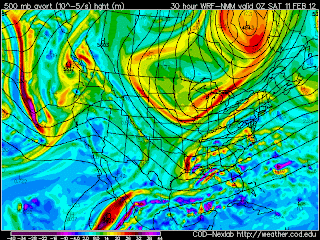 At this point, it seems very likely that the storm from the Gulf will get swept up by the cold front and actually stall the front. A new Low should will redevelop and quickly intesify. There is not much agreement on where this new storm will form as of right now. And we all know that location makes all the difference in the world with winter storms!
The thinking right now is that it should be cold enough for all snow everywhere, except for a some rain to start on the Cape. The new storm should begin to affect us by Saturday morning and last through the day on Saturday. Totals are up in the air right now but early estimates put 4-8 inches on the South Shore and the Cape (early rain shouldn't matter much) , 2-4 around Boston and inside of 495, 1-3 to the points north and west. Winds will be very gusty as the low rapidly strengthens. It will be a quick mover and should be in the Gulf of Maine by Saturday night.
Of course, this storm hasn't even formed yet and all caution is advised for a large bust potential! There was no real indication of this type of event until this morning and as I mentioned before, it all depends on where the secondary storm develops and how much heavy moisture it can throw back our way. Tonight's model runs will be very interesting to watch for.
The Deets:
A relatively strong cold front will be heading our way on Friday night, shown in the image below. This cold front will mark the beginning of some very cold air that will be settling over New England on Sunday courtesy of an Arctic High sitting over Eastern Canada. Now by itself, this front wouldn't be a problem. In fact, up until this morning, most models had the front touching off a few snow showers but that's it.

Starting this morning, the models started to indicate that the cold front was going to pick up a piece of weak energy moving northeast from the Gulf of Mexico, shown on the upper level map below.
 At this point, it seems very likely that the storm from the Gulf will get swept up by the cold front and actually stall the front. A new Low should will redevelop and quickly intesify. There is not much agreement on where this new storm will form as of right now. And we all know that location makes all the difference in the world with winter storms!
The thinking right now is that it should be cold enough for all snow everywhere, except for a some rain to start on the Cape. The new storm should begin to affect us by Saturday morning and last through the day on Saturday. Totals are up in the air right now but early estimates put 4-8 inches on the South Shore and the Cape (early rain shouldn't matter much) , 2-4 around Boston and inside of 495, 1-3 to the points north and west. Winds will be very gusty as the low rapidly strengthens. It will be a quick mover and should be in the Gulf of Maine by Saturday night.
Of course, this storm hasn't even formed yet and all caution is advised for a large bust potential! There was no real indication of this type of event until this morning and as I mentioned before, it all depends on where the secondary storm develops and how much heavy moisture it can throw back our way. Tonight's model runs will be very interesting to watch for.
Tuesday, February 7, 2012
The Week Ahead
We are in for another fairly tame week in the weather department. Two days ago was the 34th anniversary of the Blizzard of 78 highlighting the fact that early February is typically our most active period of the winter but this winter has been anything but typical.
Today will be mostly sunny as high pressure builds to our east. Overnight, a weak upper level storm approaches us from the south but most indications are that it stays too far south to bring any snowfall. Thursday and Friday will feature plenty of sunshine and very comfortable temperatures in the low 40.s. By Saturday, an strong cold front will approach from the west, marking the leading edge of some truely Arctic air. Some models indicate a small disturbance
forming near Long Island as the front passes by but right now it looks like it would form too late to bring any snowfall.
Either way, expect temperatures to begin falling by Sunday night, into the single digits in most places to even below 0 in elevated areas. Sunday night into Monday could see some record
breaking low temperatures and dew points. Of course, all of this cold and dry air will keep us storm free for the next 5-7 days.
Subscribe to:
Posts (Atom)