Damn. It was hot today.
- From 3-5 this afternoon, the city of Boston sat at 103 degrees, the second highest temperature ever recorded in the city with the highest value being only 1 degree higher (104 July 4th 1911)
- We tied the record high for the day from 1926. So don't go all global warming on me. Yes, this is unusually hot for Boston, but it does happen from time to time and it is summer time. The rest of the country has been in this extreme heat for most of the summer. We just got our first taste today.
- Tonight will not be a comfortable night for sleeping. Dew points are getting lower, but the air temperature is just not dropping. In fact, we may set another record for the highest minimum temperature recorded.
- Despite drier air working its way into our area on Saturday, we will still manage to get very hot, with a high temperature of anywhere from 96-99 degrees. Unlikely we reach 100 again. It won't feel as bad as today but hot is hot and we have one more day of it.
- Sunday will feel like heaven compared to the last few days. 80 degrees and low humidity. Just tough it out until then and make friends with someone who has a pool
Friday, July 22, 2011
Monday, July 18, 2011
Heat Wave Finally Gets Us
This week will be a hot one. Thursday and Friday will be the worst of it. We might even hit 100 on Friday! Take a look at the predicted high temps for Friday.

The whole east coast will be baking, with dew points running very high too. It will be a very uncomfortable day. The record for for July 21st is 102 and we will be close to that reading.

The whole east coast will be baking, with dew points running very high too. It will be a very uncomfortable day. The record for for July 21st is 102 and we will be close to that reading.
Saturday, July 16, 2011
Beautiful Weekend, Severe Storms on Monday
It can't get much better than the stretch of weather we have had for the past week. Yesterday was only 79 degrees in Boston with low humidity and plenty of sunshine. That feels more like September than July!
Outside of some late afternoon thunderstorms on Wednesday, we here in New England have been living the good life while the rest of the country bakes. Even precipitation wise, we have had it good. We are a good 2 inches under where we normally are for the month of July. Just perfect conditions.
Just look at the forecasted high temperatures for tomorrow. Middle America is really feeling the heat. Those poor people have had triple digit temps for a good week now and there is no end in sight.
 Why has it been this way? A very strong and persistent ridge, a dip in the jet stream, has been holding court over the west coast, keeping them cool and cloudy while at the same time opening up the flood gates for the rest of the country. Look at tomorrows jet stream map and you might be able to see what I mean.
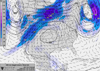 See it? A huge ridge of high pressure is sitting right over Nebraska and it has pretty much been there for the whole month of July. Meanwhile, we here in the northeast have avoided most of the core heat. Starting tomorrow though, we will see our temps and dew points steadily rising, making both Sunday and Monday much more uncomfortable than the past few days have been.
Which brings me to my last point. Monday afternoon looks to have some strong thunderstorm potential. In fact, the set up is similar to the one we had back on June 1st, the same day of the tornado "outbreak" in western MA. I am not saying that we will have another tornado situation. That seems pretty unlikely given how rare it is in the first place and how far into the summer season we are now. But the threat of severe thunderstorms will be real.
I will try to have more on this later but I make no promises since I will be at Kevin Mann's wedding tomorrow!
Subscribe to:
Posts (Atom)