Outside of some late afternoon thunderstorms on Wednesday, we here in New England have been living the good life while the rest of the country bakes. Even precipitation wise, we have had it good. We are a good 2 inches under where we normally are for the month of July. Just perfect conditions.
Just look at the forecasted high temperatures for tomorrow. Middle America is really feeling the heat. Those poor people have had triple digit temps for a good week now and there is no end in sight.
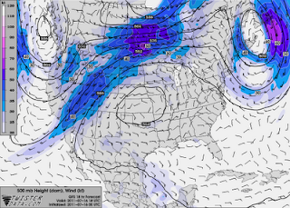
 Why has it been this way? A very strong and persistent ridge, a dip in the jet stream, has been holding court over the west coast, keeping them cool and cloudy while at the same time opening up the flood gates for the rest of the country. Look at tomorrows jet stream map and you might be able to see what I mean.
 See it? A huge ridge of high pressure is sitting right over Nebraska and it has pretty much been there for the whole month of July. Meanwhile, we here in the northeast have avoided most of the core heat. Starting tomorrow though, we will see our temps and dew points steadily rising, making both Sunday and Monday much more uncomfortable than the past few days have been.
Which brings me to my last point. Monday afternoon looks to have some strong thunderstorm potential. In fact, the set up is similar to the one we had back on June 1st, the same day of the tornado "outbreak" in western MA. I am not saying that we will have another tornado situation. That seems pretty unlikely given how rare it is in the first place and how far into the summer season we are now. But the threat of severe thunderstorms will be real.
I will try to have more on this later but I make no promises since I will be at Kevin Mann's wedding tomorrow!
No comments:
Post a Comment