Monday, August 29, 2011

Goodbye Irene

She has left us, officially entering Canada sometime late last night. But not before causing leaving her mark on pretty much the entire east coast of the country. Let's take a look at the final numbers.

Highest Rainfall Totals
Bunyan, N.C., 14.00 inches
Plum Point, Md., 12.96 inches
Ft. Eustis, Va., 12.52 inches
Ocean City, Md., 12.09 inches
Perry Hall, Md., 12.00 inches
Washington, N.C., 11.31 inches
Camp Springs, Md., 11.21 inches
New Bern, N.C., 11.13 inches
Suffolk, Va., 10.71 inches
Grifton, N.C., 10.53 inches

Highest Wind Gusts
Cedar Island, N.C., 115 mph
Fort Macon, N.C., 92 mph
Hatteras, N.C., 88 mph
Conimicut, R.I., 83 mph
Barrington, R.I., 82 mph
Buxton, N.C., 79 mph
Cape Lookout, N.C., 78 mph
Oregon Inlet, N.C., 78 mph
Cobb Island, Md., 73 mph
Chesapeake Beach, Md., 72 mph

Top Rainfall and Wind Gusts in Massachusetts
Conway, 9.92 inchesEast Milton, 81 mph
Ashfield, 9.10 inchesFairhaven, 72 mph
Savoy, 9.02 inchesNorwood, 66 mph

Top Rainfall and Wind Gusts in Rhode Island
Warren, 5.37 inchesConimicut, 83 mph
West Glocester, 4.02 inchesBarrington, 82 mph
Burrillville , 3.86 inchesWarwick, 64 mph

Top Rainfall and Wind Gusts in Connecticut
New Hartford,10.15 inchesGroton, 67 mph
Bulls Bridge, 10.02inchesThompson, 66 mph
Torrington, 9.07 inchesBridgeport, 63 mph

The rainfall numbers in Vermont were even more dramatic in a shorter time frame, with most locations picking up anywhere between 3 inches of rain to as much as 9 inches of rain in only a matter of a few hours!! That is why we saw those amazing images of flash flooding up there.

Facts are facts and Irene was not as strong as originally feared. The forecast track that began to take shape a good 48 hours before any landfall was actually the storm track that verified. She drove a little further inland over North Carolina and Virgina than was predicted. This inland position sapped her of a lot of energy and she likely lost all hurricane status by sometime Saturday afternoon. I assume that the National Weather Service will go back and look at the data, possibly reclassifying Irene as a tropical storm just after she made landfall.

As is he case with extra tropical systems, most of her rainfall became situated on the western side of the storm. Her eastern side became almost devoid of moisture as she began to quickly weaken.

Despite her lack of hurricane force winds, you see the kind of damage that was caused in our state alone. Thousands of trees down, tens of thousands without power. Most of Massachusetts suffered some kind of wind related damage but the real story with Irene became her rainfall. She dumped tons of rain all the way up the coast, as you can see from the image posted above.

So was Irene a dud like my brother told me yesterday? Yes and No. Several days out, it was clear that Irene was going to have a big impact on the east coast and that ended up being true. Forecasting the intensity and track of hurricanes is quite hard but forecasters did a great job with this storm. We all saw first hand what even a moderate tropical storm can do damage wise. I keep hearing people say this was no worse than a nor easter in the winter but I would have to whole hardily disagree with that. These types of storms are much stronger and much bigger and also carry much more moisture with them. Be thankful that we avoided a direct hit, be thankful that the weathermen were on top of this from the beginning and nailed the forecast (people always forget when weathermen get things right) but also don't get the facts twisted. Tropical systems are dangerous, even when they only take a swipe at us.

So, where do we go from here? Well I imagine that many of you still don't have power and I hope that gets fixed soon. Just about all of us saw some trees fallen and thousands of branches and leaves everywhere. I saw firsthand the fury of the ocean when I went down to castle island yesterday afternoon. The waves were amazing, and I was not even on the open ocean.

Irene will go down as a nuisance for most people. But consider yourselves forewarned. The tropics are being VERY active right now and trends tend to emerge with the tracks of these storms. All of us should be prepared over the next few weeks for the possibility of another tropical system taking aim at us.

Friday, August 26, 2011

Irene will be just like Gloria(1985)

Some of you might remember Gloria. Some, like myself, might not. The only thing I remember from Hurricane Gloria is from what my mother told me (In my defense, I was only 2). My parents current house in West Roxbury lost power when a power line came down in the backyard and electrified the metal chain link fence. This story, along with my patched together memories of Hurricane Bob (1991) fueled my love of weather. In this, I have no doubt.

But regardless of my passion's origins, I bring up Gloria with good reason. Irene is doing her best to copy Gloria, only 25 years later.

Gloria was actually a tropical storm by the time it affected Boston, but this fact is always omitted whenever I have heard stories about her. It is with this fact that I bring to attention Irene's current weakening state.

It is likely that Irene makes landfall somewhere near New London, CT. Matt Noyes of NECN has been calling for this in excess of 60 hours now, despite the National Hurricane Center's projected Irene path to cross over NYC.

Wether or not Irene is a hurricane or a tropical storm at her time of impact is a non factor. She will be so big, and so spread out that she will have essentially taken her strongest winds(at the core) and averaged them out in a radius of 200 miles. Her overall category might be lowered, but our impacts remain the same. Irene will cause wind damage, storm surge and flash flooding, regardless of her classification.

I do caution people to take her seriously. Many friends and family members have asked me what to expect. I don't envision any doomsday senario that some media outlets might be portraying. But I also don't expect Irene to miss us completely like that which has happened in the last 20 years of the Atlantic Hurricane season. Yes, the last hurricane to actually hit us was Bob in 1991.

The point I am trying to make is this. Irene might not be a fiercely sounding storm by the time she hits come Sunday morning. But her force will be felt by us all. Tropical systems pack a strong punch. Boston will be subject to heavy (40-50mph) sustained winds. Yes, SUSTAINED. That means that at one particular time on Sunday, the wind will be blowing at a consistent speed of 40-50mph. Not gusting but consistent. That will cause some damage. Don't be surprised if you lose power.

Take caution! Listen to local weather forecasts for updates. Irene is coming on Sunday morning. She won't knock us out but she will deliver quite the blow. No pun intended of course.

Thursday, August 25, 2011

Change in Track is Likely

By now, we all know that Irene has shifted her projected track to the west, causing those in the mid atlantic and New York to speak of doomsday while we here in New England talk about how we dodged a bullet.

Both parties are wrong to prematurely speculate on possible outcomes. Yes, the track has shifted west due to the lack of any mid level steering as is noted below in the latest GFS outline of upper level winds as Irene approaches the coast.

The upper level disturbance lies to the north of the great lakes, in Canada. This puts it too far north to interact with Irene in a timely manner, keeping her close to the coast. Also, notice that the strong area of high pressure over the four corner states has set up further west than previously thought, preventing it from pushing Irene further to the east, north east.

The last 24 hours of various model runs have shown this, thus the official change in track. But lets take a closer look at those model runs.

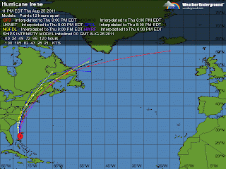
The latest model runs show a split in thinking. Two models take Irene inland over the Chesapeake Bay area and track her center near NYC. This is where the current predicted path lies as well. But two other, just as reliable models, take Irene further east and almost directly over the south shore of Rhode Island and Massachusetts. So why the agreement with the more easterly track?

With weather models, its as much about trend as it is about anything. Recent trends have pulled Irene back to the west for over 24 hours now. And the models predicting this western path have been more accurate in predicting where Irene has gone so far. Therefor, trend and accuracy has officially shifted Irene to the west.

But these other two scenarios are just as statistically likely to happen, they are just not the popular choice. Matt Noyes, who maintains a great personal weather website has been consistantly calling for a landfall somewhere within 60 miles of New London, CT. I completely agree with his prediction.

Two major models calling for a Southern New England landfall are too hard to ignore, especially just over 80 hours away from storm impact. I say, forget recent trend and let's look at historical trend. A hurricane cutting up the Hudson River Valley is not the norm. The earth's rotation along with the higher latitude create those powerful westerly winds known as the westerlies. The further north a system gets, the more to the east, northeast it begins to turn.

Irene will turn to the northeast at some point. Right now, it looks like that happens after she makes landfall near New Jersey. But in 24 hours, that landfall location could have easily shifted back to the east by 100 miles, causing much more damage to southern New England than currently thought.

That said, take preliminary precautions now. Yes, we all make jokes about the people buying all of the milk and bread from grocery stores. But in all honesty, hurricanes are a different beast than our typical Nor' Easters from which we gain so much New Englander pride. They are stronger and much wetter.

At the very least, make preparations to be without power for a few hours. Power lines could easily come down, even with the current Irene track forecast. And the flooding. A large amount of water will be falling from Irene, particularly to the west of her center. 2-6 inches of rain in 12 hours is a lot. Especially for soil that has been very dry for most of the summer. ( Recall last week's torrential rain and resulting urban flooding) Dry soil does not take well to torrential rains.

Be prepared to stay indoors from Sunday afternoon into Sunday night.

Westward Shift in Irene Track


Beginning late last night and continuing today, the models have trended back to the west with Irene's path. This slight shift is due to the presumption that Irene will not get "picked up" by a short wave moving out of Canada which would have pushed her more northeast and towards Boston. She will now likely hug the east coast very closely and bring historic rains and flooding to many of the major cities.


This latest GFS rainfall estimate shows just how much water is going to be dumped along the east coast. Upwards of 8-14 inches in parts of Delaware and New Jersey! New York City should also be concerned with flash flooding and tunnel flooding.

As for Southern New England, while this change in the track has us avoiding a direct hit, we are by no means in the clear. On Saturday, Irene will begin to interact with the cold front that will fire off some severe thunderstorms on our region, which by then will have moved off shore. This interaction will allow her to grow in size, making Irene a very BIG storm in terms of square mileage.

We will actually see some heavy rain in our area starting late Saturday night into Sunday morning. Technically, this rainfall is not part of Irene but you mind as well consider it the beginning of the storms effects.

Since we will be on the eastern side of the storm, expect wind to be the main factor for most of Southern New England. At this point, gusts of 50-95mph seem quite likely to occur on Sunday, with sustained winds probably somewhere from 35-45 mph. Total rainfall from Irene should total around 3-6 inches but I would suspect much of that falls late Saturday night into Sunday morning. Once the eye gets close to eastern Long Island, the vast majority of the rainfall will lie on the western side of the storm.

Storm surge will be a major factor for immediate coastal areas. Tons of water will be pushing northeastward ahead of Irene, likely causing some moderate to major flooding in south facing coastal areas.

So to recap...

- Westward shift in track means less rain for us but raises the possibility of stronger wind gusts and storm surge flooding.
- Storm speed is slowing a bit with lack of mid level driving feature. Landfall expected near NYC sometime Sunday night.
- Heavy rain ahead of the storm begins Saturday night
- Irene will likely be a category 1 or tropical storm by the time she makes landfall, since this new path does not keep her over the water.

This new track is obviously good news for us in Boston but by no means is this guaranteed to occur. You all know that hurricanes are extremely hard to forecast and since this event is still over 72 hours away, there is plenty of time for the track to change. These storms typically turn to the northeast so a path that follows the east coast closely is unusual. Nevertheless, this is how it seems to be playing out right now.

Everyone in the region should be monitoring forecast changes. Usual updates to track changes from the National Hurricane center happen later this evening at 5, 8 and 11.


Wednesday, August 24, 2011

A Trip Down Hurricane Memory Lane

With Irene looking more likely to have a significant impact on Southern New England this weekend, I thought it to be beneficial to take a look back at some similar storms and storm tracks from our recent hurricane history.

Let's jump in the way back machine to 1999. Where were you on September 16th of that year? If you were in Boston, chances are you were hunkering down for Hurricane Floyd.

Floyd was born on September 7th 1999 and took a very similar path to Irene trough the Bahamas. In fact, Floyd's eventual path ended up looking very similar to what forecasts are calling for Irene to do.


Floyd actually became a category 5 hurricane while over the Bahamas and as he approached the eastern seaboard, hurricane watches and warnings were put up at some point from Florida City, FL to Plymouth, MA. President Clinton even went so far as to declare state of emergencies in Florida and Georgia before the storm even made landfall. At the time, Florida was just 7 years removed from the devastating hurricane Andrew. Andrew had also developed in a very similar manor and area as Floyd.

In a mere 24 hours, Floyd went from a category 1 hurricane with maximum sustained winds a 95 knots to a high end category 4 hurricane with maximum sustained winds at 135 knots. In this time period, the central pressure of Floyd dropped 40mb! That is some rapid intensification. Later, in their follow up report of Floyd, the National Hurricane Center attributed this rapid intensification to " the presence of enhanced upper oceanic heat content along its track."

Take a look at the current sea surface temperatures for the Atlantic.

Notice the pool of super heated water that Irene is about to travel over, just east of Florida. This is the same type of situation that allowed Floyd to rapidly intensify. Expect Irene to follow a similar intensification pattern, although she will likely fall short of a category 5.

The next glaring piece of similarities between Floyd and Irene has to do with the projected and eventual path.

As is the case with all tropical systems in the far Atlantic, each storm travels almost due west, riding along the equator and using the prevailing easterly flow to direct its travel. Once these storms enter the Caribbean, they begin to interact with the westerilies or the west trade winds. This ultimately begins to curve the storms into a more north westerly path and then ultimately a north to north easterly path. It is called the storm re curvature period and it has a direct impact on where a hurricane will make landfall if it does at all.

The 500 mb level of the atmosphere is the steering wheel of our atmosphere. It is here where wind direction, troughs and ridges (heights) influence how intense a hurricane will get and where its path will be. The National Hurricane Center had this description of the 500 mb profile that lay in front of Hurricane Floyd,

"As a mid- to upper-tropospheric trough over the eastern United States eroded the subtropical ridge over the extreme western Atlantic, Floyd continued to turn gradually to the right. The center of the hurricane paralleled the central Florida coast, passing about 95 n mi east of Cape Canaveral around 0900 UTC 15 September. By the afternoon of the 15th, Floyd was abeam of the Florida/Georgia border and headed northward toward the Carolinas."


I realize that this explanation is a bit technical. What this statement essentially says is that sinking, drier air to the north and east of Floyd began to dig in behind and to the right of the storm. Combine this with the interaction with the westerlies and you have a hurricane that starts to turn right, just like Floyd did.

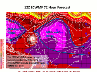
Take a look at this predicted 500 mb steering patterns for Irene

Again, I know this map is a bit technical. Credit for the map and description goes to Phils Tropical Weather Blog. What this (a bit outdated) model shows is quite similar to the steering patterns for Floyd. A strong ridge of high pressure over the atlantic along with strong high pressure over the mid west. In between these two ridges, little short wave troughs ( upper level storms) will continue to move south eastward from Canada. One of these shortwaves will interact with Irene, much like Floyd began to interact with a quickly moving cold front back in 1999. Think of that narrow path between the two high pressure systems as the "cone of uncertainty that you often see with projected hurricane paths.

So, since we can see that Floyd has two very strong similarities to Irene, what ultimately became of Floyd and his impact with New England? This is where I begin to preach caution with anyone getting ahead of themselves with a doomsday prediction. Floyd was ultimately a bust as far as New England was concerned.

He eventually made landfall in extreme eastern North Carolina on September 16th and brought historic and deadly flooding to that whole state. From there, despite hurricane warnings begin posted all of the way to Plymouth, Floyd began to weaken rapidly, as most hurricanes do when they interact with land and colder water.

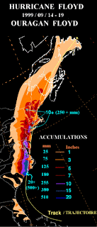
Floyd tracked just to the east of NYC and to the west of Boston, ultimately losing his strong winds but maintaining his heavy tropical rainfall. Looking at the final rainfall totals below, you can see the outrageous amount of rain that fell to the west of the storm. With hurricanes, the heaviest rainfall is always of the western side of the eyewall while the strongest winds lie on the eastern side.

Boston would have been in line to see the strongest winds from Floyd, but he was just barley a tropical storm by the time he got to us on the 17th. We saw our fair share of rain (nothing like North Carolina) but the threat of a catastrophic land falling hurricane for Boston just didn't pan out.

Will this same result happen with Irene? It is impossible to say at this point. Emotions will likely be running high in our region with the threat of a major hurricane. Emergency preparations should certainly be taken and all citizens should be watching for updates on Irene. Just remember that hurricane tracks are EXTREMELY hard to forecast. Probably one of the most difficult things a meteorologist has to do.

Right now, Irene looks like she will stay over water and make landfall as a major hurricane in Southern New England. Back in 1999, Floyd had the exact same expectations and we saw what happened there. Sometimes in these types of scenarios, historical patterns should take precedent over emotionality charged assumptions.

I will have more updates on Irene later tonight.

Monday, August 22, 2011

Irene Deserves Our Attention

The first major hurricane of the 2011 Atlantic season is in the process of forming and she poses a very good chance of making landfall somewhere along the Atlantic east coast. In the past 24 hours, all model guidance has shifted the storm further east, keeping Irene over warm Caribbean water and allowing for further strengthening. Let's look at some details.


Here she is, in all of her glory. Irene is currently a moderate category 1 hurricane with top winds at about 100mph. You can see from this latest water vapor image that Irene is no longer suffering from the shearing effect on her south west side that had been happening earlier today. Combine this with a move to warm ocean waters and you will see rapid strengthening in the next 24 to 48 hours.

The latest computer ensembles (clusters of weather models running different variables) continue to pull Irene further and further to the east. As of 4pm today, it looked like she was going to make a direct hit on South Carolina. Now, it appears as if she will just brush the Outer Banks and make a move up the east coast.

Now, before we begin to get into panic mode, there are many factors that need to play out in order to have this path verify. Follow me, if you will, into weather geek land.

It is a bit fuzzy, I know. This map is an ensemble map of the 500mb level heights, temperature and vorticity. Basically, this map measures spin in the upper atmosphere, the part of the atmosphere that dictates where storms track on the surface. This particular map shows that what we call a upper level short wave will be moving from the Great Lakes to New England sometime on Friday. Depending on how quickly this short wave or spin in the upper atmosphere moves will make a big difference on where Irene goes. If it moves quickly enough, Irene will get sucked up to the North and she will ride up the east coast, picking up tremendous speed and staying over the ocean.

Right now, this looks like the most verifiable situation, with Irene actually cutting inland over New England and bringing torrential rain and some high gusty winds late Saturday night into Sunday.

Of course, this all deserves our attention. Our ocean waters are at the warmest point of the year right now and should Irene stay over the water long enough, we could start to see some hurricane watches be put up later this week. Stay tuned!!