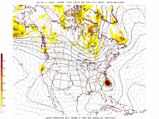
Both parties are wrong to prematurely speculate on possible outcomes. Yes, the track has shifted west due to the lack of any mid level steering as is noted below in the latest GFS outline of upper level winds as Irene approaches the coast.
 The upper level disturbance lies to the north of the great lakes, in Canada. This puts it too far north to interact with Irene in a timely manner, keeping her close to the coast. Also, notice that the strong area of high pressure over the four corner states has set up further west than previously thought, preventing it from pushing Irene further to the east, north east.
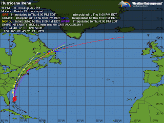
The last 24 hours of various model runs have shown this, thus the official change in track. But lets take a closer look at those model runs.
 The latest model runs show a split in thinking. Two models take Irene inland over the Chesapeake Bay area and track her center near NYC. This is where the current predicted path lies as well. But two other, just as reliable models, take Irene further east and almost directly over the south shore of Rhode Island and Massachusetts. So why the agreement with the more easterly track?
With weather models, its as much about trend as it is about anything. Recent trends have pulled Irene back to the west for over 24 hours now. And the models predicting this western path have been more accurate in predicting where Irene has gone so far. Therefor, trend and accuracy has officially shifted Irene to the west.
But these other two scenarios are just as statistically likely to happen, they are just not the popular choice. Matt Noyes, who maintains a great personal weather website has been consistantly calling for a landfall somewhere within 60 miles of New London, CT. I completely agree with his prediction.
Two major models calling for a Southern New England landfall are too hard to ignore, especially just over 80 hours away from storm impact. I say, forget recent trend and let's look at historical trend. A hurricane cutting up the Hudson River Valley is not the norm. The earth's rotation along with the higher latitude create those powerful westerly winds known as the westerlies. The further north a system gets, the more to the east, northeast it begins to turn.
Irene will turn to the northeast at some point. Right now, it looks like that happens after she makes landfall near New Jersey. But in 24 hours, that landfall location could have easily shifted back to the east by 100 miles, causing much more damage to southern New England than currently thought.
That said, take preliminary precautions now. Yes, we all make jokes about the people buying all of the milk and bread from grocery stores. But in all honesty, hurricanes are a different beast than our typical Nor' Easters from which we gain so much New Englander pride. They are stronger and much wetter.
At the very least, make preparations to be without power for a few hours. Power lines could easily come down, even with the current Irene track forecast. And the flooding. A large amount of water will be falling from Irene, particularly to the west of her center. 2-6 inches of rain in 12 hours is a lot. Especially for soil that has been very dry for most of the summer. ( Recall last week's torrential rain and resulting urban flooding) Dry soil does not take well to torrential rains.
Be prepared to stay indoors from Sunday afternoon into Sunday night.
No comments:
Post a Comment