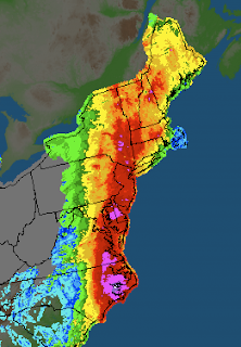
Highest Rainfall Totals
Bunyan, N.C., 14.00 inches

Plum Point, Md., 12.96 inches
Ft. Eustis, Va., 12.52 inches
Ocean City, Md., 12.09 inches
Perry Hall, Md., 12.00 inches
Washington, N.C., 11.31 inches
Camp Springs, Md., 11.21 inches
New Bern, N.C., 11.13 inches
Suffolk, Va., 10.71 inches
Grifton, N.C., 10.53 inches
Highest Wind Gusts
Cedar Island, N.C., 115 mph
Fort Macon, N.C., 92 mph
Hatteras, N.C., 88 mph
Conimicut, R.I., 83 mph
Barrington, R.I., 82 mph
Buxton, N.C., 79 mph
Cape Lookout, N.C., 78 mph
Oregon Inlet, N.C., 78 mph
Cobb Island, Md., 73 mph
Chesapeake Beach, Md., 72 mph
Top Rainfall and Wind Gusts in Massachusetts
| Conway, 9.92 inches | East Milton, 81 mph |
| Ashfield, 9.10 inches | Fairhaven, 72 mph |
| Savoy, 9.02 inches | Norwood, 66 mph |
Top Rainfall and Wind Gusts in Rhode Island
| Warren, 5.37 inches | Conimicut, 83 mph |
| West Glocester, 4.02 inches | Barrington, 82 mph |
| Burrillville , 3.86 inches | Warwick, 64 mph |
Top Rainfall and Wind Gusts in Connecticut
| New Hartford,10.15 inches | Groton, 67 mph |
| Bulls Bridge, 10.02inches | Thompson, 66 mph |
| Torrington, 9.07 inches | Bridgeport, 63 mph |
The rainfall numbers in Vermont were even more dramatic in a shorter time frame, with most locations picking up anywhere between 3 inches of rain to as much as 9 inches of rain in only a matter of a few hours!! That is why we saw those amazing images of flash flooding up there.
Facts are facts and Irene was not as strong as originally feared. The forecast track that began to take shape a good 48 hours before any landfall was actually the storm track that verified. She drove a little further inland over North Carolina and Virgina than was predicted. This inland position sapped her of a lot of energy and she likely lost all hurricane status by sometime Saturday afternoon. I assume that the National Weather Service will go back and look at the data, possibly reclassifying Irene as a tropical storm just after she made landfall.
As is he case with extra tropical systems, most of her rainfall became situated on the western side of the storm. Her eastern side became almost devoid of moisture as she began to quickly weaken.
Despite her lack of hurricane force winds, you see the kind of damage that was caused in our state alone. Thousands of trees down, tens of thousands without power. Most of Massachusetts suffered some kind of wind related damage but the real story with Irene became her rainfall. She dumped tons of rain all the way up the coast, as you can see from the image posted above.
So was Irene a dud like my brother told me yesterday? Yes and No. Several days out, it was clear that Irene was going to have a big impact on the east coast and that ended up being true. Forecasting the intensity and track of hurricanes is quite hard but forecasters did a great job with this storm. We all saw first hand what even a moderate tropical storm can do damage wise. I keep hearing people say this was no worse than a nor easter in the winter but I would have to whole hardily disagree with that. These types of storms are much stronger and much bigger and also carry much more moisture with them. Be thankful that we avoided a direct hit, be thankful that the weathermen were on top of this from the beginning and nailed the forecast (people always forget when weathermen get things right) but also don't get the facts twisted. Tropical systems are dangerous, even when they only take a swipe at us.
So, where do we go from here? Well I imagine that many of you still don't have power and I hope that gets fixed soon. Just about all of us saw some trees fallen and thousands of branches and leaves everywhere. I saw firsthand the fury of the ocean when I went down to castle island yesterday afternoon. The waves were amazing, and I was not even on the open ocean.
Irene will go down as a nuisance for most people. But consider yourselves forewarned. The tropics are being VERY active right now and trends tend to emerge with the tracks of these storms. All of us should be prepared over the next few weeks for the possibility of another tropical system taking aim at us.
No comments:
Post a Comment