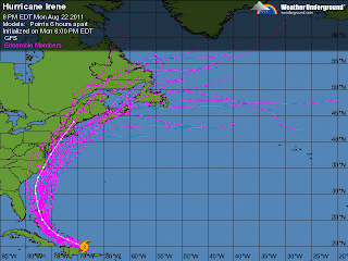
Here she is, in all of her glory. Irene is currently a moderate category 1 hurricane with top winds at about 100mph. You can see from this latest water vapor image that Irene is no longer suffering from the shearing effect on her south west side that had been happening earlier today. Combine this with a move to warm ocean waters and you will see rapid strengthening in the next 24 to 48 hours.
 The latest computer ensembles (clusters of weather models running different variables) continue to pull Irene further and further to the east. As of 4pm today, it looked like she was going to make a direct hit on South Carolina. Now, it appears as if she will just brush the Outer Banks and make a move up the east coast.
Now, before we begin to get into panic mode, there are many factors that need to play out in order to have this path verify. Follow me, if you will, into weather geek land.
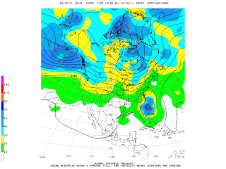
 It is a bit fuzzy, I know. This map is an ensemble map of the 500mb level heights, temperature and vorticity. Basically, this map measures spin in the upper atmosphere, the part of the atmosphere that dictates where storms track on the surface. This particular map shows that what we call a upper level short wave will be moving from the Great Lakes to New England sometime on Friday. Depending on how quickly this short wave or spin in the upper atmosphere moves will make a big difference on where Irene goes. If it moves quickly enough, Irene will get sucked up to the North and she will ride up the east coast, picking up tremendous speed and staying over the ocean.
Right now, this looks like the most verifiable situation, with Irene actually cutting inland over New England and bringing torrential rain and some high gusty winds late Saturday night into Sunday.
Of course, this all deserves our attention. Our ocean waters are at the warmest point of the year right now and should Irene stay over the water long enough, we could start to see some hurricane watches be put up later this week. Stay tuned!!
No comments:
Post a Comment