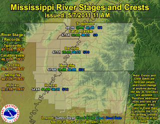
But an additional and potentially much more devastating consequence of an active storm pattern this spring is the tremendous amount of rainfall that has fallen in the lower Mississippi Valley. All of that rain finds its way to the Mississippi River and that river is ready to burst!

Things are getting serious in a hurry. From the image above, you can see that the likely cresting point for the river is sometime next week. But look at those water levels! They are right at record values.
Flooding certainly isn't as "sexy" as tornadoes, but there is no doubt that this type of flooding will be much more devastating than any tornado outbreak can ever be.
No comments:
Post a Comment