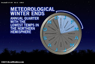
So its March 2nd! Welcome to the start of meteorological spring, with actual spring less than 3 weeks away.
After a record breaking January, the month of February seemed fairly tame. We hit 60 degrees twice. Boston never fell below 13 degrees. We "only" had 18.5 inches of snow. In fact, the majority of our precipitation fell in the form of rain. Despite our break from persistent storms, February did end up being above normal in terms of total precipitation. Even our slow months have been active!
But now it is March. Our sun is getting mighty strong. Any wind from the right direction combined with plenty of sunshine will push high temperatures well into the 50's (as we will see this weekend) As I said in an earlier post, we are on the front lines of the battle between winter and spring. We have seen a roller coaster ride of temperatures that looks to continue through this week and into the next. With every passing front, our temperatures seem to change dramatically. And there will be no better example of that than what we see overnight tonight.
As we speak, our winds have shifted from the mild southwest to the frigid northwest. With clear skies overhead and a strong pool of cold air moving into our region, temps will really bottom out. Suburban areas and higher elevations will be close to 0 while even Boston will get down to about 11 or 12 degrees. The other element will be the wind. Such a change in air mass usually always brings strong winds and tonight is no different. This is really impressive cold air considering how late we are into the season. I almost guarantee that this will be the last time that Boston sees temperatures this cold until next winter. So there is some good news!
Unfortunately, our strong March sun does no good tomorrow and Friday as both days will be pretty cold, especially tomorrow. Highs in the low 20's will be about 20 degrees below normal highs this time of year. Friday is better but again, still cold.
Don't be fooled by the warmer temperatures expected this weekend. Along with those 50 degree readings will be plenty of cloudiness and rain showers, the heaviest of which will likely be on Saturday.
From there, we turn our eyes to another coastal storm on Monday bringing a mixed bag to the region. Either way you cut it, Monday looks yuck. Long term forecast does show a tame, mild week after that though, which means my flight to Ireland should be nice and smooth!
No comments:
Post a Comment